Uthai Thani Province
| Uthai Thani อุทัยธานี | |
|---|---|
| Province | |
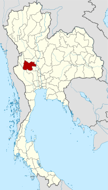 Map of Thailand highlighting Uthai Thani Province | |
| Country |
|
| Capital | Uthai Thani town |
| Government | |
| • Governor | Praphat Malakan (since October 2015) |
| Area | |
| • Total | 6,730.2 km2 (2,598.5 sq mi) |
| Area rank | Ranked 30th |
| Population (2014) | |
| • Total | 330,179 |
| • Rank | Ranked 66th |
| • Density | 49/km2 (130/sq mi) |
| • Density rank | Ranked 72nd |
| Time zone | ICT (UTC+7) |
| ISO 3166 code | TH-61 |
Uthai Thani (Thai: อุทัยธานี) is one of the provinces (changwat) of Thailand. Neighboring provinces are (from north clockwise) Nakhon Sawan, Chai Nat, Suphan Buri, Kanchanaburi, and Tak. It is in Thailand's lower northern region, somewhat off the route between Bangkok and Chiang Mai. It is approximately 200 km from Bangkok.[1]
Geography
The province stretches from the upper plains of the Chao Phraya river valley, to mountains covered with forests in the west. The Sakae Krang River, a tributary of the Chao Phraya River is the main river of Uthai Thani Province.
The Huai Kha Khaeng Wildlife Sanctuary, at the western boundary bordering Tak Province, was declared a World Heritage Site in 1991. It covers 2,574 km2, and is home to most of the forest animals of Southeast Asia, including tigers and elephants.
History
Originally Mon and Lawa settled in the area. The first Thai settlement in the area was Muang U Thai during the Sukhothai period, but it was later abandoned when the river changed course. The Patabeut people, of Karen ethnicity, revived the settlement at its current site during the Ayutthaya period. It served as a fort protecting the boundary of the kingdom.
Uthai Thani is most famous as being the hometown of the father of King Rama I. Rama I also renamed the city from its old name Uthai to Uthai Thani.
In 1892 King Chulalongkorn (Rama V) added the area of Uthai Thani to the Monthon Nakhon Sawan, and in 1898 formed the province.
Symbols
The provincial seal depicts the pavilion at Wat Khao Sakae Krang. It houses the statue of Thongdee, the father of King Rama I and a Buddha footprint. The mountain in the background symbolizes the location of the pavilion on top of Khao Sakae Krang.[2]
The provincial flower is the yellow cotton tree (Cochlospermum regium). The provincial tree is the neem (Azadirachta indica v. siamensis).
The flag of Uthai Thani depicts the provincial seal of Uthai Thani in the middle. The yellow colour at the top of the flag is the colour of the Chakri dynasty, symbolizing gold. The green colour at the bottom is the colour of King Rama I as he was born on a Wednesday, which is associated with green in the Thai calendar. The text below the seal says Uthai Thani Province.
Administrative divisions
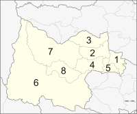
The province is subdivided into eight districts (amphoe). These are further subdivided into 70 subdistricts (tambon) and 642 villages (muban).
Tourism
Sights
Wat Sangkat Rattana Khiri (วัดสังกัสรัตนคีรี): Inside the main hall is "Phra Phuttha Mongkhon Saksit" (Thai: พระพุทธมงคลศักดิ์สิทธิ์) or "Luang Pho Mongkhon" (Thai: หลวงพ่อมงคล), an ancient bronze Buddha image form the Sukhothai period. In addition, in one corner of the temple is a pavilion housing a statue of the father of King Rama I.[3]
Wat Ubosatharam (วัดอุโบสถาราม): Many historical sites and artefacts are found inside. Also of interest are the octagonal multi-tiered roof, the Bot Nam raft, the replica of Lord Buddha’s footprint from the time of King Rama IV, a silver Buddha image and gifts from King Rama V to Luang Pho Chan Wat Bot.
Bot Nam (โบสถ์น้ำ): It was built to receive King Rama V when he visited northern provinces in 1906. Originally a twin raft, it has an elongated carved apex of the gable like normal temple main halls. Today the raft is used by raft residents for religious ceremonies.
Rafts on Sakae Krang River (เรือนแพลำน้ำสะแกกรัง) reflect the lifestyle of Uthai Thani people that has always been linked with water. Water is used here to grow pandanus and for raising fish in floating baskets, particularly gourami. This has become the main occupation of the province and has made it famous.
Wat Chantharam or Wat Tha Sung (วัดจันทารามหรือวัดท่าซุง): It is an old temple from the Ayutthaya period. The item of note in this temple is a pulpit built by Luang Pho Yai. More buildings were later added by the monk Phra Ratchaphrom Yan Nen (Luang Pho Rusi Ling Dam).
Local History and Cultural Museum (ศูนย์วิทยาศาสตร์เทคโนโลยีและสิ่งแวดล้อม): On display are prehistoric human skeletons, clothes, regalia of city lords and a room with wooden models of Thai houses.
Wat Thammakhosok (วัดธรรมโฆษก): This temple was used for holding rites by Uthai Thani government officials where they pledge allegiance to the king. It was also in service as an execution site. The most interesting edifices are the chapel and the main Buddha image hall.
Wat Thap Than (วัดทัพทัน): The items of interest here is the lovely carved door depicting an angel holding an arrow standing on a serpent and another of an angel tending deer holding a pike on a lion.
Thalaad Kwai Thap Than is a lively market for water buffaloes. It is a great opportunity to study these huge mammals in large quantities.
Ban Khok Mo Weaving Village (แหล่งทอผ้าพื้นเมืองบ้านโคกหม้อ) is a small village of Thai-Lao residents whose ancestors migrated here in the Rattanakosin period. Villagers take to weaving when the harvest ends. Their products are made from Sin Tin Chok Silk, Mat Mi silk and traditional-style fabrics with floral patterns.
Bung Khok Chang Ancient City (เมืองโบราณบึงคอกช้าง) was a town surrounded by a moat and an earthen wall. A sacred pond is at the outer corner of each wall. Artefacts unearthed here include tools, utensils and a stone scripture in the Mon language.
Prehistoric colour drawings at Khao Pla Ra (ภาพเขียนสีก่อนประวัติศาสตร์เขาปลาร้า): These coloured cave drawings stretch for around 9 metres. The prehistoric and detailed drawings are of humans and animals in red and black. They are certainly invaluable as part of the artistic heritage of the country.
Tham Hup Pa Tat (ถ้ำหุบป่าตาด): The mountain range surrounding the valley is a limestone range. The way up to this cave is through a margosa forest. The valley has a higher humidity than it surrounds, contributing to the abundant flora.
Tham Khao Khong Chai (ถ้ำเขาฆ้องชัย) is a cave on a limestone mountain range, which is renowned for its natural beauty, with an elevation of about 353 metres. The first cave is large and stone tools and earthenware pieces were discovered here.
Khao Phraya Phai Rua (เขาพระยาพายเรือ): The mountain is shaped like a Chinese junk and is surrounded by a natural moat. It is covered with many species of plants and there are altogether 12 caves leading underground.
Huai Kha Khaeng Wildlife Sanctuary (เขตรักษาพันธุ์สัตว์ป่าห้วยขาแข้ง) consists of almost every kind of forest found in Thailand. The unspoiled nature of the reserve makes it an ideal home to various rare and endangered animals. Due to these attributes, Huai Kha Khaeng Wildlife Reserve was named by UNESCO as a Natural World Heritage Site.
Ban Samo Thong Hot Spring (น้ำพุร้อนบ้านสมอทอง): This is a small spring with clear water, pungent with the aroma of sulphur. The spring has an area of 4,000 square metres and consists of 3 separate springs.
Namtok Cyber (น้ำตกไซเบอร์): The waterfall is situated amidst nature surrounded by the Huai Kha Khaeng forest. The water comes from the western mountain of the nature reserve, resulting in a medium-sized waterfall that drops down several levels before splashing on the boulders below.
Wat Khao Wong (วัดเขาวงพรหมจรรย์) is a temple in a valley. It has a beautiful two-storey Thai-style convocation hall. The monastery is the 13th of 19 branches of Wat Sangkhathan in Nonthaburi. Other branches can be found in places such as Chiang Mai, Um Phang, the United Kingdom and India.
Lan Sak Amphoe: Very old teak trees line this picturesque town's access roads. The town is famous for solid furniture made from this precious wood.
Namtok Pha Rom Yen (น้ำตกผาร่มเย็น): The highlight of this waterfall lies its uniqueness of being a limestone waterfall that falls from a cliff. It can be clearly seen from the road nearby. This beautiful waterfall flows from a small stream four levels up.
Ban I Mat-I Sai Hill Tribe Cultural Centre is in Tambon Kaen Makrut. The centre has a house with a raised lower floor, a thatched roof and bamboo walls.
Local products
Crispy Khao Kung Krop (ข้าวกุ้งกรอบ) is made from rice and shrimp mixed together and then deep-fried. Leading items in the local restaurants are mainly made with fresh-water fish caught from the river. Pomelo is also widely grown on Ko Thepho.
Local woven materials (ผ้าทอพื้นเมือง)
Products made from bamboo and water hyacinth (เครื่องจักสานจากไม้ไผ่และผักตบชวา)
Culture
Festivals
The Tak Bat Thewo Fair (งานตักบาตรเทโว) at Wat Sangkat Rattanakhiri is the most important event and is held around October. Hundreds of monks residing within the Mueang district walk down the steps from the top of Khao Sakaekrang to accept food offerings from Buddhist devotees who gather in the ground of the temple. The fair is based on the traditional belief that the Lord Buddha on one occasion returned to earth from heaven.
References
- ↑ "Uthai Thani". Tourism Authority of Thailand (TAT). Retrieved 20 Apr 2015.
- ↑ "Khao Sakae Krang". Tourism Authority of Thailand (TAT). Retrieved 20 Apr 2015.
- ↑ "Wat Sangkat Rattana Khiri". Tourism Authority of Thailand (TAT). Retrieved 20 Apr 2015.
External links
| Wikimedia Commons has media related to Uthai Thani. |
- Website of the province (Thai only)
 |
Nakhon Sawan Province | | ||
| Tak Province | |
Chainat Province | ||
| ||||
| | ||||
| Kanchanaburi Province | Suphanburi Province |
Coordinates: 15°22′24″N 100°02′19″E / 15.37333°N 100.03861°E