Urrugne
| Urrugne | |
|---|---|
|
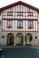
Town Hall | |
 Urrugne | |
|
Location within Nouvelle-Aquitaine region  Urrugne | |
| Coordinates: 43°21′47″N 1°41′56″W / 43.3631°N 1.6989°WCoordinates: 43°21′47″N 1°41′56″W / 43.3631°N 1.6989°W | |
| Country | France |
| Region | Nouvelle-Aquitaine |
| Department | Pyrénées-Atlantiques |
| Arrondissement | Bayonne |
| Canton | Hendaye |
| Intercommunality | Communauté de communes du Sud Pays Basque |
| Government | |
| • Mayor (2008–2014) | Odile de Coral |
| Area1 | 50.57 km2 (19.53 sq mi) |
| Population (2006)2 | 7,668 |
| • Density | 150/km2 (390/sq mi) |
| Time zone | CET (UTC+1) |
| • Summer (DST) | CEST (UTC+2) |
| INSEE/Postal code | 64545 / 64122 |
| Elevation |
0–880 m (0–2,887 ft) (avg. 32 m or 105 ft) |
|
1 French Land Register data, which excludes lakes, ponds, glaciers > 1 km² (0.386 sq mi or 247 acres) and river estuaries. 2 Population without double counting: residents of multiple communes (e.g., students and military personnel) only counted once. | |
Urrugne (Basque Urruña) is a village in the traditional Basque province of Labourd, now a commune in the Pyrénées-Atlantiques department in south-western France.
See also
References
External links
| Wikimedia Commons has media related to Urrugne. |
Municipalities in Labourd (Lapurdi) | ||
|---|---|---|
|  | |
This article is issued from Wikipedia - version of the 3/15/2016. The text is available under the Creative Commons Attribution/Share Alike but additional terms may apply for the media files.