Urbana, Ohio
| Urbana, Ohio | |
|---|---|
| City | |
|
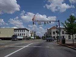
Located at the center of Urbana is a large traffic circle. | |
 Location of Urbana, Ohio | |
 Location of Urbana in Champaign County | |
| Coordinates: 40°6′39″N 83°45′5″W / 40.11083°N 83.75139°WCoordinates: 40°6′39″N 83°45′5″W / 40.11083°N 83.75139°W | |
| Country | United States |
| State | Ohio |
| County | Champaign |
| Government | |
| • Mayor | Bill Bean |
| Area[1] | |
| • Total | 7.77 sq mi (20.12 km2) |
| • Land | 7.75 sq mi (20.07 km2) |
| • Water | 0.02 sq mi (0.05 km2) |
| Elevation[2] | 1,050 ft (320 m) |
| Population (2010)[3] | |
| • Total | 11,793 |
| • Estimate (2012[4]) | 11,639 |
| • Density | 1,521.7/sq mi (587.5/km2) |
| Time zone | Eastern (EST) (UTC-5) |
| • Summer (DST) | EDT (UTC-4) |
| ZIP code | 43078 |
| Area code(s) | 937 |
| FIPS code | 39-79072[5] |
| GNIS feature ID | 1065415[2] |
| Website | http://urbanaohio.com/ |
Urbana is a city in and the county seat of Champaign County, Ohio, United States,[6] 47 miles (76 km) west of Columbus. Urbana was laid out in 1805, and for a time in 1812 was the headquarters of the Northwestern army during the War of 1812. It is the burial place of the explorer and Indian fighter Simon Kenton.
In 1900, 6,808 people lived in Urbana; in 1910, 7,739; and in 1940, 8,335. The population was 11,793 at the 2010 census. It is the home of Urbana University.
History
Champaign County was formed on February 20, 1805 following the American Revolution and the Northwest Indian War. Colonel William Ward, a Virginian who had settled in the Mad River Valley with Simon Kenton in 1799, purchased 160 acres which he considered the logical and most acceptable site for Champaign's county seat. He approached the county commissioners with a proposition to locate the seat of the new county on this tract. Ward suggested that site to divided into 212 lots and 22 out-lots, half of which, selected alternately, were to be given to the county and while Ward would retain the remainder. Ward also offered two lots for a cemetery and a tract for the public square. The county commissioners approved the proposal, and Ward, with Joseph C. Vance, entered into a written agreement on October 11, 1805. Ward and Vance named the new county seat, Urbana.[7]
The origin of the name 'Urbana' is unclear, however, it is thought that Ward and Vance used the Latin word 'urbs', which means city.[8] Antrim provides the following theory: "It is said by some that Mr. Ward named the town from the word Urbanity, but I think it is quite likely he named it from an old Roman custom of dividing their people into different classes – one class, the Plebeians, and this again divided into two classes – Plebs Rustica and Plebs Urbana. The Plebs Rustica lived in the rural districts and were farmers, while the Plebs Urbana lived in villages and were mechanics and artisans."[9] Others feel that Ward and Vance chose to name it from a town in Virginia, possibly Urbanna, but this seems unlikely. Urbanna means 'City of Anne' and was named for the English queen. It is more likely that two Revolutionary War veterans would turn to Latin rather than honor their former foe. A review in 1939 shows that of the 12 cities in the United States named "Urbana", the city in Ohio was the first.[10]
When Ward delegated Vance to survey the site, there were no platted towns between Detroit and Springfield to use as a model. Nevertheless, Vance and Ward planned Urbana systematically. They provided for an ample public square, and laid the streets in an orderly pattern with no deviations for bogs and swamps.[8]
By 1833, Urbana contained a courthouse and jail, one printing office, a church, a market house, nine mercantile stores, and 120 houses.[11]
On June 4, 1897, residents of Urbana formed a lynch mob and fought their way into the town jail to remove Charles Mitchell, a black man who was suspect in the killing of a white. Crowds of men had been forming for more than a day. The mob hanged Mitchell in the courtyard of the courthouse in the middle of the night. Trying to protect him, Sheriff McCain had summoned the state militia, led by Captain Leonard. After the mob fired into the jail, the militia returned at least five shots, killing Harry Bell, one of the white mob, and wounding others. When the lynch mob gained entry after 2:30 am, the sheriff withdrew militia forces to an upper floor in retreat.[12]
On June 21, 2009, a skatepark was added to Urbana's Melvin Miller Park. The skatepark was designed by Kevin Shockey and constructed by Yoder Concrete Construction, LLC. On November 2013, Damien Pendergast, who was a local skateboarder, died from germ cell cancer. Following his death, his high school class raised $700 and support to dedicate the skatepark in Damien's name.[13][14]
Geography
Urbana is located at 40°6′39″N 83°45′5″W / 40.11083°N 83.75139°W (40.110937, -83.751463).[15]
According to the United States Census Bureau, the city has a total area of 7.77 square miles (20.12 km2), of which 7.75 square miles (20.07 km2) is land and 0.02 square miles (0.05 km2) is water.[1]
Demographics
| Historical population | |||
|---|---|---|---|
| Census | Pop. | %± | |
| 1820 | 644 | — | |
| 1830 | 1,102 | 71.1% | |
| 1840 | 1,070 | −2.9% | |
| 1850 | 2,020 | 88.8% | |
| 1860 | 3,429 | 69.8% | |
| 1870 | 4,276 | 24.7% | |
| 1880 | 6,252 | 46.2% | |
| 1890 | 6,510 | 4.1% | |
| 1900 | 6,808 | 4.6% | |
| 1910 | 7,739 | 13.7% | |
| 1920 | 7,621 | −1.5% | |
| 1930 | 7,742 | 1.6% | |
| 1940 | 8,335 | 7.7% | |
| 1950 | 9,335 | 12.0% | |
| 1960 | 10,461 | 12.1% | |
| 1970 | 11,237 | 7.4% | |
| 1980 | 10,774 | −4.1% | |
| 1990 | 11,353 | 5.4% | |
| 2000 | 11,613 | 2.3% | |
| 2010 | 11,793 | 1.5% | |
| Est. 2015 | 11,547 | [16] | −2.1% |
| [5][17][18][19][20] | |||
2010 census
As of the census[3] of 2010, there were 11,793 people, 4,808 households, and 2,932 families residing in the city. The population density was 1,521.7 inhabitants per square mile (587.5/km2). There were 5,401 housing units at an average density of 696.9 per square mile (269.1/km2). The racial makeup of the city was 89.7% White, 5.4% African American, 0.4% Native American, 0.7% Asian, 0.7% from other races, and 3.1% from two or more races. Hispanic or Latino of any race were 2.0% of the population.
There were 4,808 households of which 31.0% had children under the age of 18 living with them, 41.3% were married couples living together, 14.4% had a female householder with no husband present, 5.2% had a male householder with no wife present, and 39.0% were non-families. 33.0% of all households were made up of individuals and 14.4% had someone living alone who was 65 years of age or older. The average household size was 2.34 and the average family size was 2.95.
The median age in the city was 38.2 years. 23.7% of residents were under the age of 18; 11.4% were between the ages of 18 and 24; 23.1% were from 25 to 44; 25.3% were from 45 to 64; and 16.4% were 65 years of age or older. The gender makeup of the city was 47.1% male and 52.9% female.
2000 census
As of the census[5] of 2000, there were 11,613 people, 4,859 households, and 2,998 families residing in the city. The population density was 1,702.3 people per square mile (657.4/km²). There were 5,210 housing units at an average density of 763.7 per square mile (295.0/km²). The racial makeup of the city was 91.03% White, 5.95% African American, 0.34% Native American, 0.30% Asian, 0.03% Pacific Islander, 0.48% from other races, and 1.88% from two or more races. Hispanic or Latino of any race were 1.08% of the population.
There were 4,859 households out of which 29.0% had children under the age of 18 living with them, 46.2% were married couples living together, 11.8% had a female householder with no husband present, and 38.3% were non-families. 33.4% of all households were made up of individuals and 13.1% had someone living alone who was 65 years of age or older. The average household size was 2.29 and the average family size was 2.92.
In the city the population was spread out with 23.7% under the age of 18, 9.8% from 18 to 24, 27.9% from 25 to 44, 22.4% from 45 to 64, and 16.2% who were 65 years of age or older. The median age was 37 years. For every 100 females there were 87.2 males. For every 100 females age 18 and over, there were 83.6 males.
The median income for a household in the city was $33,702, and the median income for a family was $42,857. Males had a median income of $33,092 versus $26,817 for females. The per capita income for the city was $17,831. About 7.2% of families and 10.9% of the population were below the poverty line, including 16.3% of those under age 18 and 7.6% of those age 65 or over.
Economy
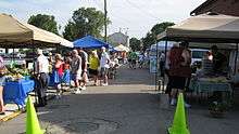
Urbana's economy is supported by several industries, including Rittal, Honeywell Aerospace, Honeywell Inc., Control Industries, Freshwater Farms among others. A variety of services are located in buildings around the Urbana Monument Square Historic District, which is listed on the National Register of Historic Places. Businesses in the square include banks, accounting, fine dining, bars, and personal care. The Champaign County Farmers Market is held weekly in downtown Urbana. In a contest sponsored by the American Farmland Trust, the market was voted as one of America's four favorite farmers' markets.[21] Urbana is also home to the annual Simon Kenton Chili Cook-Off that takes place downtown in the monument square as well.The 8th annual Cook-Off is taking place on September 26, 2015 where prizes will be offered to the winners.[22]
Education
Urbana is primarily served by the Urbana City School District, which includes Urbana High School. Additional lower schools are North Elementary, which accepts students in grades K-2; South Elementary, K-2; East Elementary, grades 3-4; and Local Intermediate, a school for grades 5-6; one of the newer buildings, it is located on the outskirts of town.
Urbana University offers liberal arts tertiary-education opportunities in a small college environment. Serving about 1500 students, it offers 28 undergraduate majors in a variety of disciplines; graduate degrees in Business Administration, Criminal Justice, Education and Nursing; and opportunities for international students desiring to study in the United States.
Notable people
- Clancy Brown – born in Urbana in 1959, producer and actor (The Shawshank Redemption), son of Congressman Bud Brown (below)
- Clarence J. "Bud" Brown Jr., lived in Urbana in 1950s and early 1960s, US Congressman (1965 to 1983) and CEO of Brown Publishing Company
- Moses Bledso Corwin – attorney and member of United States House of Representatives
- Pete Dye – golf course architect voted into the Hall of Fame; grew up in Urbana
- Robert Morton Duncan – lawyer and jurist
- Robert L. Eichelberger – United States Army general who commanded the US Eighth Army in the South West Pacific Area during World War II
- Warren G. Grimes (1898–1975) – "Father of the Aircraft Lighting Industry," entrepreneur and inventor
- Charles T. Hinde – businessman and riverboat captain
- Edmund C. Hinde – miner during the California Gold Rush
- Robert R. Hitt – United States Assistant Secretary of State, born in Urbana in 1834
- Raymond Hubbell – composer of musicals, including the song "Poor Butterfly"
- Michael Kent - Comedian and Magician
- Simon Kenton – frontiersman; buried in Urbana
- Tony Locke – Arena Football League wide receiver
- Joseph Vance – 13th Governor of Ohio; lived in Urbana and is buried there
- Martin R. M. Wallace - Civil War general, born in Urbana
- W. H. L. Wallace - Civil War general, born in Urbana
- Colonel William Ward – founder of Urbana
- John Quincy Adams Ward – sculptor of the George Washington statue at Federal Hall National Memorial on Wall Street in New York City
- Edgar Melville Ward – painter and educator
- Brand Whitlock – born and raised in Urbana; four-time mayor of Toledo, Ohio and appointed as Ambassador to Belgium by President Woodrow Wilson
Transportation

- A mid-air crash between TWA Flight 553 and a Beechcraft Baron over Urbana on March 9, 1967 resulted in 26 fatalities.
- Urbana was a stop along the Pittsburgh, Cincinnati, Chicago and St. Louis Railroad, which connected Pittsburgh to Chicago and St. Louis.
- A B-17 bomber from World War II is being restored by volunteers at Grimes Field, the local airport.
See also
- Curry Normal and Industrial Institute
- Grimes Field
- Urbana Daily Citizen - local newspaper
- Urbana Monument Square Historic District
- Champaign Aviation Museum
References
- 1 2 "US Gazetteer files 2010". United States Census Bureau. Retrieved 2013-01-06.
- 1 2 "US Board on Geographic Names". United States Geological Survey. 2007-10-25. Retrieved 2008-01-31.
- 1 2 "American FactFinder". United States Census Bureau. Retrieved 2013-01-06.
- ↑ "Population Estimates". United States Census Bureau. Retrieved 2013-06-17.
- 1 2 3 "American FactFinder". United States Census Bureau. Retrieved 2008-01-31.
- ↑ "Find a County". National Association of Counties. Retrieved 2011-06-07.
- ↑ Evan P. Middleton (1917). History of Champaign County, Ohio Its People, Industries and Institutions. B.F. Bowen. p. 1089.
- 1 2 Writers' Program (Ohio) (1942). Urbana and Champaign county. Urbana, O., Gaumer publishing company.
- ↑ Antrim, Joshua (1872). The history of Champaign and Logan counties: from their first settlement. Bellefontaine, Ohio : Press Printing Co. p. 5.
- ↑ "Urbana claims honor of first using name". The Evening Review (East Liverpool, Ohio). 10 Feb 1939. p. 22.
- ↑ Kilbourn, John (1833). "The Ohio Gazetteer, or, a Topographical Dictionary". Scott and Wright. p. 458. Retrieved 12 December 2013.
- ↑ "A Lynching At Urbana". New York Times. June 6, 1897.
- ↑ http://www.urbanaohio.com/city-offices/parks-and-recreation-melvin-miller.html
- ↑ http://www.springfieldnewssun.com/news/news/urbana-students-dedicate-skate-park-to-classmate-w/ngFyx/
- ↑ "US Gazetteer files: 2010, 2000, and 1990". United States Census Bureau. 2011-02-12. Retrieved 2011-04-23.
- ↑ "Annual Estimates of the Resident Population for Incorporated Places: April 1, 2010 to July 1, 2015". Retrieved July 2, 2016.
- ↑ "Population: Ohio" (PDF). 1930 US Census. U.S. Census Bureau. Retrieved 28 November 2013.
- ↑ "Number of Inhabitants: Ohio" (PDF). 18th Census of the United States. U.S. Census Bureau. Retrieved 22 November 2013.
- ↑ "Ohio: Population and Housing Unit Counts" (PDF). U.S. Census Bureau. Retrieved 22 November 2013.
- ↑ "Incorporated Places and Minor Civil Divisions Datasets: Subcounty Population Estimates: April 1, 2010 to July 1, 2012". U.S. Census Bureau. Retrieved 25 November 2013.
- ↑ Morrill, Jennifer. "Champaign County, Ohio Farmers Market Voted America’s Favorite Farmers Market", American Farmland Trust, September 28, 2010.
- ↑ http://www.chilicookoffofurbana.com/index.html
External links
| Wikimedia Commons has media related to Urbana, Ohio. |
Municipalities and communities of Champaign County, Ohio, United States | ||
|---|---|---|
| City |  | |
| Villages | ||
| Townships | ||
| CDP | ||
| Unincorporated communities | ||