Urban area (France)
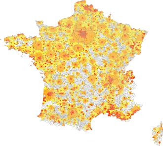
Urban areas of France in 2010, broken down by communes:
Red: urban communes also urban poles of an urban area
Orange: other urban communes in a single urban area
Yellow: urban communes linked to at least two urban areas
White: rural communes
|
An aire urbaine (literal and official translation: "urban area"[1]) is an INSEE (France's national statistics bureau) statistical concept describing a core of urban development and the extent of its commuter activity. When applied to larger agglomerations, this unit becomes similar to a U.S. metropolitan area, and the INSEE sometimes uses the term aire métropolitaine[2] to refer to France's larger aires urbaines.
Composition
The aire urbaine is based on France's nationwide map of interlocking administrative commune municipalities: when a commune has over 2000 inhabitants and contains a centre of dense construction (buildings spaced no more than 200 metres apart), it is combined with other adjoining communes fulfilling the same criteria to become a single unité urbaine ("urban unit"[3]); if an urban unit offers over 10,000 jobs and its economical development is enough to draw more than 40% of the population of a nearby municipalities (and other municipalities drawn to these in the same way) as commuters, it becomes a pôle urbain ("urban cluster"[4]) and the "commuter municipalities" become its couronne ("rim"[5]), but this only on the condition that the urban unit itself is not part of another urban cluster's rim. The aire urbaine is an urban cluster and its rim combined, or a statistical area describing a central urban core and its economic influence on surrounding municipalities.
Lesser aires urbaines
If an urban unit offers 5,000~10,000 jobs (thus becoming an 'average' urban cluster) yet manages to draw commuters numbering more than 40% of the population of nearby municipalities (and other municipalities drawn to these in the same way), the whole qualifies as an 'average' aire urbaine; a 'small' aire urbaine fulfils the same commuter criteria but is centred on an urban unit (or 'small' urban cluster) offering 1,500~5,000 jobs.[6]
List of France's aires urbaines (metropolitan areas)
The following is a list of the twenty largest aires urbaines (metropolitan areas) in France, based on their population at the 2011 census. Population at the 2006 census is indicated for comparison.
Between 2006 and 2011, Toulouse, Rennes, Montpellier, Nantes, Bordeaux and Lyon had the fastest-growing metropolitan areas in France..
| Rank (2011) |
Rank (2006) |
Aire urbaine (metropolitan area) |
Population (2011) |
Population (2006) |
Yearly change (2006-2011) |
Land area (km²) |
|---|---|---|---|---|---|---|
| 1 | 1 | Paris[7] | 12,292,895 | 11,956,493 | +0.56% | 17,174 |
| 2 | 2 | Lyon[8] | 2,188,759 | 2,085,107 | +0.98% | 6,019 |
| 3 | 3 | Marseille - Aix-en-Provence[9] | 1,720,941 | 1,692,459 | +0.33% | 3,174 |
| 4 | 4 | Toulouse[10] | 1,250,251 | 1,169,865 | +1.34% | 5,381 |
| 5 | 5 | Lille (French part)[11] | 1,159,547 | 1,152,507 | +0.12% | 926 |
| 6 | 6 | Bordeaux[12] | 1,140,668 | 1,086,106 | +0.99% | 5,613 |
| 7 | 7 | Nice[13] | 1,003,947 | 995,968 | +0.16% | 2,585 |
| 8 | 8 | Nantes[14] | 884,275 | 841,404 | +1.00% | 3,302 |
| 9 | 9 | Strasbourg (French part)[15] | 764,013 | 749,766 | +0.38% | 2,198 |
| 10 | 12 | Rennes[16] | 679,866 | 637,673 | +1.29% | 3,747 |
| 11 | 10 | Grenoble[17] | 675,122 | 659,459 | +0.47% | 2,621 |
| 12 | 11 | Rouen[18] | 655,013 | 643,499 | +0.36% | 2,367 |
| 13 | 13 | Toulon[19] | 606,987 | 598,514 | +0.28% | 1,196 |
| 14 | 15 | Montpellier[20] | 561,326 | 529,401 | +1.18% | 1,673 |
| 15 | 14 | Douai - Lens[21] | 542,946 | 545,636 | −0.10% | 679 |
| 16 | 17 | Avignon[22] | 515,123 | 501,866 | +0.52% | 2,083 |
| 17 | 16 | Saint-Étienne[23] | 508,548 | 508,284 | +0.01% | 1,689 |
| 18 | 18 | Tours[24] | 480,378 | 469,244 | +0.47% | 3,184 |
| 19 | 19 | Clermont-Ferrand[25] | 467,178 | 454,553 | +0.55% | 2,420 |
| 20 | 20 | Nancy[26] | 434,565 | 432,481 | +0.10% | 2,367 |
See also
- List of communes in France with over 20,000 inhabitants (1999 census)
- Social situation in the French suburbs
- Demographics of France
- List of metropolitan areas in Europe by population
- Larger Urban Zone
- Unité urbaine a related concept
References
- ↑ Definitions and methods: Urban area
- ↑ "Un maillage du territoire français" (in French). Retrieved 2014-10-17.
- ↑ Definitions and methods: Urban unit
- ↑ Definitions and methods: Urban Cluster
- ↑ Definitions and methods: Rim
- ↑ Definitions and methods: Urban area
- ↑ Paris
- ↑ Lyon
- ↑ Marseille-Aix-en-Provence
- ↑ Toulouse
- ↑ Lille
- ↑ Bordeaux
- ↑ Nice
- ↑ Nantes
- ↑ Strasbourg
- ↑ Rennes
- ↑ Grenoble
- ↑ Rouen
- ↑ Toulon
- ↑ Montpellier
- ↑ Douai-Lens
- ↑ Avignon
- ↑ Saint-Étienne
- ↑ Tours
- ↑ Clermont-Ferrand
- ↑ Nancy
External links
- Geopolis: research group,university of Paris-Diderot, France - Population of urban areas of 10,000 or more