Uptown New Orleans
|
Uptown New Orleans Historic District | |
|
The Latter Memorial Library, a former private mansion built in 1907,[1] sits on the corner of St. Charles Avenue and Soniat St. | |
| Location |
New Orleans, Louisiana, United States |
|---|---|
| Architect | Multiple |
| Architectural style | mid-19th-century Revival, late 19th- and 20th-century Revivals, late Victorian, government housing |
| NRHP Reference # | 85001417[2] |
| Added to NRHP | July 3, 1985 |
Uptown is a section of New Orleans, Louisiana, United States, on the east bank of the Mississippi River, encompassing a number of neighborhoods between the French Quarter and the Jefferson Parish line. It remains an area of mixed residential and small commercial properties, with a wealth of 19th-century architecture.[3] It includes part or all of Uptown New Orleans Historic District, which is listed on the National Register of Historic Places.
Boundaries and definitions
Historically, uptown was a direction, meaning movement in the direction against the flow of the Mississippi. After the Louisiana Purchase, many settlers from other parts of the United States developed their homes and businesses in the area upriver from the older Creole city. During the 19th century Canal Street was known as the dividing line between uptown and downtown New Orleans, the boundary between the predominantly Francophone area downriver and the predominantly Anglophone area upriver.
The very broadest definition of Uptown, historically, included everything upriver from Canal Street, which would encompass about one-third of the city. In the narrowest usage, as a New Orleans City Planning neighborhood, Uptown refers to an area of only some dozen blocks centering on the intersection of Jefferson and St. Charles Avenues. Neither of these is what most New Orleanians of recent generations usually mean by uptown. While some may quibble about the exact boundaries, Uptown broadly refers to the areas of the city closer to the River (river side of South Claiborne Avenue) and upriver from the Pontchartrain Expressway and the modern CBD/Warehouse District neighborhood.
The boundaries of the federal Uptown New Orleans Historic District, listed on the National Register of Historic Places, are the River to S. Claiborne Avenue and Jackson Avenue to Broadway. Adjacent areas, which are often colloquially referred to as parts of Uptown are other federal historic districts: Carrollton, the Garden District, the Irish Channel, Central City, and the Lower Garden District.
History
Uptown was developed during the 19th century, mostly from land that had been plantations in the Colonial era. Several sections were originally developed as separate towns, like Lafayette, Jefferson City, Greenville, and Carrollton. For a time in the early 19th century most of Uptown was part of Jefferson Parish until the City of New Orleans annexed them. In 1874, New Orleans added the towns of Lafayette (not to be confused with the present city of the same name in Lafayette Parish), and Carrollton. This newly absorbed area became known as Uptown New Orleans[4][5]
People from other parts of the United States settled uptown in the 19th century, joined by immigrants, notably from Italy, Ireland, and Germany. Uptown has always had a sizable African American population. Census data shows that ethnically and racially mixed blocks were common in the 19th and early 20th centuries, which continues to be the case with much of Uptown.
City of Lafayette
Several small settlements grew up at steamboat landings a few miles upstream of New Orleans. The original Lafayette began as one of these. The sugar plantation once owned by François Livaudais, situated in Jefferson Parish along the Mississippi River between the present Philip, Pleasant, and LaSalle streets, was sold to developers in 1832. It was subdivided and incorporated in April 1833 as the City of Lafayette and included the land which would later become known as the Garden District. The center of town was around Jackson Avenue.
Lafayette was also the site of the original Jefferson Parish court house. The New Orleans and Carrollton Railroad, also incorporated in 1833, constructed a spur from the main line along Nyades Street (now St. Charles Avenue) down Jackson Avenue.[6] Lafayette annexed Faubourg Delassize in 1844, bringing that city's boundary with New Orleans to Toledano Street.[7] In 1852, New Orleans annexed Lafayette, moving the New Orleans city limit upriver to Toledano Street. The seat of Jefferson Parish moved to the City of Carrollton. However, the boundary between Jefferson Parish and Orleans Parish remained at Felicity Street until 1870, when it was moved to Lowerline Street.[8]
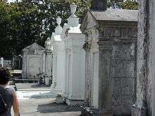
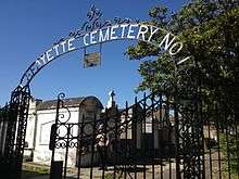
Cornelius Hurst, developer of Faubourg Hurstville, sold a square block to the City of Lafayette for a cemetery in 1833. Now known as Lafayette Cemetery No. 1, the land is bounded by Washington Avenue, 6th Street, Coliseum Street and Prytania Street. In 1972, this cemetery was added to the National Register of Historical Places, but in 1996 it was listed in the 1996 World Monuments Watch by the World Monuments Fund. The Fund helped in the creation of a preservation plan with assistance from American Express.[9] In 2010, the Louisiana Landmarks Society rated Lafayette Cemetery No. 1 as one of the nine most endangered New Orleans landmarks. It said that two large oak trees threatened to destroy 30 tombs. The society also cited inadequate grounds keeping, improper maintenance, and damage by movie film crews as contributing to this decline.[10]
Greenville
Greenville was a city formerly in Jefferson Parish bounded by the present-day Audubon Park and Lowerline Street, and extended from the river to St. Charles Avenue.[11] The city was annexed by New Orleans and became part of Orleans Parish. Although the name of Greenville is sometimes used in referring to a neighborhood in Uptown New Orleans, it should not be confused with the community of the same name in Catahoula Parish, Louisiana.[12]
Jefferson City
By 1850, seven other faubourgs had been created: Plaisance, Delachaise, St. Joseph, East and West Bouligny, Avart, and Rickerville. These combined to form Jefferson City, which extended between Toledano and Joseph Streets.[13] Note that this is not the same location as the present day Jefferson, Louisiana. In 1870, New Orleans annexed Jefferson City, Hurstville, Bloomingdale, Burtheville, and Greenville. It also annexed the undeveloped area between Greenville and Burtheville that would later become Audubon Park.
Uptown Faubourgs and other neighborhoods
Hurstville
Faubourg Hurstville was the first faubourg of what is now Uptown New Orleans, created in 1833 by Cornelius Hurst, a wealthy businessman.[14] It ran along the Mississippi River from Joseph Street to "the Bloomingdale Line" between Eleonore Street and State Street, continuing inland to Claiborne Avenue.[15] The land had been part of a plantation once owned by Jean-Baptiste François LeBreton.
Cornelius Hurst, Pierre Joseph Tricou, and Julie Robert Avart had bought the plantation in 1831, dividing it into three equal parts. Hurst commissioned a plantation house to be built on his land in 1832. The site of this house later became the corner of Tchoupitoulas and Joseph Streets. The house was moved in 1922 to a site at 3 Garden Lane.[16] Tricou sold his part to Hurst in 1832. Hurst's property was surveyed for development into Faubourg Hurstville. Avart's portion became Faubourg Bloomingdale in 1841.[17]
Hurst named three streets perpendicular to the Mississippi River Eleonore, Arabella, and Joseph for his wife, daughter, and son, respectively. He named the fourth street Nashville, as part of his plan to get the New Orleans & Nashville Railroad to construct a spur into his faubourg. However, both Hurst and the railroad went bankrupt during the Panic of 1837, and the proposed track was not built.[18]
Although Hurst himself is largely forgotten, his name lives on as Hurst Street, which crosses the four streets named above. The name Hurstville is still used to identify the former faubourg; and as of 2010, still appears in local news items and real estate listings. The neighborhood streets are almost entirely residential.[19]
Burtheville
This faubourg was once farmland owned by Dominique François Burthe, who bought the property from Bernard de Marigny in 1831. Burthe subdivided the property in 1851 to create Burtheville. It was bounded by the river and Claiborne Avenue, between Webster and State streets.[13] An 1867–1868 directory for New Orleans commented that Burtheville was very sparsely populated.[15]
The United States Marine Hospital was built at the corner of Henry Clay and Tchoupitoulas Streets in 1858, which was expanded in the 20th century to become the U.S. Public Health Service Hospital. In 1983, after the state of Louisiana acquired the property, this facility became the New Orleans Adolescent Hospital.[20]
Rickerville
Rickerville adjoined Hurstville along Joseph Street and extended along the river to Peters (now Jefferson), then inland to Pitt Street.[15] The faubourg was created March 23, 1849, and named for Samuel Ricker, one of the land owners.[13]
Uptown (neighborhood)
According to the Greater New Orleans Community Data Center, Uptown also refers to a specific neighborhood that is bounded by Napoleon Avenue, Magazine Street, Jefferson Avenue and La Salle Street. The neighborhood was once known as Faubourg Bouligny, until it became part of Jefferson City. The area was annexed by New Orleans in 1870.[21]
Cityscape
Uptown was built along the higher ground along an old natural river levee on a wide, gradual bend of the Mississippi. Streets were laid out either roughly following the River's curve or perpendicular to it, resulting in what has been called a "wheel with spokes" street pattern (with the hub inland from Uptown, in the Broadmoor and Mid City areas).
Major roadways echoing the river's crescent include Tchoupitoulas Street closest to the river. Formerly heavily devoted to river shipping commerce, as shipping became more containerized in the later 20th century more of Tchoupitoulas was devoted to residential and other commercial uses. The next major street back is Magazine. While Magazine Street has only one lane of traffic in both directions, it is a major commercial district, known for its many locally owned shops, restaurants, and art galleries. Prytania Street is the next major street inland, although it extends only up to Jefferson Avenue as a major thoroughfare.
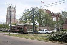
Next is well-known St. Charles Avenue, home to the St. Charles Avenue streetcar line. St. Charles was the city's "millionaires row" in the 19th century, and a good number of the architecturally significant old mansions remain. But much of the avenue holds newer apartment buildings and commercial establishments, and some mansions have been converted to rental units. Farther back, the streets Simon Bolivar, LaSalle, and Freret form another parallel with the river. Farthest back is wide Claiborne Avenue, which until the early 20th century had a canal running down its neutral ground and was the back boundary of development until the drainage pumps designed by A. Baldwin Wood were installed (see: Drainage in New Orleans).
Major "spokes" perpendicular to the river include Melpomene/Martin Luther King Jr. Boulevard; Jackson, Washington, Louisiana, Napoleon, Jefferson, and Nashville Avenues; and Broadway, Carrollton Avenue, and Leonidas Street. Many of these were formerly the main streets of, or boundary lines between, the various early 19th-century towns which were absorbed into the city.
Near the upper end of Uptown, on and around the land used for the 1884 World's Fair, the World Cotton Centennial, are Uptown landmarks Audubon Park, Tulane University, and Loyola University.
Neighborhoods and sections in Uptown
Important neighborhoods and sections of Uptown include, going roughly upriver from Canal Street:
- Central City
- Garden District
- Irish Channel
- Faubourg Bouligny
- Audubon/University District
- Carrollton
- Central Business District
Some definitions of Uptown also include areas back from Claiborne such as the Broadmoor and Fontainebleau neighborhoods. Central Business District, historically also known as the "Old American Quarter," was the earliest area called "Uptown New Orleans," though many no longer include it in their definition of Uptown.
Government and infrastructure
Uptown New Orleans is under the jurisdiction of the city and parish of New Orleans. For details, see New Orleans government.
The United States Postal Service operates an Uptown Station.[22]
Uptowners
Notable Uptowners have included jazz musicians Louis Armstrong, Buddy Bolden, George Brunies, Harry Connick, Jr., Percy Humphrey, the Neville Brothers, Joe "King" Oliver, Leon Roppolo, singers the Boswell Sisters and Mahalia Jackson; inventor A. Baldwin Wood; writers Michael Lewis, Anne Rice, and John Kennedy Toole; ethnobotanist Mark Plotkin; past and present professional football players Archie Manning and his sons Peyton and Eli Manning, Steve Gleason,[23] Drew Brees and Thomas Morstead;[23] New Orleans Saints head coach Sean Payton and owner Tom Benson;[23] and rappers B.G., Birdman (rapper), Soulja Slim and Lil Wayne.
Hurricane Katrina
Like most of the oldest parts of the city developed before 1900 on the city's higher ground, the majority of Uptown had very little flooding from Katrina[24] For this reason, the portion of New Orleans along the riverfront stretching from the Bywater to Carrollton and including about half of Uptown was sometimes called "the Sliver by the River" and "Isle of Denial." High water did affect some portions of Uptown, especially the areas closer to Claiborne Avenue,[24] in some places severely. While 20th-century floods such as from the 1909 hurricane and the May 1995 Louisiana flood affected Uptown, the post-Katrina flooding was worse than anything seen since Sauvé's Crevasse in 1849.
In these areas many old homes were built on piers 0.9 to 1.2 meters (3 to 4 feet) above street level to insure against the occasional disastrous flood.[25] These piers proved to be insufficiently elevated, as the flood water rose an additional 30 to 60 cm (one to two feet). However, the area on the river side of St. Charles Avenue, and some sections farther back, escaped flooding. This was the single largest area of New Orleans to be spared the levee-disaster flood.[24]
For months early in the post-Katrina recovery, Magazine Street became a commercial hub of New Orleans, with many businesses owned and run by locals reopening before chain stores in the metro area.
Education
New Orleans Public Schools operates district public schools, while Recovery School District oversees charter schools.
Open-admission Uptown-area high schools include Walter L. Cohen High School, Eleanor McMain Secondary School, New Orleans Charter Science and Mathematics High School (Sci High), New Orleans College Prep, and Sophie B. Wright Institute of Academic Excellence. As of 2012 Cohen is being phased out, being replaced by College Prep.[26] Sci High is located in the former Allen Elementary School campus.[27] Lusher Charter School, a closed-admissions charter school, is in Uptown,[28] in the former Alcee Fortier High School building.[29] The Lycée Français de la Nouvelle Orléans, a public French immersion charter school, is also in Uptown.[30]
Sojourner Truth Academy, located in Uptown, was established in 2008 and disestablished in 2012.[31]
See also
- History of New Orleans
- List of streets of New Orleans
- National Register of Historic Places listings in Orleans Parish, Louisiana
- Neighborhoods in New Orleans
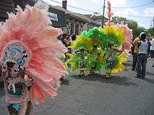
- New Orleans Mardi Gras
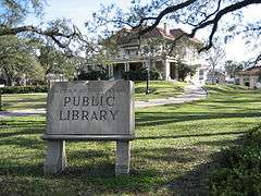
- New Orleans Public Library
- St. Charles Avenue
- St. Charles Streetcar Line
- Wards of New Orleans
References
- ↑ http://www.fodors.com/world/north-america/usa/louisiana/new-orleans/review-194052.html
- ↑ National Park Service (2007-01-23). "National Register Information System". National Register of Historic Places. National Park Service.
- ↑ neworleansonline neighborhoodguide - Garden District, Uptown, and Carrollton
- ↑ prcno.org preservation resource center - neighborhood brochures
- ↑ Dying with history, in Uptown
- ↑ Swanson, Betsy. Historic Jefferson Parish: from shore to shore, p. 101. Retrieved June 7, 2010.
- ↑ Kendall, John. "History of New Orleans" Chapter XLVI "The Annexed Towns." 1922. Retrieved June 7, 2010. .
- ↑ "Swanson"
- ↑ World Monuments Fund - Lafayette Cemetery No. 1
- ↑ Eggler, Bruce. "New Orleans' nine most endangered sites bear legacies of music, worship and justice." Times-Picayune. May 27, 2010. Retrieved June 8, 2010.
- ↑ "Gardner's 1867-68 City Directories for Greenville, Burtheville, Bloomingdale, Hurstville and Rickerville."
- ↑ LA Home Town Locator, Greenville, LA Community Profile
- 1 2 3 Soniat, Meloncy C. The Louisiana Historical Quarterly. "The Faubourgs forming the Upper Section of the City of New Orleans." (1937)
- ↑ New Orleans Architecture Volume VIII: The University Section., p. 11 Available online through Google Books. Accessed April 4, 2010.
- 1 2 3 "Gardner's Burtheville Directory, 1867-68." Transcriber's notes
- ↑ Swanson, Betsy. Historic Jefferson Parish: from shore to shore. 1975. ISBN 0-88-289048-4. pp. 79–80. Available online through Google Books. Accessed May 30, 2010.
- ↑ Campanella, Richard. Time and Place in New Orleans: Past Geographies in the Present Day. 2002. Available online through Google Books. Retrieved May 19, 2010.
- ↑ Chase, John Churchill. Frenchmen, Desire, Good Children and Other Streets of New Orleans. 1949. Available online through Google Books. Accessed May 19, 2010.
- ↑ Bruno, R. Stephanie. NOLA. com. “Handsome houses on Camp Street shine through the rain.” September 3, 2010. Retrieved January 25, 2012.
- ↑ "United States. Marine Hospital (New Orleans, La.) | Tulane University Special Collections"
- ↑ Greater New Orleans Community Data Center Retrieved June 8, 2010.
- ↑ "Post Office Location - UPTOWN STATION." United States Postal Service. Retrieved on March 31, 2010.
- 1 2 3 "Some New Orleans Saints can't resist lure of life in the big city". The Times-Picayune. May 30, 2013.
- 1 2 3 http://www.nola.com/katrina/graphics/depths.swf
- ↑ "Pier Foundation: what is it?" http://www.building-your-green-home.com/pier-foundation.html Accessed 30 July 2010.
- ↑ Morris, Robert. "Open-admission Uptown high schools miss state averages in most subjects." Uptown Messenger. July 6, 2012. Retrieved on August 3, 2012.
- ↑ "The Sci High Story." New Orleans Charter Science and Mathematics High School. Retrieved on August 3, 2012.
- ↑ "About Lusher Charter School." Lusher Charter School. Retrieved on August 3, 2012.
- ↑ Schmid, John. "URBANOMICS REBUILDING AMERICAN'S [sic] INNER CITIES Johnson Controls has a blueprint to revive urban centers across the country while expanding its business. First on its list: Hurricane-ravaged New Orleans. Corporate catalyst for stricken cities." Milwaukee Journal-Sentinel. January 8, 2006. Retrieved on March 18, 2013. "But Lusher took on another challenge in its charter: It agreed to reopen Alcee Fortier High School, one of the state's worst schools."
- ↑ Morris, Robert. "Lycee Francais nearing deal for new school building." Uptown Messenger. November 14, 2011. Retrieved on August 3, 2012.
- ↑ Vanacore, Andrew. "Sojourner Truth Academy to close in May." Times Picayune. Tuesday November 29, 2011. Retrieved on August 3, 2012.
External links
 Media related to Uptown New Orleans at Wikimedia Commons
 Uptown New Orleans travel guide from Wikivoyage