Upper Svratka Highlands
| Upper Svratka Highlands | |
|---|---|
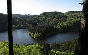 Look over Lake Vir | |
| Highest point | |
| Peak | Devět skal |
| Elevation | 836 m (2,743 ft) |
| Dimensions | |
| Length | 62 km (39 mi) |
| Area | 1,135 km2 (438 sq mi) |
| Geography | |
| Location | Hornosvratecká vrchovina CZ I2C-4.png |
| Country | Czech Republic |
| Region | Moravia |
| Range coordinates | 49°21′N 16°11′E / 49.35°N 16.18°ECoordinates: 49°21′N 16°11′E / 49.35°N 16.18°E |
| Parent range | Bohemian Massif |
| Geology | |
| Orogeny | Variscan |
| Age of rock | Paleozoic, Mesozoic |
| Type of rock | Granite. Quartz slate |

The Upper Svratka Highlands (Czech: Hornosvratecká vrchovina, German: Hohe Schwarza Bergeland , Polish: Wyżyna Górnoswratecka) is a mountain range in Moravia, Czech Republic. The Highlands, together with the Křižanov Highlands threshold, form the Western-Moravian part of Moldanubian Zone - east south part of Bohemian Massif.[1]
Geography
The Upper Svratka Highlands rise to the north of the Tišnov, Moravia between Lomnice u Tišnova, and the Svratka in the north. The Highlands have an area of 1,135 square kilometres (438 sq mi) and an average height of 580 metres (1,900 ft). The highest peak is Devět skal at 836 metres (2,743 ft); other peaks are Křoviska 840 metres (2,760 ft), Žákova hora 810 metres (2,660 ft) Harusův kopec 741 metres (2,431 ft), Babylon 626 metres (2,054 ft), Pohledecká skála 800 metres (2,600 ft), and Přední skála 712 metres (2,336 ft), Kulíšek 692 metres (2,270 ft), Sýkoř 702 metres (2,303 ft), Horní les 774 metres (2,539 ft).
To the southeast is the Boskovická brázda in mid Moravia part of Brno Highlans as well and in the east Svitavy Hills. The Svratka river stream naturally established Bohemian-Moravian border, the other part of Elbe-Danube main European watershed The mountain range is are 63% forested, though mainly by plantations - spruces, maples, beeches, elmeses. The forests are in well condition.
The primary composition of the range is Cretaceous Granite, Migmatite, Orthogneiss, Amphibole, Granodiorite, Gabbro and Quartz slate. Often Gneis. Soil horizon - mainly Cambisol.[2]
The Svratka, Bystřice, Loučka, Nedvědička as well among others, originates here, and the towns include Nové Město na Moravě (eastern part), Bystřice nad Pernštejnem and small towns Doubravník and Nedvědice.
 Look over Lake Vir Moravia
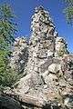 Devět skal rock
.jpg)
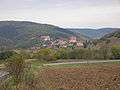 Lomnice u Tišnova - the most southern part of Upper Svratka Highlands
 Doubravník - mausoleum of Lords of Pernstein dynasty
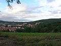 Lomnice near Tišnov
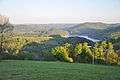
 Vítochov surrounding
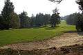 Svratka surrounding
References
Further readings
- Geografický místopisný slovník, Academia, Praha, 1993. ISBN 80-200-0445-9
| Wikimedia Commons has media related to Hornosvratecká vrchovina. |
.jpg)