Upernavik
| Upernavik | |
|---|---|
|
July 2007 aerial view of Upernavik | |
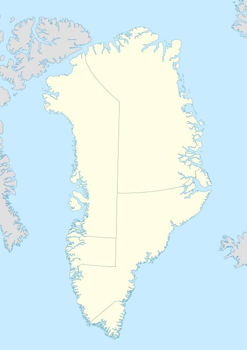 Upernavik Location within Greenland | |
| Coordinates: 72°47′13″N 56°08′50″W / 72.78694°N 56.14722°WCoordinates: 72°47′13″N 56°08′50″W / 72.78694°N 56.14722°W | |
| State |
|
| Constituent country |
|
| Municipality |
|
| Population (2013) | |
| • Total | 1,181[1] |
| Time zone | UTC-3 (UTC-3) |
| Postal code | 3962 |

Upernavik (Kalaallisut: "Springtime Place"[2]) is a small town in the Qaasuitsup municipality in northwestern Greenland, located on a small island of the same name. With 1,181 inhabitants as of 2013,[1] it is the twelfth-largest town in Greenland. Owing to the small size of the settlement, everything is within walking distance. It contains the Upernavik Museum. It is the northern-most town in Greenland with a population of over 1,000.
History

The town was founded as Upernavik in 1772.[3] From the former name of its island, it was sometimes known as Women's Island; its name was also sometimes Anglicized to "Uppernavik".[4] In 1824, the Kingittorsuaq Runestone was found outside the town. It bears runic characters left by Norsemen, probably from the late 13th century. The runic characters list the names of three Norsemen and mention the construction of a rock cairn nearby.
This is the furthest north that any Norse artifacts have been found, other than those small artifacts that could have been carried north by Inuit traders and marks the northern known limit of Viking exploration.
Transport
Air
Upernavik is served by Air Greenland, with scheduled flights from Upernavik Airport to Qaanaaq, Qaarsut, and Ilulissat.[5] Most settlements in the archipelago are served during weekdays with the Bell 212 helicopter.[5]
Sea
In the summer, a small ferry of Royal Arctic Line sails to local villages.
Upernavik Archipelago
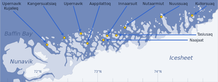
Upernavik is located within Upernavik Archipelago, a vast archipelago of small islands on the coast of northeastern Baffin Bay. The archipelago extends from the northwestern coast of Sigguup Nunaa peninsula in the south at approximately 71°50′N 56°00′W / 71.833°N 56.000°W[6] to the southern end of Melville Bay (Greenlandic: Qimusseriarsuaq) in the north at approximately 74°50′N 57°30′W / 74.833°N 57.500°W.[7]
Population
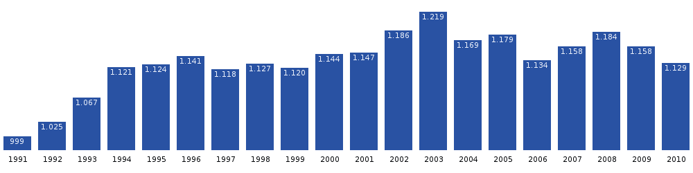
With 1,181 inhabitants as of 2013, Upernavik is the fifth-largest town in the Qaasuitsup municipality.[1] The population has been relatively stable over the last two decades and has increased by more than 28% relative to the 1990 levels,[8] with migrants from the smaller settlements in the archipelago helping keep the population level stable. Cyclist Hanne Malmberg was born in Upernavik. She represented Denmark at the 1992 Summer Olympics.[9]
Climate
| Climate data for Upernavik, Greenland (1961–1990) | |||||||||||||
|---|---|---|---|---|---|---|---|---|---|---|---|---|---|
| Month | Jan | Feb | Mar | Apr | May | Jun | Jul | Aug | Sep | Oct | Nov | Dec | Year |
| Average high °C (°F) | −13.6 (7.5) |
−15.8 (3.6) |
−16.4 (2.5) |
−9.5 (14.9) |
−1.3 (29.7) |
3.9 (39) |
8.0 (46.4) |
7.7 (45.9) |
3.0 (37.4) |
−2.1 (28.2) |
−6.5 (20.3) |
−11.2 (11.8) |
−4.48 (23.93) |
| Average low °C (°F) | −19.8 (−3.6) |
−22.3 (−8.1) |
−23.2 (−9.8) |
−16.6 (2.1) |
−6.5 (20.3) |
−0.9 (30.4) |
2.4 (36.3) |
2.5 (36.5) |
−1.1 (30) |
−5.8 (21.6) |
−10.7 (12.7) |
−16.1 (3) |
−9.84 (14.28) |
| Average precipitation mm (inches) | 12 (0.47) |
13 (0.51) |
8 (0.31) |
14 (0.55) |
10 (0.39) |
14 (0.55) |
29 (1.14) |
26 (1.02) |
38 (1.5) |
33 (1.3) |
34 (1.34) |
20 (0.79) |
251 (9.87) |
| Source: Danish Meteorological Institute[10] | |||||||||||||
Photographs
 Northwestern part of Upernavik in midnight sun
 The cemetery and city behind
 The old church, which is the second-oldest building in the town
 The cemetery; the graves are decorated with artificial flowers.
 Work at the harbour
 Sleddogs chained in residential area
 Duda Lasø anchored in the harbour
References
| Wikimedia Commons has media related to Upernavik. |
- 1 2 3 Greenland in Figures 2013 (PDF). Statistics Greenland. ISBN 978-87-986787-7-9. ISSN 1602-5709. Retrieved 5 September 2013.
- ↑ "greenland-guide.gl" (PDF).
- ↑ Colton, G.W. "Northern America. British, Russian & Danish Possessions In North America." J.H. Colton & Co. (New York), 1855.
- ↑ Walker, J. & al. "British North America." Baldwin & Cradock (London), 1844.
- 1 2 Air Greenland, Departures and Arrivals
- ↑ Nunavik, Saga Map, 1:250.000, Tage Schjøtt, 1992
- ↑ Upernavik Avannarleq, Saga Map, 1:250.000, Tage Schjøtt, 1992
- 1 2 Statistics Greenland, Population in localities
- ↑ "Hanne Malmberg Olympic Results". Olympics at Sports-Reference.com. Sports Reference LLC. Retrieved 27 August 2016.
- ↑ Danish Meteorological Institute (Danish)
Further reading
- Bjerregaard, Peter, and Beth Bjerregaard. Disease Pattern in Upernavik in Relation to Housing Conditions and Social Group. Copenhagen: Kommissionen for videnskabelige Undersøgelser i Grønland, 1985. ISBN 87-17-05231-9
- Haller, Albert Arno. The Spatial Organization of the Marine Hunting Culture in the Upernavik District, Greenland. Ottawa: National Library of Canada, 1981.
- Hjarnø, Jan, Jørgen Balslev Jørgensen, and Morten Vesely. Archaeological and Anthropological Investigations of Late Heathen Graves in Upernavik District. København: C.A. Reitzels Forlag, 1974. ISBN 87-421-0096-8
- Jørgensen, Jørgen Balslev, Jens Dahl, and Sanjai Sangvichien. Anthropometrical Studies on Greenlanders from Two Villages in the Upernavik Area. København: Nyt Nordisk Forlag, 1976. ISBN 87-17-02125-1
- Vibe, Christian. Preliminary Investigations on Shallow Water Animal Communities in the Upernavik- and Thule-Districts (Northwest Greenland). København: C.A. Reitzel, 1939.