Unteraargletscher
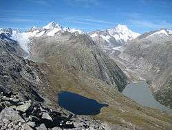
Oberaargletscher (left hand in the background) and Unteraargletscher (on the right). The small blue lake left hand in front is the Triebtenseewli.
| Unteraargletscher | |
|---|---|
|
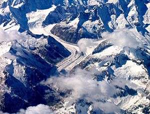
Aerial view from the east | |
| Location | Berne, Switzerland |
| Coordinates | 46°34′0″N 8°13′0″E / 46.56667°N 8.21667°ECoordinates: 46°34′0″N 8°13′0″E / 46.56667°N 8.21667°E |
| Length | 13 km |
The Unteraargletscher (German pronunciation: [ˈʊntərɑːrˌglɛtʃər]), literally "Lower Aare-Glacier", is the larger of the two sources of the Aare river in the Bernese Alps. It emerges from the association of the Finsteraargletscher (near the Finsteraarhorn) and the Lauteraargletscher (near the Lauteraarhorn) and flows for about 6 km (3.7 mi) to the east down to the Grimselsee near the Grimsel Pass. In total the glacier was 12.95 km (8.05 mi) long and 29.48 km2 (11.38 sq mi) in area in 1973. Its lower end is (or was) almost 400 metres lower than that one of the neighbouring Oberaargletscher.
In 18th and 19th centuries, it was one of the first subjects of developing glaciology.
See also
External links
- Swiss glacier monitoring network
- "Viatimages", Université de Lausanne/Bibliothéque nationale Suisse
- Carte du Glacier inférieur de l'Aar, levée en 1842, d'après les directions de m.Agassiz par Jean Wild, Ingénieur (Neuchâtel Public and University Library, cote: IGH Txt 129.6.3)
- Réseau trigonométrique de la carte du glacier inférieur de l'Aar (1847) (Neuchâtel Public and University Library, cote: IGH Txt 129.6.3)
- Carte du glacier inférieur de l'Aar (1844) (Neuchâtel Public and University Library, cote: BPUN Q 820 A)
- Unteraargletscher in the Topographic Atlas of Switzerland 1870–1922
This article is issued from Wikipedia - version of the 8/10/2016. The text is available under the Creative Commons Attribution/Share Alike but additional terms may apply for the media files.