Unsworth
| Unsworth | |
 Castle Lane on the outskirts of Unsworth |
|
 Unsworth |
|
| Population | 9,492 (2011) |
|---|---|
| Metropolitan borough | Bury |
| Metropolitan county | Greater Manchester |
| Region | North West |
| Country | England |
| Sovereign state | United Kingdom |
| Post town | Bury |
| Postcode district | BL9 |
| Dialling code | 0161 |
| Police | Greater Manchester |
| Fire | Greater Manchester |
| Ambulance | North West |
| EU Parliament | North West England |
| UK Parliament | Bury North |
|
|
Coordinates: 53°33′27″N 2°16′48″W / 53.5574°N 2.2801°W
Unsworth is a residential area of the Metropolitan Borough of Bury, in Greater Manchester, England. The population of the Bury ward at the 2011 census was 9,492.[1] It is about 7 miles (11 km) north of the city of Manchester and 4 miles (6.4 km) south of Bury.
Toponomy
Unsworth derives from the Old English Hund a personal name and worth an enclosure. It was recorded in 1291 as Hundeswrth and as Undesworth in 1322.[2]
History
After the Norman conquest in 1066, Unsworth was part of the Pilkington estate before passing into the hands of the Earls of Derby in the 15th century.
In the hearth tax collected in 1666, Unsworth had 40 hearths with no house having six.[3]
Unsworth and Castle Brooks were sources of water for local industries such as bleach and dye works, there was also clay for brickworks. During the Industrial Revolution farming, cotton mills, print-works and bleach-grounds provided employment for its inhabitants. Cotton mills operating in the late 19th century were Worthington and Company whose Victoria Mills contained 220 looms producing ticking, nankeens, linen and drills and the Unsworth Finishing Company.[4]
The first major change in the 20th century was the construction of the Royal Air Force's logistics base at nearby Pilsworth in the Second World War, parts of which remained in use in the early 1980s by shipping firms and other industries.
Unsworth was affected by the construction of the M66 motorway. The road between junctions 3 and 4 passes behind Unsworth Pole and through Back o' th' Moss Farm. Construction of the motorway, along with urbanisation in the mid-1970s reduced the dairy farm's acreage from 300 to 150 acres,resulted in a loss of the dairy production and lower yields of "hay, corn, barley and potatoes"[5]
Governance
Unsworth[6] was a chapelry the eastern portion of the township of Pilkington in the parish of Prestwich-cum-Oldham in the hundred of Salford and county of Lancashire in Northern England.[7][8] When local government was reorganised in 1894, Pilkington ceased to exist as a township and Unsworth gave its name to a new township governed by a parish council made up of Unsworth and Pilsworth with part of Heap.[3]
Historically in Lancashire, the village, with the passage of the Local Government Act 1972, became part of the Metropolitan Borough of Bury on 1 April 1974.
Geography
Unsworth lies on high ground between two brooks running north to Whittle Brook and the River Roch.[3] covering 972 acres of mostly arable land that was boggy until drainage was installed.[7] Parr Brook joins the River Roch at Blackford Bridge.
The village and surrounding area were urbanised in the 1960s. Transformation began in the 1950s with the construction of housing and the road known as Sunny Bank Road connecting the old village to the A56 arterial road between Bury and Manchester.
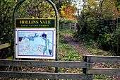
Hollins Vale became Bury’s third local nature reserve in 2003. It is owned by Vidor Waste Management and managed for the benefit of wildlife and the community by the Hollins Conservation Group.[9] Hollins Brook, a tributary of the River Roch meanders through the valley. Most of the area consists of woodland, marshland open grassland which is managed by cattle that roam the area.[10] Hollins Vale was granted Site of Biological Importance status in 1981 due to its diverse range of waterside plants and is one of 50 such sites in the Bury area.[11] The reserve is home to many species of wildlife such as linnet, reed bunting, snipe and grey partridge. The birds and small mammals attract predators such as kestrel, sparrowhawk, buzzard, tawny owl, weasel and stoat. Many species of butterfly are part of the ecosystem as is an increasing rabbit population. Since the construction of the M66, the populations of skylark lapwing and hare have disappeared.
 |
Bolton | Bury | Heywood | |
| Radcliffe | |
Manchester Golf Club | ||
| ||||
| | ||||
| Whitefield | Heaton Park | Middleton |
Demography
Population change
| Population change in Unsworth | |||||||||||||||||||
|---|---|---|---|---|---|---|---|---|---|---|---|---|---|---|---|---|---|---|---|
| Year | 1891 | 1901 | 1911 | 1921 | 1931 | ||||||||||||||
| Population | 2,640 | 2,698 | 2,707 | 2,542 | 2,461 | ||||||||||||||
| Source: A Vision of Britain through Time[12] | |||||||||||||||||||
Religion

Unsworth chapelry included part of the parish of Middleton. St George's Chapel was consecrated in November 1730 on a site provided by the Earl of Derby. The chapel was rebuilt at a cost of £1,500 in 1843.[7] The church is built in brick with a bellcote, and has a graveyard to the north.[13] A screen was installed enclosing the chancel in 1920 and removed in 1988.[14]
In 1846 a chapel was erected by Wesleyan Methodists on Hollins Lane, along with a Sunday school.[15] They have since been demolished and replaced by a Methodist church.[16]
Landmarks

After the First World War, a war memorial was erected at Unsworth Pole, it contains the names of 55 who died in the First World War and three who died in the Second World War.[17]
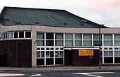
Unsworth Library is part of the Bury Libraries group.[18] [19] Proposals to close the library in 2010 met with opposition.[20][21] Local musician Guy Garvey was amongst the opposers, claiming to have written some of his best lyrics (for his band Elbow) at the library, finding it to be "a source of inspiration”.[22] The proposal was withdrawn in January 2011.[23]
Education

The area was the site of Bury's first comprehensive school, built in 1971. Unsworth Comprehensive was later renamed Castlebrook High School. The school has been rated as "good" by the education standards office, OFSTED[24] following their inspection in 2010, an improvement from the school's previous "Satisfactory" rating of 2006.[25]
Unsworth has four primary schools, Unsworth Primary School[26] off Parr Lane,[27] Sunny Bank Primary School,[28] Hollins Grundy Primary School, established in 1972 off Hollins Lane[29] and Bury and Whitefield Jewish Primary School, established in 1984.[30]
Culture
The home of the ancient Unsworth family was noted for containing an oak table and panel with carvings of Saint George and the Dragon, the Eagle and Child, the Lion and the Unicorn and the Unsworth Dragon connected with a local legend. Thomas Unsworth supposedly owned the house when a dragon ravaged the area. Bullets from guns had no effect but Thomas Unsworth mortally wounded the dragon by firing his dagger from a musket. The carvings on the panel and table were supposedly made with the dagger.[31] The legend's origin may be related to the estate granted to a member of the family, possibly Thomas, for unknown military service.[32]
The Pole (or Unsworth Pole) was named after the pitch pole fixed by the Earl of Derby which was greased each year for the village's pot fair which was last held over a century ago. The challenge was to climb the greased pole to claim the prize. The last known successful ascender was Adam Holt in 1900. The current pole is not the original which was blown over in a gale, falling into the Bay Horse Inn.[33]
Public houses include the Lord Clive, named in honour of Clive of India, whose family was reputed to have ties with the area, the Dragon (now a Co-op) and the Queen Anne. The Bridge Inn at Blackford Bridge was demolished after it was irreparably damaged in a gas explosion in March 1998.[34]
Sport
Unsworth Cricket Club was founded in 1883 on Pole Lane and is a member of the Central Lancashire Cricket League.[35]
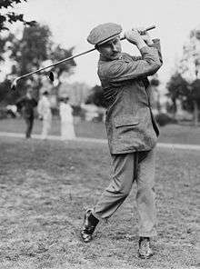
Bury Golf Club, founded in 1890 as a 9-hole course at Redvales, moved to Unsworth in 1921 where it has an 18-hole course. The clubhouse, known as Unsworth Hall on the 1932 OS map[36] has a room commemorating Harry Vardon who won seven major championships from 1896-1914.[37] Pike Fold Golf Club was founded 1909 and moved to Back o' th' Moss Farm in 1999.[38]
Unsworth Junior Football Club has 12 teams ranging from Under 8s to Under 18s. The teams practice at Hillock, and play in the North Bury Junior Football League, where the Under 18s team plays in the Premier Division.[39]
Castlebrook Community Sports Centre in the grounds of Castlebrook High School has a floodlit astroturf pitch and two sports halls.[40]
References
Notes
- ↑ "Bury Ward population 2011". Retrieved 4 January 2016.
- ↑ Mills 1976, p. 143.
- 1 2 3 Farrer, William; Brownbill, J, eds. (1911), "The parish of Prestwich with Oldham: Pilkington", A History of the County of Lancaster: Volume 5, British History Online, pp. 25–34, retrieved 14 November 2013
- ↑ 1891 Cotton Mills in Radcliffe, Grace's Guide, retrieved 19 December 2013
- ↑ http://www.bbc.co.uk/history/domesday/dblock/GB-380000-405000/page/6
- ↑ Unsworth Township Boundaries, genuki.org.uk, retrieved 14 November 2013
- 1 2 3 Lewis, Samuel (1848), "Unsworth", A Topographical Dictionary of England, British History Online, pp. 414–418, retrieved 14 November 2013
- ↑ Greater Manchester Gazetteer, Greater Manchester County Record Office, archived from the original on 18 July 2011, retrieved 17 June 2008
- ↑ Hollins Vale LNR, Bury Council, retrieved 20 December 2013
- ↑ Hollins Vale Local Nature Reserve (pdf), Bury Council, retrieved 20 December 2013
- ↑ Sites of Biological Importance (SBI), Bury Council, retrieved 20 December 2013
- ↑ Unsworth CP: Total Population, A Vision of Britain through Time, retrieved 19 November 2013
- ↑ St George, Unsworth - Church of England, genuki.org, retrieved 14 December 2013
- ↑ St. George's Church, Unsworth (pdf), Ecclesiastical Law Society, retrieved 20 December 2013
- ↑ http://www.old-maps.co.uk/maps.html?coords=381938,407616/ 1891-1893 Pre-WWII 1:2,500 - LANCASHIRE AND FURNESS
- ↑ http://www.genuki.org.uk/big/eng/LAN/Unsworth/HollinsLaneWesleyanMethodist.shtml
- ↑ Unsworth Pole War Memorial, roll-of-honour.com, retrieved 14 November 2013
- ↑ http://www.librarytechnology.org/lwc-displaylibrary.pl?RC=32518
- ↑ http://www.librarytechnology.org/libraries.pl?OrgName=Bury%20Libraries
- ↑ http://www.burytimes.co.uk/yoursay/8762622.Saddened_by_decision_to_sell_our_great_library/
- ↑ http://www.thisislancashire.co.uk/news/8803045.Library_saved_from_closure/
- ↑ http://www.manchestereveningnews.co.uk/news/greater-manchester-news/elbow-frontman-guy-garvey-backs-851598
- ↑ http://www.burytimes.co.uk/news/8803045.Library_saved_from_closure/
- ↑ http://www.ofsted.gov.uk/inspection-reports/find-inspection-report/provider/ELS/105363
- ↑ http://www.ofsted.gov.uk/provider/files/833287/urn/105363.pdf
- ↑ http://unsworth-primary.co.uk/contact.php
- ↑ http://schooletc.co.uk/school-unsworth-primary-school-105317
- ↑ http://www.sunnybankprimary.org.uk/home
- ↑ http://www.hollinsgrundy.ik.org/p_About_Us.ikml
- ↑ http://www.findajewishschool.co.uk/jewish-primary-schools/bury-and-whitefield-jewish-primary-school.php
- ↑ Unsworth Dragon, Mysterious Britain, retrieved 19 December 2013
- ↑ Barton 1973, p. 273.
- ↑ http://www.bbc.co.uk/history/domesday/dblock/GB-380000-405000/page/19
- ↑ Pub blast family's miracle escape, The Bolton News, 24 March 1998, retrieved 19 December 2013
- ↑ Unsworth Cricket Club, Unsworth Cricket Club, retrieved 14 November 2013
- ↑ Lancashire Sheet 96.01 Unsworth & SE Radcliffe 1932, Alan Godfrey Maps, retrieved 14 November 2013
- ↑ Bury Cricket Club, Bury Golf Club, retrieved 14 November 2013
- ↑ Pike Fold Golf Club, Pike Fold Golf Club, retrieved 14 November 2013
- ↑ Unsworth Junior Football Club, Unsworth Junior Football Club, retrieved 14 November 2013
- ↑ http://www.bury.gov.uk/index.aspx?articleid=6594
Bibliography
External links
| Wikimedia Commons has media related to Unsworth. |