University Heights, Newark
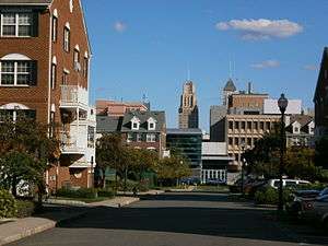
University Heights is an neighborhood in Newark in Essex County, New Jersey, United States. It is so named because of the location of four academic institutions within its boundaries — Rutgers University (Newark Campus), the New Jersey Institute of Technology (NJIT), the New Jersey Medical School (Rutgers), and Essex County College. In total, the schools enroll approximately 40,000 degree-seeking students.
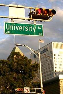
The University Heights neighborhood is roughly bounded by Central Avenue to the north, Bergen Street to the west, South Orange Avenue to the south, and University Avenue to the east. The schools are involved in the development of University Heights Science Park, a major research complex to be located between their campuses.[1][2] Home to Science Park High School as well, the neighborhood is served by the Washington Street, Warren Street/NJIT, and Norfolk Street stations of Newark's Light Rail which links to Manhattan via the PATH and NJTransit rail systems at Newark's Penn Station.
Rutgers and NJIT were expanded considerably beginning in the 1960s. Prior to this expansion, University Heights was a relatively affluent residential neighborhood of Newark. The area has one of Newark's few concentrations of brownstones. The gym at Essex County College was home of the American Basketball Association team, the Newark Express, which moved to Drew University and became the Jersey Express after averaging some 150 fans per game in Newark, though it attracted even fewer at Drew.[3] The area is home to the Paul Robeson Galleries at Rutgers University[4] and the Weston Museum in the Van Houten Library at NJIT, which includes artifacts from inventor Edward Weston, an early challenger of Thomas Edison.[5]
One of the main north-south thoroughfares of University Heights is Martin Luther King, Jr. Blvd. (formerly High Street) which holds many of Newark's historic buildings. Eberhardt Hall at NJIT, St. Mary's Abbey Church, Essex County Hall of Records, and Essex County Courthouse are among Newark's registered historic places, as is the former Essex County Jail.[6]
History
Before the expansion of the universities in the 1960s, the area was pretty affluent and home to many brownstones (as evidenced by the nearby James Street Historic District Downtown). University Avenue was formerly known as Plane Street, as seen in the Washington Street Subway Station where signage directs riders to "Plane Street". High Street, one of the main streets, was renamed Dr. Martin Luther King Jr. Blvd in honor of the civil rights leader .
New development
After the riots in 1967, the University Heights area fell into sharp decline (as with many neighboring areas in the city). Revitalization came through the expansion of all 4 universities/colleges in its boundaries; K. Hovnanian's Society Hill, a market-rate, 13 acre townhouse development just behind UMDNJ and expansion of nearly all the high schools. Recently, the Essex County Parks Commission created and built Veterans Memorial Park on the former site of a parking garage, as part of a renovation of the adjacent county complex, which itself was upgraded with a new parking deck, Streetscape improvements, walking paths and various building upgrades to the Hall of Records, Essex County Court House and former jail, creating a more curb appealing entrance to Downtown Newark.
Baxter Park, a mixed-use development started in July 2011 that will include 400 apartment units along with shopping and recreation space, will replace the 500 units in the original Baxter Terrace development, which was demolished starting in 2008.[7][8]
Education
Colleges and universities
- New Jersey Institute of Technology
- Rutgers–Newark
- Rutgers Biomedical and Health Sciences (Formerly University of Medicine and Dentistry of New Jersey)
- Essex County College

High schools
The neighborhood is also home to many high schools (public and private) including:
Public
- Central High School (moved south to a new campus in the Springfield/Belmont neighborhood)
- Newark Arts High School
- Newark Tech High School
- Science Park High School (Built in 2006)
Private
- Saint Benedict's Preparatory School, all-boys prep school
- Saint Vincent Academy, all-girls prep school
- St. Patricks School
See also
References
- ↑ Garbarine, Rachelle. "In the Region/New Jersey; Newark's Science Park Takes Another Step Forward", The New York Times, November 23, 1997. Accessed April 16, 2012. "WITH $60 million in state financing and leases from three tenants in place, plans are moving forward on a 161,600-square-foot medical research building that will anchor the second phase of development at the 50-acre University Heights Science Park in Newark's Central Ward."
- ↑ Economic and Community Development Initiatives, University of Medicine and Dentistry of New Jersey. Accessed April 16, 2012.
- ↑ Santiago, Katherine. "Jersey Express to play at East Orange high school gym for upcoming season", The Star-Ledger, August 26, 2009. Accessed April 16, 2012 ."The Express moved in 2007 to Morris County after two years in Newark as the Newark Express. Team officials hoped for a surge in attendance above the average 150 fans a game they drew at Essex County College."
- ↑ Paul Robeson Galleries, Rutgers University. Accessed April 16, 2012.
- ↑ The Weston Museum, New Jersey Institute of Technology. Accessed April 16, 2012.
- ↑ "New Jersey and National Registers of Historic Places – Essex County" (PDF). NJ DEP – Historic Preservation Office. November 10, 2010. p. 3. Archived from the original (PDF) on March 27, 2009. Retrieved May 13, 2010.
- ↑ Giambusso, David. "Newark's Baxter Terrace to be replaced with housing, retail space, park in $130M project", The Star-Ledger, July 14, 2011. Accessed February 15, 2012. "Ground was broken today on the first phase of 'Baxter Park,' which will bring housing, retail space and parkland to the Central Ward.The $130 million project, between Broad Street Station, NJIT, Street Michael’s Hospital and Route 280 will replace the 70-year-old, 502-unit complex now being demolished. Fewer than 400 units will go up in their stead and not all will be affordable for low-income residents."
- ↑ Delgado, Samule (February 3, 2012). "Newark could be a real college town". NJ.com. Retrieved 2013-12-08.
External links
Municipalities and communities of Essex County, New Jersey, United States | ||
|---|---|---|
| Cities | 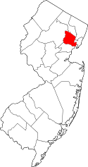 | |
| Boroughs | ||
| Townships | ||
| CDPs and planned communities | ||
Coordinates: 40°44′28″N 74°10′59″W / 40.74111°N 74.18306°W