Unity Village, Missouri
| Unity Village, Missouri | |
|---|---|
| Village | |
|
Unity Church headquarters | |
 Location of Unity Village, Missouri | |
 U.S. Census Map | |
| Coordinates: 38°56′47″N 94°23′58″W / 38.94639°N 94.39944°WCoordinates: 38°56′47″N 94°23′58″W / 38.94639°N 94.39944°W | |
| Country | United States |
| State | Missouri |
| County | Jackson |
| Area[1] | |
| • Total | 1.97 sq mi (5.10 km2) |
| • Land | 1.90 sq mi (4.92 km2) |
| • Water | 0.07 sq mi (0.18 km2) |
| Elevation | 935 ft (285 m) |
| Population (2010)[2] | |
| • Total | 99 |
| • Estimate (2012[3]) | 77 |
| • Density | 52.1/sq mi (20.1/km2) |
| Time zone | Central (CST) (UTC-6) |
| • Summer (DST) | CDT (UTC-5) |
| ZIP codes | 64065 |
| Area code(s) | 816 |
| FIPS code | 29-75202[4] |
| GNIS feature ID | 0728064[5] |
Unity Village is a village in Jackson County, Missouri, United States. The population was 99 at the 2010 census. The village is the world headquarters of Unity, which has over 2 million followers.
Geography
Unity Village is located 15 miles (24.1 km) southeast of downtown Kansas City, Missouri
Unity Village is located at 38°56′47″N 94°23′58″W / 38.94639°N 94.39944°W (38.946283, -94.399311).[6]
According to the United States Census Bureau, the village has a total area of 1.97 square miles (5.10 km2), of which, 1.90 square miles (4.92 km2) of it is land and 0.07 square miles (0.18 km2) is water.[1]
Tornado
On July 1, 2015 a tornado ripped roofs to shreds. However, it only lasted a few seconds.
Demographics
| Historical population | |||
|---|---|---|---|
| Census | Pop. | %± | |
| 1960 | 153 | — | |
| 1970 | 242 | 58.2% | |
| 1980 | 202 | −16.5% | |
| 1990 | 138 | −31.7% | |
| 2000 | 140 | 1.4% | |
| 2010 | 99 | −29.3% | |
| Est. 2015 | 84 | [7] | −15.2% |
2010 census
As of the census[2] of 2010, there were 99 people, 65 households, and 11 families residing in the village. The population density was 52.1 inhabitants per square mile (20.1/km2). There were 73 housing units at an average density of 38.4 per square mile (14.8/km2). The racial makeup of the village was 85.9% White, 7.1% African American, 2.0% Asian, and 5.1% from two or more races. Hispanic or Latino of any race were 6.1% of the population.
There were 65 households of which 7.7% had children under the age of 18 living with them, 9.2% were married couples living together, 4.6% had a female householder with no husband present, 3.1% had a male householder with no wife present, and 83.1% were non-families. 73.8% of all households were made up of individuals and 16.9% had someone living alone who was 65 years of age or older. The average household size was 1.32 and the average family size was 2.36.
The median age in the village was 52.5 years. 6.1% of residents were under the age of 18; 5% were between the ages of 18 and 24; 17.2% were from 25 to 44; 55.6% were from 45 to 64; and 16.2% were 65 years of age or older. The gender makeup of the village was 34.3% male and 65.7% female.
2000 census
As of the census[4] of 2000, there were 140 people, 81 households, and 19 families residing in the village. The population density was 73.6 people per square mile (28.4/km²). There were 82 housing units at an average density of 43.1 per square mile (16.7/km²). The racial makeup of the village was 94.29% White, 2.86% African American, 0.71% Asian, 0.71% from other races, and 1.43% from two or more races. Hispanic or Latino of any race were 5.71% of the population.
There were 81 households out of which 2.5% had children under the age of 18 living with them, 18.5% were married couples living together, 3.7% had a female householder with no husband present, and 76.5% were non-families. 71.6% of all households were made up of individuals and 21.0% had someone living alone who was 65 years of age or older. The average household size was 1.35 and the average family size was 2.21.
In the village the population was spread out with 2.1% under the age of 18, 7.9% from 18 to 24, 31.4% from 25 to 44, 42.9% from 45 to 64, and 15.7% who were 65 years of age or older. The median age was 50 years. For every 100 females there were 62.8 males. For every 100 females age 18 and over, there were 63.1 males.
The median income for a household in the village was $29,583, and the median income for a family was $87,667. Males had a median income of $41,765 versus $30,667 for females. The per capita income for the village was $31,836. There were none of the families and 11.9% of the population living below the poverty line, including no under eighteens and none of those over 64.
References
- 1 2 "US Gazetteer files 2010". United States Census Bureau. Archived from the original on January 24, 2012. Retrieved 2012-07-08.
- 1 2 "American FactFinder". United States Census Bureau. Retrieved 2012-07-08.
- ↑ "Population Estimates". United States Census Bureau. Archived from the original on June 17, 2013. Retrieved 2013-05-30.
- 1 2 "American FactFinder". United States Census Bureau. Archived from the original on September 11, 2013. Retrieved 2008-01-31.
- ↑ "US Board on Geographic Names". United States Geological Survey. 2007-10-25. Retrieved 2008-01-31.
- ↑ "US Gazetteer files: 2010, 2000, and 1990". United States Census Bureau. 2011-02-12. Retrieved 2011-04-23.
- ↑ "Annual Estimates of the Resident Population for Incorporated Places: April 1, 2010 to July 1, 2015". Retrieved July 2, 2016.
- ↑ "Census of Population and Housing". Census.gov. Archived from the original on May 11, 2015. Retrieved June 4, 2015.
External links
- Village website
- Headquarters for Unity Worldwide
- The Association of Unity Churches
- http://www.lstourism.com/unity.htm
| Founders | 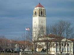 | |
|---|---|---|
| People |
| |
| Background |
| |
| Other | ||
Municipalities and communities of Jackson County, Missouri, United States | ||
|---|---|---|
| Cities | 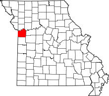 | |
| Villages | ||
| Townships | ||
| Unincorporated communities | ||
| Footnotes | ‡This populated place also has portions in an adjacent county or counties | |
Kansas City metropolitan area's cities and counties | ||
|---|---|---|
| Central city |  | |
| Largest cities (over 100,000 in 2000) | ||
| Medium-sized cities (10,000 to 100,000 in 2000) | ||
| Smaller Cities (between 5,000 and 9,900 in 2010) | ||
| Counties | ||