United States Space Surveillance Network
The United States Space Surveillance Network detects, tracks, catalogs and identifies artificial objects orbiting Earth, e.g. active/inactive satellites, spent rocket bodies, or fragmentation debris. The system is the responsibility of the Joint Functional Component Command for Space, part of the United States Strategic Command (USSTRATCOM).
Space surveillance accomplishes the following:
- Predict when and where a decaying space object will re-enter the Earth's atmosphere;
- Prevent a returning space object, which to radar looks like a missile, from triggering a false alarm in missile-attack warning sensors of the U.S. and other countries;
- Chart the present position of space objects and plot their anticipated orbital paths;
- Detect new man-made objects in space;
- Correctly map objects travelling in the Earth's orbit;
- Produce a running catalog of man-made space objects;
- Determine which country owns a re-entering space object;
- Inform NASA whether or not objects may interfere with satellites and International Space Station orbits.
The SPACETRACK program represents a worldwide Space Surveillance Network (SSN) of dedicated, collateral, and contributing electro-optical, passive radio frequency (RF) and radar sensors. The SSN is tasked to provide space object cataloging and identification, satellite attack warning, timely notification to U.S. forces of satellite fly-over, space treaty monitoring, and scientific and technical intelligence gathering. The continued increase in satellite and orbital debris populations, as well as the increasing diversity in launch trajectories, non-standard orbits, and geosynchronous altitudes, necessitates continued modernization of the SSN to meet existing and future requirements and ensure their cost-effective supportability.[1]
SPACETRACK also developed the systems interfaces necessary for the command and control, targeting, and damage assessment of a potential future U.S. anti-satellite weapon (ASAT) system. There is an Image Information Processing Center and Supercomputing facility at the Air Force Maui Optical Station (AMOS). The resources and responsibility for the HAVE STARE Radar System development were transferred to SPACETRACK from an intelligence program per Congressional direction in FY93.
History
1957–1963
The first formalized effort to catalog satellites occurred at Project Space Track, later known as the National Space Surveillance Control Center (NSSCC), located at Hanscom Field in Bedford, Massachusetts. The procedures used at the NSSCC were first reported in 1959 and 1960 by Wahl,[2] who was the technical director of the NSSCC. In 1960, under Project Space Track, Fitzpatrick and Findley developed detailed documentation of the procedures used at the NSSCC.[3] For the early history of satellite tracking, 1957–1961, see Project Space Track.
Early Space Track observations of satellites were collected at more than 150 individual sites, including radar stations, Baker–Nunn cameras, telescopes, radio receivers, and the Operation Moonwatch participants. Individuals at these Moonwatch sites took manual observations on satellites by visual means, but there were numerous observation types and sources, some automated, some only semi-automated. The observations were transferred to the NSSCC by teletype, telephone, mail, and personal messenger. There, a duty analyst reduced the data and determined corrections that should be made to the orbital elements before they were used for further predictions. After this analysis, the corrections were fed into an IBM 709 computer that computed the updated orbital data. The updated orbital data were then used in another phase of the same computer program to yield the geocentric ephemeris. From the geocentric ephemeris, three different products were computed and sent back to the observing stations for their planning of future observing opportunities.[3]
Missile Warning and Space Surveillance in the Eisenhower Years
The launch of Sputnik 1 triggered a need for tracking of objects in space using the Space Tracking System. The first US system, Minitrack, was already in existence at the time of the Sputnik launch, but the US quickly discovered that Minitrack could not reliably detect and track satellites. The US Navy designed Minitrack to track the Vanguard satellite, and so long as satellites followed the international agreement on satellite transmitting frequencies, Minitrack could track any satellite. However, the Soviets chose not to use the international satellite frequencies. Thus, a major limitation of this system became visible. Minitrack could not detect or track an uncooperative or passive satellite.[4]
Concurrent with Minitrack was the use of the Baker-Nunn satellite tracking cameras. These systems used modified Schmidt telescopes of great resolution to photograph and identify objects in space. The cameras first became operational in 1958 and eventually operated at sites worldwide. At their peak, the Air Force ran five sites, the Royal Canadian Air Force ran two, and the Smithsonian Institution's Astrophysics Observatory operated a further eight sites. The Baker-Nunn system, like Minitrack, provided little real-time data and was additionally limited to night-time, clear weather operations.[4]
Beyond the problems in acquiring data on satellites, it became obvious that the US tracking network would soon be overwhelmed by the tremendous number of satellites that followed Sputnik and Vanguard. The amount of satellite tracking data accumulated required creation or expansion of organizations and equipment to sift through and catalog the objects. The need for real-time detection and tracking information to deal with Soviet satellite launches led on 19 December 1958 to ARPA's implementation of Executive Order 50-59 to establish a spacetrack network. This spacetrack network, Project Shepherd, began with the Space Track Filter Center at Bedford, Massachusetts, and an operational space defense network (i.e., a missile warning network). ARDC took up the spacetrack mission in late 1959 and in April 1960 set up the Interim National Space Surveillance Control Center at Hanscom Field, Massachusetts, to coordinate observations and maintain satellite data.(96) At the same time, DOD designated the Aerospace Defense Command (ADCOM), formerly Air Defense Command, as the prime user of spacetrack data. ADCOM formulated the first US plans for space surveillance.[4]
During the years that intercontinental ballistic missiles were developing as frontline weapon systems, numerous missile detection and warning sensors were being experimented with and fielded as operational sensors and most of these contributed satellite observation data at one time or another. Many have been overlooked by current histories and additional research is merited. Among these were two Trinidad detection and tracking radars; Laredo, Texas; and Moorestown, New Jersey. Additional sensors that performed or contributed to space tracking but are not yet included in this page include mechanical tracking radars on the islands of Kaena Point, Antigua, Ascension, San Miguel, and Kwajalein Atoll; the three BMEWS sites; the Pave Paws sites; the FSS-7 sites; the passive (PASS) sites; Cavalier ND; Eglin FL; Maui Space Surveillance System; Globus II; San Vito; TOSS/CROSS; and MIT Lincoln Laboratory.
Air Force Space Surveillance System
The Air Force Space Surveillance System (AFSSS), also known as the "space fence", was a very high frequency radar network located at sites across the southern United States (from California to Georgia) with a centralized data processing site at the Naval Network and Space Operations Command in Dahlgren, Virginia. AFSSS began as the Navy's Space Surveillance (SPASUR) system in 1961 (later renamed NAVSPASUR). It was transferred to the Air Force in 2004 and renamed AFSSS. The "fence" was operated by the U.S. Air Force (20th Space Control Squadron Detachment 1).
The Satellite Detection and Reconnaissance Defense (the former designation of the NSSS) reached initial operating capability in 1961. The role of the "fence" grew. The system detected space objects from new launches, maneuvers of existing objects, breakups of existing objects, and provided data to users from its catalog of space objects. Orbital parameters of more than 10,000 objects were maintained in this catalog—which has now gained usage by NASA, weather agencies, and friendly foreign agencies. The information is essential to computing the collision avoidance information to de-conflict launch windows with known orbiting space objects.
The 21st Space Wing closed the Air Force Space Surveillance System on 1 October 2013 citing resource constraints caused by sequestration.[5]
US Space Catalog
The United States Department of Defense (DoD) has maintained a database of satellite states since the launch of the first Sputnik in 1957, known as the Space Object Catalog, or simply the Space Catalog. These satellite states are regularly updated with observations from the Space Surveillance Network, a globally distributed network of interferometer, radar and optical tracking systems. Two separate catalog databases are maintained under the USSTRATCOM: a primary catalog by the Air Force Space Command (AFSPC), and an alternate catalog by the Naval Space Command (NSC). By the year 2001, the number of cataloged objects was nearly 20,000.[6][7][8]
Different astrodynamics theories are used to maintain these catalogs. The General Perturbations (GP) theory provides a general analytical solution of the satellite equations of motion. The orbital elements and their associated partial derivatives are expressed as series expansions in terms of the initial conditions of these differential equations. The GP theories operated efficiently on the earliest electronic computing machines, and were therefore adopted as the primary theory for Space Catalog orbit determination. Assumptions must be made to simplify these analytical theories, such as truncation of the Earth’s gravitational potential to a few zonal harmonic terms. The atmosphere is usually modeled as a static, spherical density field that exponentially decays. Third body influences and resonance effects are partially modeled. Increased accuracy of GP theory usually requires significant development efforts.[6]
NASA maintains civilian databases of GP orbital elements, also known as NASA or NORAD two-line elements. The GP element sets are "mean" element sets that have specific periodic features removed to enhance long-term prediction performance, and require special software to reconstruct the compressed trajectory.[6]
Shemya and Diyarbakir Radar Sites
AN/FPS-17 and AN/FPS-80 radars placed at Shemya in the 1960s to track Soviet missile tests and to support the Air Force Spacetrack System. In July 1973, Raytheon won a contract to build a system called "Cobra Dane" on Shemya Island in the Aleutian Islands off the Alaskan coast. Designated as the AN/FPS-108, Cobra Dane replaced AN/FPS-17 and AN/FPS-80 radars. Becoming operational in 1977, Cobra Dane also had a primary mission of monitoring Soviet tests of missiles launched from southwest Russia aimed at the Siberian Kamchatka peninsula. This large, single-faced, phased-array radar was the most powerful ever built.
The FPS-80 was a tracking radar and the FPS-17 was a detection radar for Soviet missiles. Both were part of the Ballistic Missile Early Warning System (BMEWS). The large detection radar (AN/FPS-17) went into operation in 1960. In 1961, the AN/FPS-80 tracking radar was constructed nearby. These radars were closed in the 1970s.
The Pirinclik (near Diyarbakir, Turkey) intelligence collection radar site ultimately consisted of one detection radar (FPS-17) and one mechanical tracking radar (FPS-79). The Pirinclik radars were operated by the 19th Surveillance Squadron. The FPS-17 radar reached IOC on 1 June 1955 and the FPS-79 in 1964. Both radars operated at a UHF (432 MHz) frequency. Although limited by their mechanical technology, Pirinclik's two radars gave the advantage of tracking two objects simultaneously in real time. Its location close to the southern Former Soviet Union made it the only ground sensor capable of tracking actual deorbits of Russian space objects. In addition, the Pirinclik radar was the only 24-hour-per-day eastern hemisphere deep space sensor. Radar operations at Pirinclik were terminated in March 1997.
AN/FPS-17
With the Soviet Union apparently making rapid progress in its rocket program, in 1954 the United States began a program to develop a long range surveillance radar. General Electric Heavy Military Electronics Division (HMED) in Syracuse, NY was the prime contractor and Lincoln Laboratory was a subcontractor. This tracking radar, the AN/FPS-17, was conceived, designed, built, and installed for operation in nine months.[9][10][11] The first installation, designated AN/FPS-17(XW-1) was at Diyarbakir (Pirinclik), Turkey, to detect Soviet launches. A second system, designated AN/FPS-17(XW-2), was installed at Laredo AFS (about 7 miles (11 km) northeast of Laredo AFB) in Texas, to track rockets launched from White Sands, New Mexico, and serve as a radar test bed. A third system, designated AN/FPS-17(XW-3), was installed on Shemya Island, Alaska, to detect Soviet launches. The Diyarbakir FPS-17 became operational in June 1955, the Laredo installation in February 1956, and Shemya in May 1960.[9][10][11][12] The first two installations closed without replacements; the Shemya installation was replaced by the Cobra Dane (AN/FPS-108) radar.[13]
The FPS-17 antenna featured a fixed parabolic torus section reflector that typically stood 175 feet (53 m) high and 110 feet (34 m) wide and was illuminated by an array of radar feed horns placed in front of it. The transmitters operated in the VHF band, sending out pulses at frequencies between approximately 180 to 220 MHz.[14] The FPS-17 was unique in that, unlike most radar types, each site’s version differed from the other sites. Differences included transmitter equipment, reflector size and number, and the number and arrangement of feed horns. Additionally, the FPS-17 was the first operational radar system to employ pulse compression techniques.[15] There were two AN/FPS-17 antennas at Diyarbakir, Turkey, one antenna at Laredo, and three at Shemya in the Aleutians.[9] [14]
AN/FPS-79
The original FPS-79 antenna at Diyarbakir had a unique feature which enhanced its Spacetrack usefulness. A variable-focus feed horn provided a wide beam for detection and a narrow beamwidth for tracking. That antenna was replaced by a new antenna and pedestal in 1975. Pulse compression was used to improve both the gain and resolution of the 35-foot (11 m) dish antenna. Steering was mechanical; the FPS-79 had a range of 24,000 miles (39,000 km). The radar site closed in 1997.
After circling the Earth in an apparently dormant state for 9 months, on November 13, 1986 the SPOT 1 Ariane third stage violently separated into some 465 detectable fragments - the most severe satellite breakup yet recorded prior to 2007.
Although the debris cloud did not pass over the continental United States until more than 8 hours later, personnel in the Space Surveillance Center (SSC) at the Cheyenne Mountain Complex in Colorado Springs, Colorado reported that the U.S. FPS-79 radar at Pirinclik, Turkey, noticed the debris within minutes of the fragmentation.[16]
Blue Nine and Blue Fox
Blue Nine refers to a project which produced the AN/FPS-79 Tracking Radar Set built by General Electric, used with the 466L Electromagnetic Intelligence System (ELINT); US Air Force. Blue Fox refers to a modification of the AN/FPS-80 tracking radar to the AN/FPS-80(M) configuration. Shemya, AK, 1964. Both of these systems incorporated GE M236 computers.
AN/FPS-80
A 60-foot dish mechanical tracking radar built by General Electric. Deployed at Shemya Island, Alaska, as a UHF radar and upgraded to L-Band in 1964. Used as tracker radar for Spacetrack network measurements once target detected. Principally used for intelligence purposes to track Russian missiles. The advanced FPS-108 Cobra Dane phased array radar replaced the FPS-17 and FPS-80 radars in 1977.
Space Surveillance Network

The command accomplishes these tasks through its Space Surveillance Network (SSN) of U.S. Army, Navy and Air Force operated, ground-based radars and optical sensors at 25 sites worldwide.
The SSN has been tracking space objects since 1957 when the Soviet Union opened the space age with the launch of Sputnik I. Since then, the SSN has tracked more than 39,000 space objects orbiting Earth. Of that number, the SSN currently tracks more than 8,000 orbiting objects. The rest have re-entered Earth's turbulent atmosphere and disintegrated, or survived re-entry and impacted the Earth. The space objects now orbiting Earth range from satellites weighing several tons to pieces of spent rocket bodies weighing only 10 pounds (4.5 kg).
About seven percent of the space objects are operational satellites, the rest are debris. The USSTRATCOM is primarily interested in the active satellites, but also tracks space debris. The SSN tracks space objects which are 10 centimeters in diameter (baseball size) or larger.
The Space Surveillance Network has numerous sensors that provide data. They are separated in three categories: dedicated sensors, collateral sensors and auxiliary sensors. Both the dedicated and collateral sensors are operated by the USSPACECOM, but while the former have a primary objective to acquire SSN data, the latter obtain SSN data as a secondary objective. The auxiliary sensors are not operated by the USSPACECOM and usually perform space surveillance collaterally. Additionally sensors are classified as Near-Earth (NE) tracking - observing satellites, space debris and other objects in lower orbits, or Deep Space (DS) - generally for asteroids and comets.
- Dedicated sensors
- Ground-based Electro-Optical Deep Space Surveillance (GEODSS) sites
- Space Surveillance Telescope (SST)
- MOSS - an Electro-Optical (E-O) surveillance system located at the Moron Air Base, Spain
- GLOBUS II radar
- AN/FPS-85 Space Track Radar
- AN/FPS-133 Air Force Space Surveillance System, also known as the Space Fence and its replacement Space Fence
- Midcourse Space Experiment (MSX) / Space Based Visible (SBV) satellites
- Collateral sensors
- Maui Space Surveillance System (MSSS) and Advanced Electro-Optical System (AEOS) telescope, co-located with a GEODSS station in Maui, Hawaii
- Haystack Ultrawideband Satellite Imaging Radar (HUSIR), Haystack Auxiliary Radar (HAX) and Millstone Hill Radar
- ALTAIR and ALCOR radars at the Ronald Reagan Ballistic Missile Defense Test Site, Kwajalein Atoll
- Ascension Range Radar, locate at the Eastern Spacelift Range
- Ground-Based Radar Prototype (GBR-P), located Ronald Reagan Ballistic Missile Defense Test Site, Kwajalein Atoll
- Auxiliary sensors
- Solid State Phased Array Radar System (SSPARS) / AN/FPS-132 Upgraded Early Warning Radar (UEWR) system of system, deployed at multiple sites
- AN/FPS-108 Cobra Dane
- AN/FPQ-16 Perimeter Acquisition Radar Characterization System (PARCS)
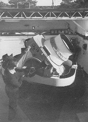
Ground-based Electro-Optical Deep Space Surveillance
_in_Diego_Garcia.jpg)
Ground-based Electro-Optical Deep Space Surveillance, or GEODSS, is an optical system that uses telescopes, low-light level TV cameras, and computers. It replaced an older system of six 20 inch (half meter) Baker-Nunn cameras which used photographic film.
There are three operational GEODSS sites that report to the 21st Operations Group:
- Socorro, New Mexico 33°49′02″N 106°39′36″W / 33.8172°N 106.6599°W
- AMOS, Maui, Hawaii 20°42′32″N 156°15′28″W / 20.7088°N 156.2578°W
- Diego Garcia, British Indian Ocean Territory 7°24′42″S 72°27′08″E / 7.41173°S 72.45222°E.
A site at Choe Jong San, South Korea was closed in 1993 due to nearby smog from the town, weather and cost concerns. Originally, the fifth GEODSS was planned to be operated from a site in Portugal, but this was never built.
Moron Optical Space Surveillance (MOSS), a transportable 22-inch aperture telescope that contributed to the GEODSS system was operational at Morón Air Base, Spain 37°10′12″N 5°36′32″W / 37.170°N 5.609°W from 1997 to 2012.
GEODSS tracks objects in deep space, or from about 3,000 mi (4,800 km) out to beyond geosynchronous altitudes. GEODSS requires nighttime and clear weather tracking because of the inherent limitations of an optical system. Each site has three telescopes. The telescopes have a 40-inch (1.02 m) aperture and a two-degree field of view. The telescopes are able to "see" objects 10,000 times dimmer than the human eye can detect. This sensitivity, and sky background during daytime that masks satellites reflected light, dictates that the system operate at night. As with any ground-based optical system, cloud cover and local weather conditions directly influence its effectiveness. GEODSS system can track objects as small as a basketball more than 20,000 miles (30,000 km) in space or a chair at 35,000 miles (56,000 km), and is a vital part of USSTRATCOM’s Space Surveillance Network. Distant Molniya orbiting satellites are often detected in elliptical orbits that surpass the Moon and back (245,000 miles out). Each GEODSS site tracks approximately 3,000 objects per night out of 9,900 object that are regularly tracked and accounted for. Objects crossing the International Space Station (ISS) orbit within 20 miles (32 km) will cause the ISS to adjust their orbit to avoid collision. The oldest object tracked is Object #4 (Vanguard 1) launched in 1958.
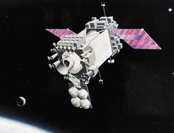
Space Based Visible (SBV) Sensor
The SSN included one spaceborne sensor, the space-based visible (SBV) sensor, carried into orbit aboard the Midcourse Space Experiment (MSX) satellite launched by the Ballistic Missile Defense Organization in 1996. It was retired from service on June 2, 2008.[17]
The Space Based Space Surveillance (SBSS) pathfinder satellite now performs the mission previously handled by the MSX SBV.
See also
- Air Force Space Surveillance System
- Air Force Maui Optical and Supercomputing observatory
- Space Situational Awareness Programme, the European Space Agency's near-Earth object and space debris tracking programme
- Krona space object recognition station and Krona-N, Russian telescope- and radar-based space surveillance facilities
- Okno and Okno-S, Russian telescope-based space surveillance facilities
- Main Space Intelligence Centre, the headquarters of the Russian military's space surveillance network, SKKP
- Kessler syndrome
- Space debris
Notes
References
- ↑ Charles, Charles Ira (1969). Spacetrack, Watchdog of the Skies. New York: William Morrow. p. 128. ISBN 978-0-688-31561-0.
- ↑ Wahl, E[berhart]. W.. Program Development in Orbital Computation at the U.S. National Space Surveillance Control Center. [Proceedings of the Second Symposium (International) on Rockets and Astronautics]. [Tokyo: May 1960.]
- 1 2 Hoots, Felix R.; Paul W. Schumacher Jr.; Robert A. Glover (2004). "History of Analytical Orbit Modeling in the U. S. Space Surveillance System". Journal of Guidance Control, and Dynamics. AIAA. 27 (2): 174–185. Bibcode:2004JGCD...27..174H. doi:10.2514/1.9161. ISSN 0731-5090.
- 1 2 3 Muolo, Maj Michael J. (December 1993). "Space Handbook - A War Fighter's Guide to Space". One. Maxwell Air Force Base: Air University Press.
- ↑ Glaus, Stacy. "End of an era for AFSSS". Peterson Air Force Base. U.S. Air Force. Retrieved 24 March 2014.
- 1 2 3 Neal, H. L.; S.L. Coffey; S.H. Knowles (1997). "Maintaining the Space Object Catalog with Special Perturbations". Astrodynamics. Sun Valley, ID: AAS/AIAA. v.97 (Part II): 1349–1360.
- ↑ Vallado, David (2001). Fundamentals of Astrodynamics and Applications. Torrance: Microcosm Press. p. 958. ISBN 1-881883-12-4.
- ↑ Hoots, Felix R.; Ronald L. Roehrich (December 1980). "SPACETRACK REPORT NO. 3 - Models for Propagation of NORAD Element Sets". Adc/Do6. Peterson AFB: Project Spacetrack Reports, Office of Astrodynamics, Aerospace Defense Center.
- 1 2 3 Progress In Defense and Space, A History of the Aerospace Group of the General Electric Company, Major A. Johnson, 1993, pp262, 287-289.
- 1 2 A Fiery Peace in a Cold War: Bernard Schriever and the Ultimate Weapon, Neil Sheehan, 2009, pp301-311.
- 1 2 "The Diyarbakir Radar", Stanley G. Zabetakis & John F. Peterson, 1964. Studies in Intelligence, Fall 1964 edition, pages 41-47. Declassified.
- ↑ Forty Years of Research and Development at Griffiss Air Force Base, Rome Air Development Center, 1992.
- ↑ Streetly, Martin (2008). Jane's Radar and Electronic Warfare Systems 2008-2009. Coulsdon: Jane's Information Group. p. 670. ISBN 0-7106-2855-2.
- 1 2 NRL Memorandum Report 1637, "Information on Over-the-Horizon Radar", Part VI, 13 August 1965. Declassified.
- ↑ "Radar Development at Lincoln Laboratory: An Overview of the First Fifty Years", William P. Delaney and William W. Ward, Vol.12, No. 2, 2000 Lincoln Laboratory Journal, pp147-166.
- ↑ Johnson, N. L. (1989). "Preliminary analysis of the Fragmentation of the SPOT 1 Ariane Third Stage". Progress in Astronautics and Aeronautics. Washington, DC: AIAA. 121: 41–47.
- ↑ Amy Butler (2008). "Space-Based Visible Sensor Ceases Ops". Aviation Week. Retrieved November 21, 2008.
External links
- The Space-Track website
- U.S. Strategic Command Space Surveillance
- J-Track 3-D displays a globe and orbiting satellites.
- Orbital Debris Quarterly News information on some of the latest events in orbital debris research.
- Air Force Fact Sheet at Archive.is (archived 2012-07-21)
- A GEODSS Sourcebook
| |||||||||||||||||||||||
| Leadership | |||||||||||||||||||||||
| Organization |
| ||||||||||||||||||||||
| Structure |
| ||||||||||||||||||||||
| Operations and history | |||||||||||||||||||||||
| Personnel |
| ||||||||||||||||||||||
| Equipment |
| ||||||||||||||||||||||
| |||||||||||||||||||||||