Union Chapel, Massachusetts
| Union Chapel, Massachusetts | |
|---|---|
| Village | |
|
750 Podunk Road | |
 Union Chapel, Massachusetts | |
| Coordinates: 42°11′03″N 72°02′00″W / 42.18417°N 72.03333°WCoordinates: 42°11′03″N 72°02′00″W / 42.18417°N 72.03333°W | |
| Country | United States |
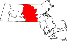
| State | Massachusetts |
| County | Worcester |
| Elevation | 745 ft (227 m) |
| Time zone | Eastern (EST) (UTC-5) |
| • Summer (DST) | EDT (UTC-4) |
| Area code(s) | 508 & 774 |
| GNIS feature ID | 609856[1] |

Union Chapel is a village in the town of East Brookfield, Worcester County, Massachusetts, United States.[1]
Notes
This article is issued from Wikipedia - version of the 10/23/2014. The text is available under the Creative Commons Attribution/Share Alike but additional terms may apply for the media files.