Unfinished Pyramid of Abusir
| Unfinished Pyramid of Abusir | |
|---|---|
| Shepseskare (?) | |
| Constructed | 5th Dynasty |
| Type | True pyramid |
| Base | 105 m (?) |
| Slope | unknown |
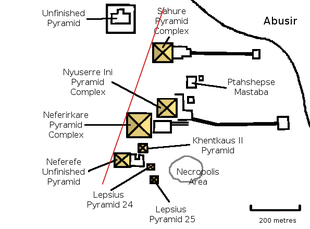
The Unfinished Pyramid of Abusir is an ancient Egyptian royal tomb which was probably abandoned shortly after the start of construction in the 5th Dynasty, which is located in the necropolis of Abusir. Shepseskare, a Pharaoh about whom almost nothing is known, who is known only from a single roughly contemporary seal impression from the mortuary temple of Neferefre, has been suggested as the pyramid's builder.
Exploration
The structure was first discovered at the beginning of the 1980s by a Czech archaeological team led by Miroslav Verner, which noticed the levelled ground and the pit. Additional elements of the complex could not be found.[1]
Date
The site cannot be directly connected with any ruler, since the few finds from the site did not include any inscriptions. An inferential assignment to Shepseskare is based on the location of the site in the necropolis. Because of the proximity of the area to the Pyramid of Sahure and the Sun Temple of Userkaf, Verner suggested that Shepseskare belonged to the same branch of the royal family as these two rulers.[1][2]
The chronological position of Shepseskare is not entirely clear. While Manetho lists him in the Aegyptiaca as a successor of Neferirkare, the discovery of a seal impression in the Mortuary temple of Neferefre suggests that he was Neferefre'ssuccessor and completed his sun temple.[3] The arrangement as successor of Neferefre is consistent with the fact that Neferefre was able to begin construction on the same orientation towards Heliopolis, while for his successors this was no longer possible due to space limitations.
Construction
When Shepseskare came to power, there were already three pyramids in the necropolis of Abusir. These were arranged with their northwest corners in a line, probably pointing to the obelisk of Heliopolis (the so-called "Abusir Diagonal"). To maintain this orientation, Shepseskare would have had to erect his pyramid even further into the desert than the unfinished Pyramid of Neferefre, which would have made the transport of materials difficult. Instead he chose an area northwest of the Pyramid of Sahure, halfway to the Sun Temple of Userkaf, as his building site.[1][2]
Shepseskare died after only a short reign, which led to the abandonment of construction. His successor Niuserre did not carry out any further work on this tomb. The location of Shepseskare's interment is unknown, but it is assumed that he was not buried in this barely started tomb.
Pyramid
Construction of the actual pyramid structure was never begun. Only the levelling of the terrain to a flat, square area was carried out. In the middle of the levelled area is a T-shaped pit, in which the burial chamber and its entranceway would have been installed.[1][2]
The dimensions of the levelled area and the pit allow it to be suggested that the building would have been a similar size to the Pyramid of Neferirkare (105 m x 105 m) and thus that it was planned to be the second largest tomb at Abusir, after the pyramid of Neferirkare. The ctual dimensions are not recoverable, since stonework had not yet been installed. Additionally, the slope of the sides and thus the planned height is unknowable due to the lack of cladding stones.[2]
Remains of a pyramid complex including the traditional elements of the mortuary temple, temenos wall, cult pyramid, causeway and valley temple were not found. These components were probably never begun, since they would have got in the way of the building work on the pyramid during the early stages of construction.
References
- 1 2 3 4 Rainer Stadelmann. Die ägyptischen Pyramiden. Vom Ziegelbau zum Weltwunder. p. 175
- 1 2 3 4 Miroslav Verner. Die Pyramiden. pp. 345–346
- ↑ Miroslav Verner. "Archaeological Remarks on the 4th and 5th Dynasty Chronology." Archiv Orientální, Vol. 69, Prag 2001, p. 396 (PDF; 31 MB)
Bibliography
General
- Rainer Stadelmann. Die ägyptischen Pyramiden. Vom Ziegelbau zum Weltwunder. 3rd Edition, von Zabern, Mainz 1997, ISBN 3-8053-1142-7, p. 175.
- Miroslav Verner. Die Pyramiden. Rowohlt, Reinbek 1998, ISBN 3499608901, pp. 345–346.
Excavation reports
- Miroslav Verner. "Eine zweite unvollendete Pyramide in Abusir." Zeitschrift für Ägyptische Sprache und Altertumskunde. (ZÄS) Vol. 109, 1982, pp. 75–78.
| |||||||||||||||
| Old Kingdom (2686–2181 BC) |
| ||||||||||||||
| 1st Intermediate Period (2181–2040 BC) |
| ||||||||||||||
| Middle Kingdom (2040–1650 BC) |
| ||||||||||||||
| Second Intermediate (1650–1570 BC) |
| ||||||||||||||
| New Kingdom (1570–1070 BC) |
| ||||||||||||||
Coordinates: 29°53′55″N 31°12′6″E / 29.89861°N 31.20167°E