Una district
| Una district | |
|---|---|
| District of Himachal Pradesh | |
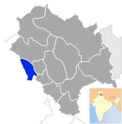 Location of Una district in Himachal Pradesh | |
| Country | India |
| State | Himachal Pradesh |
| Headquarters | Una, Himachal Pradesh |
| Tehsils |
5  |
| Government | |
| • Lok Sabha constituencies | 5 |
| Area | |
| • Total | 1,549 km2 (598 sq mi) |
| Population (2011) | |
| • Total | 5,21,057 |
| • Density | 340/km2 (870/sq mi) |
| • Urban | 8.8% |
| Demographics | |
| • Literacy | 87.23% |
| • Sex ratio | 977 |
| Average annual precipitation | 1253 mm |
| Website | Official website |
Una is one of the districts of Himachal Pradesh, India. District shares its border with the Kangra district and Hamirpur district of Himachal Pradesh and Hoshiarpur district and Ropar district of Punjab. The terrain is generally a plain with low hills. Una has been identified as a main industrial hub and has become a transit town for travellers going to the famous city of Dharamshala or locations within the Himalayas such as Kullu, Manali, Jawalamukhi, and Chintpurni. Una has 5 Tehsils Ghanari, Haroli, Amb, Bangana and Una. Una is home to the Kila, which is a historical fort and an ancestral home of the descendants of the first guru of the Sikhs, Guru Nanak. Una although unchanged for past century has shown huge appetite for growth and development. The City and Urban area is expected to grow at rapid pace amidst the investment coming from native N.R.I community which is huge in number as every household has at least one family member or relative working abroad.
Language
Local languages are Hindi , Pahari and also Punjabi in some areas. While people in areas like Tehsil Ghanari, Haroli use Punjabi in their regular conversation, But in other areas like Bangana, Chintpurni and Amb pahari is spoken. Una had been a tehsil of the Hoshiarpur district until the Punjab Reorganisation Act, 1966. Due to religious contiguity, it was given to Himachal Pradesh.[1]
Attire
Kurta and Pajama is the culturally accepted dress for men. Farmers find Tamba and Kurta particularly comfortable. Office-going men wear shirts and pants. Women wear Salwar Kameez on most casual and formal occasions. A Sari is also worn, especially to weddings. Young people mostly wear western styled clothing: tight-fitted denims, pants; t-shirt, polos and shirts. Unisex clothing is gaining acceptance, especially in the suburbs. Shawl known locally as "Chadru" or "loi" are worn in the winters. They can be plain or embroidered (especially for women).
Population
According to the 2001 census, the total population of Una was 447,967 with a sex-ratio of 997. The literacy rate stood at 81.09%. In 2011, population figures were raised to 521,057 with decreased sex ratio of 977. The literacy rate increased to 87.23%. The total area of the district is 1,549 km2 (598 sq mi). The urban population contributes nearly 9% of the total population. Hinduism is the prominent religion, with Sikhism Christianity and Islam forming minorities.
Geography
Una lies in the southwestern part of Himachal Pradesh, with the beautiful Sivalik hills of the Himalayas gently rolling on one side. The Satluj river passes alongside Shahtalai hills, known for the shrine of Baba Balak Nath.
Una is geograhically one of the most apt and versatile area of Himachal Pradesh with close vicinity to Chandigarh connected by broad gauge railway and four lane express highway.
Pilgrimage
Chintpurni is the temple most visited by Hindus and Sikhs, especially on weekends and on special religious days. Bhadurkali Mata Mandir,Guga Jahar Peer, Bhadurkali;Dera Baba Barbhag Singh MAIRI; Dera Baba Rudru, Radhe Krishna Mandir, founded by Baba Bal, Kotla Kalan; Baba Moni temple, Ghanari;Shani dev temple (Deoli); Jogi Panga: Dharamshala Mahanta; Dhunsar Mahadev Temple, Talmehra; Pir Nigaha, Madanpur Basoli; Shivbari Temple, Gagret; Dmamiya, Ispur, Suhin Guga, Lohara Mandir are some other popular temples. Brahmahooti, situated near Mehatpur, is one of the two temples in India dedicated to God Brahma, the other being in Pushkar, Rajasthan. Though less known, this temple is situated close to a serene lake in the laps of hills.
Economy
The people of Una mainly earn their livelihood through agriculture. Una is also becoming an industrial hub. There is a hub of small scale Katha factories. Kamal Katha Udyog, Master Katha Udyog are prominent manufactorer of Katha. In addition to that there is cylinder factory named Him Cylinders and Steel Plant by the name of Him alloys.The International Cars and Motor has also one their plant in the City.The Jeevan Market Has Many Shops Dealing In All Types Of Products.
[New mall and Multiplex is expected to open in Rakkar area which is becoming the new face of modern urban, well planned, neat and clean city with all the advanced facilities like banks, private and convent schools, best hotels, showrooms etc.]
Transport
Una is connected by road and only one railway line through Una that currently enters Una from Nangal (Punjab) and runs all the way will Amb by the year end 2011. The NH-22 national highway passes through the city. Una is located just about 375 km (233 mi) north of New Delhi and 120 km (75 mi) from Chandigarh. The city is connected by a broad gauge railway line, which is the only one in the whole state. Two express trains (Himachal Express and Jan Shatabdi Express) connect it to Delhi daily. The nearest domestic airport is based at Chandigarh. Now Nestle is setting up his factory in nearby industrial area Tahliwal, cremica is already present there, some big industries are also moved in like inoxwind in basal and some other industrial units in Dhamandari.
Demographics
According to the 2011 census Una district has a population of 521,057,[2] roughly equal to the nation of Cape Verde.[3] This gives it a ranking of 543rd in India (out of a total of 640).[2] The district has a population density of 338 inhabitants per square kilometre (880/sq mi) .[2] Its population growth rate over the decade 2001-2011 was 16.24%.[2] Una has a sex ratio of 977 females for every 1000 males,[2] and a literacy rate of 87.23%.[2]
In the 1961 Census of India, 71.2% of the Una tehsil of the Hoshiarpur district registered their language as Hindi and 28.4% registered it as Punjabi.
| Rank | Language | 1961 census[5] |
|---|---|---|
| 1 | Hindi | 71.2% |
| 2 | Punjabi | 28.4% |
| 3 | Other | 0.4% |
Famous Destinations in UNA
- Sheetla Mata Mandir Una, Takka Road -Sheetla Mata Temple is famous for curing disease like chicken pox, eye disease and other skin diseases. The water of the temple is very divine and deity which cure the disease. The locket given by the Priest also helps in curing the diseases.
- Maa Chintpurni Devi Temple Pictorial Tour Maa Chintpurni
- Sri Radha Krishan Mandir Kotla Kalan Una.
- Shiv Bari Temple
- Dhyunsar Mahadev Temple
- Dera Baba Rudru | Dera Baba Rudrashram
- Baba Barbagh Singh
- Suhin Guga Mandir
- Jogi Panga
- Jyoli Mata Temple Samoor Kalan (Pracheen Shiv Mandir Samoor Kalan)
- Thaneek Pura
- Garib Nath mandir
- Peernigaha Temple
- Baba sahib singh ji bedi
- Baba Moni Temple Ghanari
- Mahandev Mandir, Pracheen Mahandev Mandir in Kotla Kalan.
- Pracheen Gouri Ganga Mata Mandir Near Tirthwal Village post office chowar Tehsil amb Distt. Una (H.P.)
- Shri Ram Mandir, Andora
- Santoshi mata mandir at village khad. It is a beautiful small temple which is looked after by a holy sannyasin who devoted her life to this temple and serving this for about 43 years. It is located on Una–Gagret road.(shyamsuamnsingh)
- Multiple screen multiplex and mall is expected to open in Rakkar area making it first of its kind in the city.
- Shani dev temple Deoli.
External links
References
- ↑ http://shodhganga.inflibnet.ac.in/bitstream/10603/57434/6/06_chapter%201.pdf
- 1 2 3 4 5 6 "District Census 2011". Census2011.co.in. 2011. Retrieved 2011-09-30.
- ↑ US Directorate of Intelligence. "Country Comparison:Population". Retrieved 2011-10-01.
Cape Verde 516,100 July 2011 est.
- ↑ http://www.census2011.co.in/census/district/235-una.html
- ↑ http://14.139.60.114:8080/jspui/bitstream/123456789/955/8/Pathankot%20Tehsil%20(25-46).pdf
 |
Kangra district | | ||
| Hoshiarpur district, Punjab | |
Hamirpur district | ||
| ||||
| | ||||
| Rupnagar district, Punjab | Bilaspur district |
Coordinates: 31°28′34″N 76°16′13″E / 31.47611°N 76.27028°E