Umkomaas
| Umkomaas | |
|---|---|
|
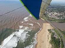
Umkomaas — surf near Mkomazi River mouth | |
 Umkomaas  Umkomaas  Umkomaas
| |
|
Location within Durban  Umkomaas | |
| Coordinates: 30°12′04″S 30°47′38″E / 30.201°S 30.794°ECoordinates: 30°12′04″S 30°47′38″E / 30.201°S 30.794°E | |
| Country | South Africa |
| Province | KwaZulu-Natal |
| Municipality | eThekwini |
| Established | c. 1861 |
| Area[1] | |
| • Total | 6.14 km2 (2.37 sq mi) |
| Population (2011)[1] | |
| • Total | 2,716 |
| • Density | 440/km2 (1,100/sq mi) |
| Racial makeup (2011)[1] | |
| • Black African | 19.3% |
| • Coloured | 1.9% |
| • Indian/Asian | 14.0% |
| • White | 64.2% |
| • Other | 0.6% |
| First languages (2011)[1] | |
| • English | 61.5% |
| • Afrikaans | 22.6% |
| • Zulu | 11.9% |
| • Other | 4.0% |
| Postal code (street) | 4170 |
| PO box | 4170 |
| Area code | 039 |

Umkomaas, a small coastal town on the subtropical south coast of KwaZulu-Natal, South Africa was formed when a harbour was built in 1861 to export sugar. The town rests beside the mouth of the navigable uMkhomazi River, also known as the Mkhomazi or Umkomaas. With the successful dredging of Durban harbour's sandbar and arrival of the railway, like Port Shepstone, the harbour fell into disuse, but the town came to life.
A large number of whales once used the estuary as a nursery, giving birth in the shallows. The Zulus named the river after this spectacle (uMkhomazi means the place of cow whales). The settlement was originally known as South Barrow, with its suburb known today as Ilfracombe then called North Barrow.
The town is located 48 km south of central Durban and is accessible by rail and by roads including the N2 Freeway and the coastal R102 or "Old Main Road."
The South African Navy mine countermeasures vessel SAS Umkomaas is named in honour of the river and town.

Industry
In 1954 an Italian consortium developed the large Saiccor industrial cellulose plant beside the river a short distance inland from the town. A large number of Italian immigrants and workers, mostly from the region of Friuli, followed suit, and the result is that Umkomaas probably had the largest Italian community relative to its total population of any town in Southern Africa.
Saiccor has for some time been a controversial plant. It was purchased by international pulp and paper giant Sappi in 1988, and while it continues to provide jobs for about 1200 workers, and a livelihood for their dependents, concerns were raised as early as the 1990s over Saiccor's adverse effect on asthmatic children at the nearby Umkomaas Drift School. In 1999 Saiccor paid for the relocation of the school.
Additionally, a large amount of effluent is pumped out to sea, and major extensions of this effluent pipe were carried out in 1987 and 1999, though Saiccor maintained for many years that the effluent was largely harmless. A well-known act was when Saiccor' chief executive drank a glass of effluent in front of the media to prove it was harmless.
Saiccor is today the world's largest producer of chemical cellulose, and employs about 1200 people directly and about 20 000 indirectly, its pulp being used largely for products such as viscose, acetate and cellophane.
The manufacture of over 1 billion components annually for the packaging industry and furniture assembly are also carried out in the area. Additional infrastructure includes the roads and railways built by and for Saiccor's operations, together with a stretch of Spoornet-owned coastal track, on which Saiccor to this day maintains and operates classic steam engines.
There are exotic eucalyptus and wattle plantations in the area, most of which were established for Saiccor. Farming in the area is mostly of cane sugar and sugar plantations are a prominent feature of the local landscape.
Umkomaas River
The Umkomaas or uMkomazi River is a dominant feature of the area, being the largest river on the South Coast. The river is 298 kilometres long, from its source just south of Giant's Castle in the uKhahlamba / Drakensberg Park World Heritage Site to its mouth on the Indian Ocean. The river begins its journey at an altitude of over 3,000 metres.
Occasionally, raft races, canoeing, and other sporting events are held on the river. The river is a popular white-water rafting destination. During the winter dry season, the river mouth often silts up, but after heavy rains it carries large amounts of brown sediment into the Indian Ocean. Some of this sedimentation is due to anthropogenic (human-made) pressures on the local ecosystem. These pressures include soil erosion caused by over-grazing, intensive cultivation, sewage disposal, informal farming and settlements, timber plantations, and the removal of sand or topsoil from the river's basin.[2]
The Umkomaas river valley is mentioned in an early chapter of Alan Paton's 1948 novel Cry, The Beloved Country. Probably derived from the Zulu word uMkhamazi, the name relates to the sighting of a whale in the river estuary at some point in history.[3] The river's tributaries include the Madoba, Mkhomazana, Mtungwane, Nhlatimbe and Nhlavini.
The river's basin covers about 4,315 km2, annual discharge is approximately 1 x 10⁶ m3 and sediment load is an estimated 900 000 tons per year.[4] Some parts of the river basin are vulnerable to flooding due to the steep topography and weather systems, such as intense thunderstorms and cut-off lows. This is exacerbated by land degradation and impervious urban areas. Some floods have resulted in loss of life, destruction of properties where development has encroached on floodplains in densely populated areas, and damage to roads and bridges.[5][6]
Tourism, Diving and Microlighting
Additional tourist attractions include the Umkomaas Golf Course, home of Tim Clark and widely regarded as being one of the best in KwaZulu-Natal, and the beautiful Empisini Nature Reserve, a forested area that features a delightful waterfall and a number of bush walks. The nearby settlement of Clansthal was the home of Conservationist Tony Pooley in the 1980s and 1990s. Swedish tennis player Mats Wilander was a regular visitor in the 1990s, and is rumoured to have been the owner of a large hotel on the corner of Moodie and Reynolds Street.
Umkomaas is most renowned for the superb diving opportunities created by the Aliwal Shoal, a volcanic reef about 5 kilometres offshore. Ragged-tooth sharks, rock cod, and a number of other species can be found in the shoal.
Growth in diving-related tourism has grown dramatically in the past decade, although the Shoal features two especially fine shipwrecks, the Nebo and the Produce, that long predate the Shoal's current surge in popularity. The Aliwal Shoal was formed about 80 000 years ago. Diving and accommodation information is available in the town and online.
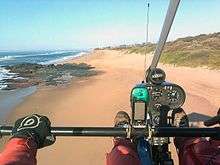
World of Wings Flight School, also known as WoW was recently established in Craigieburn by Noel McDonogh for antipoaching and to teach pilots to fly both weight shift microlights and Light Sport aircraft, in the recreational category. They offer services to Ezemvelo Kzn Wildlife for Antipoaching and monitor poaching along the beach fronts from Umkomaas to Pennington.
A further expansion will include PPL Flight Training, which allows flight in aircraft up to 5700 kg and this is the most cost-effective first step to an Aviation Career. You can do a PPL and build hours towards your Commercial license for about half the normal cost.
Why not enjoy an aerial view of the Umkomaas beachfront on your 'Intro flight'.
Schools and suburbs
A co-educational primary school, founded in 1913, is in the centre of the village.[7]
Suburbs of Umkomaas include Sunpark, Cragieburn and Widenham, known for its large bush-covered sand dune known as "Sand City", and the planned community of Saiccor Village, built for Saiccor workers in the 1950s and 1960s. Beaches are at Widenham and the Mkomazi River north bank near Ilfracombe, which is the launching point for many boat and diving trips to the Aliwal Shoal.
The population of Umkomaas in 2011 was 2,716, excluding Ilfracombe.[8] There are also townships which are part of the town(near) such as Roseneath, Clansthal, and Magabeni.
Wildlife
Umkomaas' official animal is the whale, representations of which can be found throughout the town, in everything from colourful murals to the primary school's uniform. Humpback whales are seen near Aliwal Shoal between June and October. Ragged-tooth and Zambezi sharks have been seen at the river mouth, in the wake of the September 1987 storms and 1984's Cyclone Domoina.
Other wildlife in the area includes snakes, most of them non-venomous species including the red-lipped herald and the brown house snake. Monkeys here are less common than in Scottburgh, but birds are abundant, including the hadeda ibis. Small wild cats like the genet and civet have been reported on rare occasions. Nile crocodiles found near Freeland Park and the lower Amahlongwa, 8 kilometres south, are not present in Umkomaas. Duiker abound and can be seen in Empisini. The larger bushbuck has also been seen in local bush.
A major spectacle occurring most years is the Sardine Run, the annual courtship migration (contingent on climatic conditions) of sardines from South Africa's southern coast to the warmer waters of KwaZulu-Natal. It usually occurs in July and has featured on Jeff Corwin's show on Animal Planet. The sardine attract many predatory fish, seabirds, and sharks, on a scale rarely seen anywhere else.
Umkomaas was one of the coastal towns affected by the high winds and freak waves generated by the storms of late March 2007. Beachfront areas and complex formerly known as 'The Whaler' were some parts of the town damaged in the storm.
World War II plane crash
A notable event in the town's history was the fatal air crash involving a Kitty Hawk Air Force plane during the Second World War. The aeroplane is believed to have sunk into quicksand on the south bank of the river between the village and the present-day location of Saiccor. A local group made numerous attempts to recover the wreckage of the craft in the 1980s, but as the precise location of the plane is still not decisively known, it has never been recovered. Subsequently much speculation exists as to where exactly the plane is buried.
Cragieburn


Newly formed in Craigieburn, World of Wings Flight School is a Flight Training School in the recreational, NPL (National Pilot Licensing) category which includes LSA; CCM and WCM (Light Sport Aircraft; Conventional Controlled Microlight and weight Shift Microlight). Aircraft that can carry two people. In due course it will be expanded to create a recommended syllabus, for Quad-Copter and drone operator training, the new Part 101 (which is presently non-existent), to the Authority, RAASA, (Recreational Aviation Association of South Africa), A further expansion will include PPL Flight Training, which allows flight in aircraft up to 5700 kg and is the first required step in an Aviation Career. The flying school will offer light sport, microlight and PPL flight training in a fun, yet professional atmosphere. Contact Noel McDonogh on: 0721175130
References
- 1 2 3 4 "Main Place Umkomaas". Census 2011.
- ↑ http://www.ewisa.co.za/misc/RiverKZNMkomazi/MKOMAZIRiver_Geology%20.htm
- ↑ http://www.ewisa.co.za/misc/RiverKZNMkomazi/MKOMAZIRiver_Overview%20.htm
- ↑ http://sajg.geoscienceworld.org/cgi/content/full/107/4/489
- ↑ http://www.ewisa.co.za/misc/RiverKZNMkomazi/MKOMAZIRiver_Hydrology%20.htm
- ↑ Department of Water Affairs and Forestry, South Africa. 2004. Internal Strategic Perspective: Mvoti to Mzimkulu Water Management Area : Prepared by Tlou and Matji (Pty) Ltd, WRP (Pty) Ltd, and DMM cc on behalf of the Directorate: National Water Resource Planning (East). DWAF Report No. P WMA 11/000/00/0304.
- ↑ http://umkomaasprimary.co.za/
- ↑ http://www.citypopulation.de/php/southafrica-kwazulunatal.php?cityid=599196001
Communities of eThekwini Metropolitan Municipality, KwaZulu-Natal | |||||||||||||||
|---|---|---|---|---|---|---|---|---|---|---|---|---|---|---|---|
Seat: Durban | |||||||||||||||
| Cities and towns |
| .svg.png) | |||||||||||||
| Suburbs of Durban |
| ||||||||||||||