Umatilla Bridge
| Umatilla Bridge | |
|---|---|
|
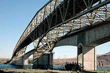
Looking north from Oregon; older bridge in the foreground | |
| Coordinates | 45°55′52″N 119°19′41″W / 45.931°N 119.328°WCoordinates: 45°55′52″N 119°19′41″W / 45.931°N 119.328°W |
| Carries |
|
| Crosses | Columbia River |
| Locale | Benton County, Washington – Umatilla County, Oregon |
| Official name |
Interstate 82 Columbia River Bridge |
| Characteristics | |
| Design |
Through truss cantilever bridge (old) Arch bridge (new) |
| Material |
Steel (old) Concrete (new) |
| Total length |
3,308 ft (1,008.3 m) (old) 3,433 ft (1,046.4 m) (new) |
| Width | 27.58 ft (8.4 m) (old) |
| Longest span | 600 ft (182.9 m) (old) |
| Number of spans |
5 (old) 2 (new) |
| Clearance above | 16 ft (4.9 m) (old) |
| Clearance below |
85 ft (25.9 m) (old) 80 ft (24.4 m) (new) |
| History | |
| Opened |
1955 (old), 61 years ago 1988 (new), 28 years ago |
| Statistics | |
| Daily traffic | 8,150 (2004) |
The Umatilla Bridge is the collective name for a pair of bridges in the northwest United States, carrying Interstate 82/U.S. Route 395 across the Columbia River at the Washington/Oregon border. The older bridge opened 61 years ago in 1955 and is a steel through truss cantilever bridge and carries southbound (east on I-82) traffic. Northbound traffic (west on I-82) travels on the newer concrete arch bridge, opened 28 years ago in 1988.
Construction
The old bridge was proposed by Umatilla County judge James H. Sturgis and known as "Sturgis' folly" initially. The construction upstream of McNary Dam would create Lake Wallula and submerge the old Wallula Highway. In the interim, traffic was carried across the newly formed lake via ferry service, with 178,576 vehicles transported in 1951.[1] The bridge was financed by $10 million worth of bonds and operated as a toll bridge[2] for 19 years until August 30, 1974,[3] when the bonds were fully repaid.[4]
It is a five-span continuous Warren through truss design. The configuration of the span is unusual in the fact that it takes advantage of a submerged island near the middle of the Columbia River. With its two 600-foot (180 m) spans, each constructed using the cantilever method, this is the only bridge in the state having two spans constructed using that method.[5]
References
- ↑ "Report on A Proposed Highway Bridge Across the Columbia River At Umatilla, Oregon". Umatilla County, Oregon, Benton County, Washington, Oregon Highway Commission, Washington Toll Bridge Authority. September 1952. Retrieved 2008-06-24.
- ↑ "Use of Umatilla Bridge suggested by Governor". Eugene Register-Guard. Oregon. Associated Press. February 4, 1958. p. 5B.
- ↑ "Tolls discontinued". Eugene Register-Guard. Oregon. Associated Press. August 31, 1974. p. 4A.
- ↑ Long, Priscilla; Gibson, Elizabeth (February 15, 2007). "Umatilla Bridge spanning the Columbia River opens on April 15, 1955". HistoryLink. Retrieved 2008-06-24.
- ↑ "Final List of Nationally and Exceptionally Significant Features of the Federal Interstate Highway System". Federal Highway Administration. Retrieved 2008-06-24.