Uluru
| Uluru (Uluṟu) | |
| Ayers Rock | |
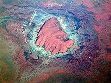
-crop.jpg) Aerial view of Uluru | |
| Country | Australia |
|---|---|
| State | Northern Territory |
| Elevation | 863 m (2,831 ft) |
| Prominence | 348 m (1,142 ft) |
| Coordinates | 25°20′42″S 131°02′10″E / 25.34500°S 131.03611°ECoordinates: 25°20′42″S 131°02′10″E / 25.34500°S 131.03611°E |
| Geology | arkose |
| Orogeny | Petermann |
| UNESCO World Heritage Site | |
| Name | Uluṟu–Kata Tjuṯa National Park |
| Year | 1987 (#11) |
| Number | 447 |
| Criteria | v,vi,vii,ix |
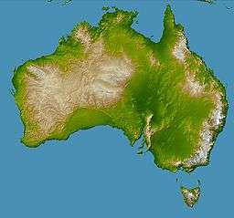  Location in Australia
| |
| Wikimedia Commons: Uluru | |
| Website: www.environment.gov.au/ | |
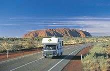
Uluru /ˌuːləˈruː/ (Pitjantjatjara: Uluṟu), also known as Ayers Rock /ˌɛərz ˈrɒk/ and officially gazetted as "Uluru / Ayers Rock",[1] is a large sandstone rock formation in the southern part of the Northern Territory in central Australia. It lies 335 km (208 mi) south west of the nearest large town, Alice Springs, 450 km (280 mi) by road.
Kata Tjuta and Uluru are the two major features of the Uluṟu-Kata Tjuṯa National Park. Uluru is sacred to the Pitjantjatjara Anangu, the Aboriginal people of the area. The area around the formation is home to an abundance of springs, waterholes, rock caves and ancient paintings. Uluru is listed as a UNESCO World Heritage Site.
Name
The local Anangu, the Pitjantjatjara people, call the landmark Uluṟu (Aboriginal pronunciation: [uluɻu]). This word is a proper noun, with no further particular meaning in the Pitjantjatjara dialect, although it is used as a local family name by the senior Traditional Owners of Uluru.[2]
On 19 July 1873, the surveyor William Gosse sighted the landmark and named it Ayers Rock in honour of the then Chief Secretary of South Australia, Sir Henry Ayers.[3] Since then, both names have been used.
In 1993, a dual naming policy was adopted that allowed official names that consist of both the traditional Aboriginal name and the English name. On 15 December 1993, it was renamed "Ayers Rock / Uluru" and became the first official dual-named feature in the Northern Territory. The order of the dual names was officially reversed to "Uluru / Ayers Rock" on 6 November 2002 following a request from the Regional Tourism Association in Alice Springs.[4]
Description
Uluru is one of Australia's most recognisable natural landmarks. The sandstone formation stands 348 m (1,142 ft) high, rising 863 m (2,831 ft) above sea level with most of its bulk lying underground, and has a total circumference of 9.4 km (5.8 mi).[5] Both Uluru and the nearby Kata Tjuta formation have great cultural significance for the Aṉangu people, the traditional inhabitants of the area, who lead walking tours to inform visitors about the local flora and fauna, bush food and the Aboriginal dreamtime stories of the area.
Uluru is notable for appearing to change colour at different times of the day and year, most notably when it glows red at dawn and sunset.
Kata Tjuta, also called Mount Olga or the Olgas, lies 25 km (16 mi) west of Uluru. Special viewing areas with road access and parking have been constructed to give tourists the best views of both sites at dawn and dusk.

Geology

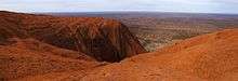
Uluru is an inselberg, literally "island mountain".[6][7][8] An inselberg is a prominent isolated residual knob or hill that rises abruptly from and is surrounded by extensive and relatively flat erosion lowlands in a hot, dry region.[9] Uluru is also often referred to as a monolith, although this is a somewhat ambiguous term that is generally avoided by geologists. The remarkable feature of Uluru is its homogeneity and lack of jointing and parting at bedding surfaces, leading to the lack of development of scree slopes and soil. These characteristics led to its survival, while the surrounding rocks were eroded.[10] For the purpose of mapping and describing the geological history of the area, geologists refer to the rock strata making up Uluru as the Mutitjulu Arkose, and it is one of many sedimentary formations filling the Amadeus Basin.[6]
Composition
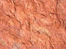
Uluru is dominantly composed of coarse-grained arkose (a type of sandstone characterized by an abundance of feldspar) and some conglomerate.[6][11] Average composition is 50% feldspar, 25–35% quartz and up to 25% rock fragments; most feldspar is K-feldspar with only minor plagioclase as subrounded grains and highly altered inclusions within K-feldspar.[6] The grains are typically 2–4 millimetres (0.079–0.157 in) in diameter, and are angular to subangular; the finer sandstone is well sorted, with sorting decreasing with increasing grain size.[6] The rock fragments include subrounded basalt, invariably replaced to various degrees by chlorite and epidote.[6] The minerals present suggest derivation from a predominantly granite source, similar to the Musgrave Block exposed to the south.[10] When relatively fresh, the rock has a grey colour, but weathering of iron-bearing minerals by the process of oxidation gives the outer surface layer of rock a red-brown rusty colour.[6] Features related to deposition of the sediment include cross-bedding and ripples, analysis of which indicated deposition from broad shallow high energy fluvial channels and sheet flooding, typical of alluvial fans.[6][10]
Age and origin

The Mutitjulu Arkose is believed to be of about the same age as the conglomerate at Kata Tjuta, and to have a similar origin despite the rock type being different, but it is younger than the rocks exposed to the east at Mount Conner,[6] and unrelated to them. The strata at Uluru are nearly vertical, dipping to the south west at 85°, and have an exposed thickness of at least 2,400 m (7,900 ft). The strata dip below the surrounding plain and no doubt extend well beyond Uluru in the subsurface, but the extent is not known.
The rock was originally sand, deposited as part of an extensive alluvial fan that extended out from the ancestors of the Musgrave, Mann and Petermann Ranges to the south and west, but separate from a nearby fan that deposited the sand, pebbles and cobbles that now make up Kata Tjuta.[6][10]
The similar mineral composition of the Mutitjulu Arkose and the granite ranges to the south is now explained. The ancestors of the ranges to the south were once much larger than the eroded remnants we see today. They were thrust up during a mountain building episode referred to as the Petermann Orogeny that took place in late Neoproterozoic to early Cambrian times (550–530 Ma), and thus the Mutitjulu Arkose is believed to have been deposited at about the same time.
The arkose sandstone which makes up the formation is composed of grains that show little sorting based on grain size, exhibit very little rounding and the feldspars in the rock are relatively fresh in appearance. This lack of sorting and grain rounding is typical of arkosic sandstones and is indicative of relatively rapid erosion from the granites of the growing mountains to the south. The layers of sand were nearly horizontal when deposited, but were tilted to their near vertical position during a later episode of mountain building, possibly the Alice Springs Orogeny of Palaeozoic age (400–300 Ma).[6]
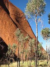
Fauna and flora
.jpg)
Historically, 46 species of native mammals are known to have been living near Uluru; according to recent surveys there are currently 21. Aṉangu acknowledge that a decrease in the number has implications for the condition and health of the landscape. Moves are supported for the reintroduction of locally extinct animals such as malleefowl, common brushtail possum, rufous hare-wallaby or mala, bilby, burrowing bettong, and the black-flanked rock-wallaby.[12]
The mulgara, the only mammal listed as vulnerable, is mostly restricted to the transitional sand plain area, a narrow band of country that stretches from the vicinity of Uluru to the northern boundary of the park and into Ayers Rock Resort. This area also contains the marsupial mole, woma python, and great desert skink.
The bat population of the park comprises at least seven species that depend on day roosting sites within caves and crevices of Uluru and Kata Tjuta. Most of the bats forage for aerial prey within 100 m (330 ft) or so from the rock face. The park has a very rich reptile fauna of high conservation significance, with 73 species having been reliably recorded. Four species of frogs are abundant at the base of Uluru and Kata Tjuta following summer rains. The great desert skink is listed as vulnerable.
Aṉangu continue to hunt and gather animal species in remote areas of the park and on Aṉangu land elsewhere. Hunting is largely confined to the red kangaroo, bush turkey, emu, and lizards such as the sand goanna and perentie.
Of the 27 mammal species found in the park, six are introduced: the house mouse, camel, fox, cat, dog, and rabbit. These species are distributed throughout the park, but their densities are greatest near the rich water run-off areas of Uluru and Kata Tjuta.
Uluṟu–Kata Tjuṯa National Park flora represents a large portion of plants found in Central Australia. A number of these species are considered rare and restricted in the park or the immediate region. Many rare and endemic plants are found in the park.
The growth and reproduction of plant communities rely on irregular rainfall. Some plants are able to survive fire and some are dependent on it to reproduce. Plants are an important part of Tjukurpa, and ceremonies are held for each of the major plant foods. Many plants are associated with ancestral beings.
Flora in Uluṟu–Kata Tjuṯa National Park can be broken into these categories:
- Punu – trees
- Puti – shrubs
- Tjulpun-tjulpunpa – flowers
- Ukiri – grasses
Trees such as the mulga and centralian bloodwood are used to make tools such as spearheads, boomerangs, and bowls. The red sap of the bloodwood is used as a disinfectant and an inhalant for coughs and colds.
Several rare and endangered species are found in the park. Most of them, like adder's tongue ferns, are restricted to the moist areas at the base of the formation, which are areas of high visitor use and subject to erosion.
Since the first Europeans arrived, 34 exotic plant species have been recorded in the park, representing about 6.4% of the total park flora. Some, such as perennial buffel grass (Cenchrus ciliaris), were introduced to rehabilitate areas damaged by erosion. It is the most threatening weed in the park and has spread to invade water- and nutrient-rich drainage lines. A few others, such as burrgrass, were brought in accidentally, carried on cars and people.
Climate and five seasons
The park has a hot desert climate and receives an average rainfall of 284.6 mm (11.2 in) per year.[13] The average high temperature in summer (December–January) is 37.8 °C (100.0 °F), and the average low temperature in winter (June–July) is 4.7 °C (40.5 °F). Temperature extremes in the park have been recorded at 46 °C (115 °F) during the summer and −5 °C (23 °F) during winter. UV levels are extreme between October and March, averaging between 11 and 15 on the UV index.[14][15]
Local Aboriginal people recognise five seasons:[5]
- Wanitjunkupai (April/May) – Cooler weather
- Wari (June/July) – Cold season bringing morning frosts
- Piriyakutu (August/September/October) – Animals breed and food plants flower
- Mai Wiyaringkupai (November/December) – The hot season when food becomes scarce
- Itjanu (January/February/March) – Sporadic storms can roll in suddenly
| Climate data for Yulara Aero | |||||||||||||
|---|---|---|---|---|---|---|---|---|---|---|---|---|---|
| Month | Jan | Feb | Mar | Apr | May | Jun | Jul | Aug | Sep | Oct | Nov | Dec | Year |
| Record high °C (°F) | 46.4 (115.5) |
45.8 (114.4) |
42.9 (109.2) |
39.6 (103.3) |
35.7 (96.3) |
36.4 (97.5) |
31.1 (88) |
35.0 (95) |
38.7 (101.7) |
42.3 (108.1) |
45.0 (113) |
47.0 (116.6) |
47.0 (116.6) |
| Average high °C (°F) | 38.4 (101.1) |
36.9 (98.4) |
34.4 (93.9) |
29.8 (85.6) |
24.2 (75.6) |
20.4 (68.7) |
20.4 (68.7) |
23.7 (74.7) |
28.8 (83.8) |
32.4 (90.3) |
35.1 (95.2) |
36.5 (97.7) |
30.1 (86.2) |
| Average low °C (°F) | 22.7 (72.9) |
22.1 (71.8) |
19.3 (66.7) |
14.4 (57.9) |
9.3 (48.7) |
5.6 (42.1) |
4.4 (39.9) |
5.9 (42.6) |
10.7 (51.3) |
15.0 (59) |
18.4 (65.1) |
20.8 (69.4) |
14.1 (57.4) |
| Record low °C (°F) | 12.7 (54.9) |
12.1 (53.8) |
8.0 (46.4) |
1.3 (34.3) |
1.1 (34) |
−1.8 (28.8) |
−3.6 (25.5) |
−2.2 (28) |
−1.0 (30.2) |
4.5 (40.1) |
6.5 (43.7) |
9.9 (49.8) |
−3.6 (25.5) |
| Average rainfall mm (inches) | 25.8 (1.016) |
39.6 (1.559) |
35.1 (1.382) |
14.7 (0.579) |
13.0 (0.512) |
17.4 (0.685) |
18.4 (0.724) |
4.3 (0.169) |
7.4 (0.291) |
20.7 (0.815) |
34.2 (1.346) |
40.2 (1.583) |
274.6 (10.811) |
| Average rainy days (≥ 1 mm) | 3.2 | 2.9 | 2.0 | 1.7 | 1.8 | 1.6 | 1.9 | 1.0 | 1.4 | 2.7 | 3.9 | 4.7 | 28.8 |
| Source: Bureau of Meteorology [13] | |||||||||||||
Aboriginal myths, legends and traditions
According to the Aṉangu, traditional landowners of Uluru:[16]
The world was once a featureless place. None of the places we know existed until creator beings, in the forms of people, plants and animals, traveled widely across the land. Then, in a process of creation and destruction, they formed the landscape as we know it today. Aṉangu land is still inhabited by the spirits of dozens of these ancestral creator beings which are referred to as Tjukuritja or Waparitja.
There are a number of differing accounts given, by outsiders, of Aboriginal ancestral stories for the origins of Uluru and its many cracks and fissures. One such account, taken from Robert Layton's (1989) Uluru: An Aboriginal history of Ayers Rock,[17] reads as follows:
Uluru was built up during the creation period by two boys who played in the mud after rain. When they had finished their game they travelled south to Wiputa ... Fighting together, the two boys made their way to the table topped Mount Conner, on top of which their bodies are preserved as boulders. (Page 5)
Two other accounts are given in Norbert Brockman's (1997) Encyclopedia of Sacred Places.[18] The first tells of serpent beings who waged many wars around Uluru, scarring the rock. The second tells of two tribes of ancestral spirits who were invited to a feast, but were distracted by the beautiful Sleepy Lizard Women and did not show up. In response, the angry hosts sang evil into a mud sculpture that came to life as the dingo. There followed a great battle, which ended in the deaths of the leaders of both tribes. The earth itself rose up in grief at the bloodshed, becoming Uluru.
The Commonwealth Department of Environment's webpage advises:[16]
Many...Tjukurpa such as Kalaya (Emu), Liru (poisonous snake), Lungkata (blue tongue lizard), Luunpa (kingfisher) and Tjintir-tjintirpa (willie wagtail) travel through Uluṟu-Kata Tjuṯa National Park. Other Tjukurpa affect only one specific area.
Kuniya, the woma python, lived in the rocks at Uluru where she fought the Liru, the poisonous snake.
It is sometimes reported that those who take rocks from the formation will be cursed and suffer misfortune. There have been many instances where people who removed such rocks attempted to mail them back to various agencies in an attempt to remove the perceived curse.[19][20]
History

Archaeological findings to the east and west indicate that humans settled in the area more than 10,000 years ago.[17] Europeans arrived in the Australian Western Desert in the 1870s. Uluru and Kata Tjuta were first mapped by Europeans in 1872 during the expeditionary period made possible by the construction of the Australian Overland Telegraph Line. In separate expeditions, Ernest Giles and William Gosse were the first European explorers to this area.
While exploring the area in 1872, Giles sighted Kata Tjuta from a location near Kings Canyon and called it Mount Olga, while the following year Gosse observed Uluru and named it Ayers Rock, in honour of the Chief Secretary of South Australia, Sir Henry Ayers. Further explorations followed with the aim of establishing the possibilities of the area for pastoralism. In the late 19th century, pastoralists attempted to establish themselves in areas adjoining the Southwestern/Petermann Reserve and interaction between Aṉangu and white people became more frequent and more violent. Due to the effects of grazing and drought, bush food stores became depleted. Competition for these resources created conflict between the two groups, resulting in more frequent police patrols. Later, during the depression in the 1930s, Aṉangu became involved in dingo scalping with 'doggers' who introduced Aṉangu to European foods and ways.
Between 1918 and 1921, large adjoining areas of South Australia, Western Australia, and the Northern Territory were declared as Aboriginal reserves, sanctuaries for nomadic people who had virtually no contact with European settlers. In 1920, part of Uluṟu–Kata Tjuṯa National Park was declared an Aboriginal Reserve (commonly known as the South-Western or Petermann Reserve) by the Australian government under the Aboriginals Ordinance.
The first tourists arrived in the Uluru area in 1936. Beginning in the 1940s, permanent European settlement of the area for reasons of the Aboriginal welfare policy and to help promote tourism of Uluru. This increased tourism prompted the formation of the first vehicular tracks in 1948 and tour bus services began early in the 1950s. In 1958, the area that would become the Uluṟu–Kata Tjuṯa National Park was excised from the Petermann Reserve; it was placed under the management of the Northern Territory Reserves Board and named the Ayers Rock–Mount Olga National Park. The first ranger was Bill Harney, a well-recognised central Australian figure.[12] By 1959, the first motel leases had been granted and Eddie Connellan had constructed an airstrip close to the northern side of Uluru.[3]
On 26 October 1985, the Australian government returned ownership of Uluru to the local Pitjantjatjara Aborigines, with one of the conditions being that the Aṉangu would lease it back to the National Parks and Wildlife agency for 99 years and that it would be jointly managed. An agreement originally made between the community and Prime Minister Bob Hawke that the climb to the top by tourists would be stopped was later broken. The Aboriginal community of Mutitjulu, with a population of approximately 300, is located near the eastern end of Uluru. From Uluru it is 17 km (11 mi) by road to the tourist town of Yulara, population 3,000, which is situated just outside the national park.
On 8 October 2009, the Talinguru Nyakuntjaku viewing area opened to public visitation. The A$21 million project about 3 kilometres (1.9 mi) on the east side of Uluru involved design and construction supervision by the Aṉangu traditional owners, with 11 kilometres (6.8 mi) of roads and 1.6 kilometres (1 mi) of walking trails being built for the area.[21][22]
Tourism
The development of tourism infrastructure adjacent to the base of Uluru that began in the 1950s soon produced adverse environmental impacts. It was decided in the early 1970s to remove all accommodation-related tourist facilities and re-establish them outside the park. In 1975, a reservation of 104 square kilometres (40 sq mi) of land beyond the park's northern boundary, 15 kilometres (9 mi) from Uluru, was approved for the development of a tourist facility and an associated airport, to be known as Yulara. The camp ground within the park was closed in 1983 and the motels closed in late 1984, coinciding with the opening of the Yulara resort. In 1992, the majority interest in the Yulara resort held by the Northern Territory Government was sold and the resort was renamed Ayers Rock Resort.
Since the park was listed as a World Heritage Site, annual visitor numbers rose to over 400,000 visitors by the year 2000.[23] Increased tourism provides regional and national economic benefits. It also presents an ongoing challenge to balance conservation of cultural values and visitor needs.
Admission
Admission to the park costs A$25 per person and provides a three-day pass. Passes are non-transferable and all passes are checked by park rangers.
Climbing
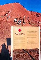
The local Aṉangu do not climb Uluru because of its great spiritual significance. They request that visitors do not climb the rock, partly due to the path crossing a sacred traditional Dreamtime track, and also due to a sense of responsibility for the safety of visitors. The visitors guide says "the climb is not prohibited, but we prefer that, as a guest on Aṉangu land, you will choose to respect our law and culture by not climbing."[5]
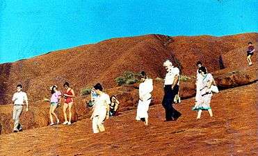
Despite being discouraged by its traditional owners, some visitors still climb Uluru. A chain handhold added in 1964 and extended in 1976 makes the hour-long climb easier, but it is still a steep, 800 m (0.5 mi) hike to the top, where it can be quite windy. It is recommended individuals drink plenty of water while climbing, and those who are unfit, suffer from vertigo or medical conditions restricting exercise, do not attempt it. Climbing Uluru is generally closed to the public when high winds are present at the top. There have been at least 35 deaths relating to recreational climbing since such incidents began being recorded.[5]
On 11 December 1983, the Prime Minister of Australia, Bob Hawke, promised to hand back the land title to the Aṉangu traditional custodians and caretakers and agreed to the community's 10-point plan which included forbidding the climbing of Uluru. The government, however, set access to climb Uluru and a 99-year lease, instead of the previously agreed upon 50-year lease, as conditions before the title was officially given back to the Aṉangu.[24]
The Aboriginal traditional owners of Uluṟu–Kata Tjuṯa National Park (Nguraritja) and the Federal Government's National Parks share decision-making on the management of Uluṟu–Kata Tjuṯa National Park. Under their joint Uluṟu–Kata Tjuṯa National Park Management Plan 2010-20, issued by the Director of National Parks under the Environment Protection and Biodiversity Conservation Act 1999, clause 6.3.3 provides that the Director and the Uluṟu–Kata Tjuṯa Board of Management work towards closure of the climb and, additionally, provides that it will close upon any of three conditions being met: there are "adequate new visitor experiences", less than 20 per cent of visitors make the climb or the "critical factors" in decisions to visit are "cultural and natural experiences".[25] Despite cogent evidence the second condition was met by July 2013, the climb remains open.[26]
Several controversial incidents on top of Uluru in 2010, including a striptease, golfing and nudity, led to renewed calls for banning the climb.[27][28]
 Prince Charles and Diana, The Princess of Wales returning from photo session on Uluru, March 1983
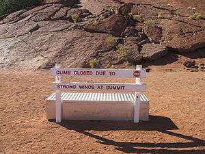 Sign informing tourists that the climb is closed due to strong winds
Photography
The Aṉangu also request that visitors do not photograph certain sections of Uluru, for reasons related to traditional Tjukurpa beliefs. These areas are the sites of gender-linked rituals and are forbidden ground for Aṉangu of the opposite sex to those participating in the rituals in question. The photographic restriction is intended to prevent Aṉangu from inadvertently violating this taboo by encountering photographs of the forbidden sites in the outside world.[29]
See also
- Mount Augustus National Park
- Indigenous Australian art
- Pitjantjatjara § Recognition of sacred sites
- Protected areas of the Northern Territory
References
- Notes
- ↑ "Place Names Register Extract: Uluru / Ayers Rock". Northern Territory Place Names Register. Northern Territory Government. 6 November 2002. Retrieved 12 July 2013.
- ↑ Issacs, Jennifer (1980). Australian Dreaming: 40,000 Years of Aboriginal History. Sydney: Lansdowne Press. pp. 40–41. ISBN 0-7018-1330-X. OCLC 6578832.
- 1 2 "Uluṟu–Kata Tjuṯa National Park – Early European history". Australian Department of the Environment and Water Resources. Retrieved 7 October 2008.
- ↑ "Dual Naming of Features". NT.gov.au. Retrieved 7 October 2008.
- 1 2 3 4 Welcome to Aboriginal land: Uluṟu–Kata Tjuṯa National Park – Visitor guide and maps (PDF). Canberra: Australian Department of the Environment and Water Resources. October 2005. OCLC 754614279. Retrieved 3 April 2007.
- 1 2 3 4 5 6 7 8 9 10 11 Young, David N.; Duncan, N.; Camacho, A.; Ferenczi, P.A.; Madigan, T.L.A. (2002). Ayers Rock, Northern Territory, Map Sheet GS52-8 (2nd edition) (Map). 1:250 000. Northern Territory Geological Survey. Geological Map Series Explanatory Notes.
- ↑ Twidale, C. R.; Campbell, Elizabeth M. (2005). Australian Landforms. Rosenberg. p. 141. ISBN 1-877058-32-7.
- ↑ Quinn, Joyce Ann; Woodward, Susan L., eds. (2015). Earth's Landscape: An Encyclopedia of the World's Geographic Features. ABC-CLIO. pp. 719–720. ISBN 978-1-61069-446-9.
- ↑ Neuendorf, Klaus K.E.; Mehl, Jr., James P.; Jackson, Julia A., eds. (2005). Glossary of Geology (5th ed.). Alexandria, VA: American Geological Institute. ISBN 0-922152-76-4.
- 1 2 3 4 Sweet, I.P.; Crick, I.H. (1992). Uluru & Kata Tjuta: A Geological History (Monograph). Canberra: Australian Geological Survey Organisation. ISBN 0-644-25681-8.
- ↑ "Uluṟu–Kata Tjuṯa National Park – Geology". Australian Department of the Environment and Water Resources. Retrieved 3 April 2007.
- 1 2 Uluṟu–Kata Tjuṯa Board of Management (2000). Uluṟu–Kata Tjuṯa National Park Plan of Management (PDF) (4th ed.). Canberra: Environment Australia. ISBN 0-642-54673-8. OCLC 57667136.
- 1 2 "Yulara Aero". Climate statistics for Australian locations. Bureau of Meteorology. Retrieved 14 May 2016.
- ↑ Yulara Ultraviolet (UV) Index Forecast Graph. Australian Bureau of Meteorology. Retrieved 20 April 2014.
- ↑ "Australian Climate Averages: Ultra violet index (Climatology 1979–2007)". Bureau of Meteorology, Australian Government. 21 March 2012. Retrieved 17 April 2014.
- 1 2 "The Creation Period". Department of the Environment, Water, Heritage and the Arts. Archived from the original on 17 January 2010.
- 1 2 Layton, Robert (August 2001). Uluru: An Aboriginal History of Ayers Rock (2001 revised ed.). Canberra: Aboriginal Studies Press. ISBN 0-85575-202-5.
- ↑ Brockman, Norbert C (June 1997). Encyclopedia of Sacred Places. Santa Barbara, California: ABC-Clio Inc. pp. 292–93. ISBN 0-19-512739-0.
- ↑ "Rock theft brings bad luck". The Age. 7 March 2003. Retrieved 3 April 2007.
- ↑ Marks, Kathy (12 May 2008). "Uluru tourists return 'cursed' souvenirs". New Zealand Herald. Retrieved 14 May 2008.
- ↑ Tlozek, Eric (8 October 2009). "'Spectacular' sunrise platform at Uluru". ABC News. Retrieved 8 October 2009.
- ↑ Hall, Lex (8 October 2009). "New Uluru view spares desert songlines". The Australian. Retrieved 8 October 2009.
- ↑ "World Heritage and International Significance". Department of the Environment, Water, Heritage and the Arts. Retrieved 17 May 2010.
- ↑ Toyne, Phillip; Vachon, Daniel (1984). Growing Up the Country: the Pitjantjatjara Struggle for Their Land. Fitzroy, Victoria: McPhee Gribble. p. 137. ISBN 0-14-007641-7. OCLC 12611425.
- ↑ Uluṟu–Kata Tjuṯa National Park – Management Plan 2010-2020. Canberra: Department of the Environment, Water, Heritage and the Arts. 2010. p. 102. ISBN 978-0-9807460-1-3.
- ↑ Laughland, Oliver (8 July 2013). "People still climbing Uluru despite closure condition being met". The Guardian. Retrieved 13 November 2015.
- ↑ "Rock rage rolls on". Northern Territory News. 30 June 2010. Retrieved 28 February 2011.
- ↑ Shears, Richard (28 June 2010). "Stripper sparks fury among Aboriginals after YouTube exotic dance on sacred Ayers Rock". Daily Mail. Retrieved 1 March 2011.
- ↑ "Uluṟu–Kata Tjuṯa National Park – Tjukurpa". Australian Department of the Environment and Water Resources. Archived from the original on 7 March 2007. Retrieved 3 April 2007.
- Bibliography
- Breeden, Stanley (1995). Growing Up at Uluru, Australia. Fortitude Valley, Queensland: Steve Parish Publishing. ISBN 0-947263-89-6. OCLC 34351662.
- Breeden, Stanley (2000) [1994]. Uluru: Looking After Uluru – Kata Tjuta, the Anangu Way. Roseville Chase, NSW: Simon & Schuster Australia. ISBN 0-7318-0359-0. OCLC 32470148.
- Hill, Barry (1 November 1994). The Rock: Travelling to Uluru. St Leonards, NSW: Allen & Unwin. ISBN 1-86373-778-2. OCLC 33146858.
- Mountford, Charles P. (1977) [1965]. Ayers Rock: Its People, Their Beliefs and Their Art. Adelaide: Rigby Publishing. ISBN 0-7270-0215-5. OCLC 6844898.
External links
| Wikimedia Commons has media related to Uluru. |
- Uluṟu–Kata Tjuṯa National Park – Australian Department of the Environment and Water Resources
- Northern Territory official tourism site