Ukwulu
| Ukwulu | |
|---|---|
| Town | |
|
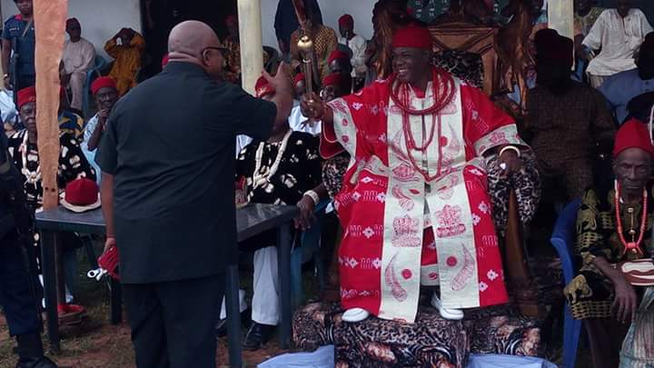
The Palace of the Monarch of Ukwulu | |
 Ukwulu | |
| Coordinates: NG 6°16′N 6°58′E / 6.267°N 6.967°E | |
| Country |
|
| State | Anambra State |
| LGA | Dunukofia |
| Government | |
| • Igwe T C Tagbo. Who was coronated in 1982 joined his ancestors in March 2015. He has since been buried March 10th 2016. | A new ruler was crowned on the 10th of June 2016. The new traditional ruler of Ukwulu town is now HRH Igwe Peter Anukwu Uyanwa. Ezeukwu of Ukwulu |
| Time zone | WAT (UTC+1) |

Ukwulu is a town in Dunukofia Local Government Area (LGA) of Anambra State, Nigeria. It is located 13.7 kilometres by road north of the LGA headquarters.[1] It is home to the Igbo peoples.[2] https://upload.wikimedia.org/wikipedia/commons/e/e6/HRH_2.jpg

History
The first officially documented leader of the town was Okafor Ozoife, who rose to power in the late 1800s as a warrant chief under the British occupation forces. He delineated the land mass of the town by locating beacons on the major boundaries of the town. He died in 1934 and the town was ruled by President Generals, who were elected by the people, up until 1977, when the current Igwe (King) was nominated, Dr. Timothy C. Tagbo, Eze Ukwu I of Ukwulu. [3]
Igwe T.C Tagbo passed on to glory in March 2015. He was committed to mother earth in the 10th of March 2016. The coronation of a new Igwe took place recently on the 10th of June 2016. The new traditional ruler of Ukwulu town is His Royal Highness Igwe Peter Anukwu Uyanwa. The Ezeukwu of Ukwulu land
In reality, most of Ukwulu’s history has little or no script systems or printed accounts; instead, each family handed down its history and laws by declaration.[4] Memories of great actions of renowned Kings, family histories, and significant events in the kingdom were passed down to generations preceding centuries by word of mouth.
Geography

The town is bordered by the towns of Achalla, Nando, Ukpo, Awkuzu and a number of others.[2] There are several rivers and streams in the town, some of which act as natural boundaries with neighbouring towns; some of which include, the Orira stream, Ndibe, Ali and Biobi rivers. Back in the days, Ukwulu had nine villages, a foreign war came upon the town and reduced it to what it is today. Until 3years ago, there were four villages namely Amagu, Umugama, Amaegbu, And Adagbe. Iruezeagu has since became an independent village there five villages in Ukwulu town The soils in the town are rich in nutrients and support the commercial farming of several local crops, which include yam, cassava, rice and other legumes.
Economy


The population is predominantly agrarian, but major in-roads have been made in commerce and education. The Electronics Development Institute of Nigeria (ELDI) is located in this town. Many roads in the area and the Anambra River Bridge were completed in the late 1980s.[5]
References
- ↑ Maps (Map). Google Maps.
- 1 2 Isichei, Elizabeth Allo (1 January 1977). Igbo worlds: an anthology of oral histories and historical descriptions. Macmillan. p. 323. ISBN 978-0-333-19837-7. Retrieved 28 April 2012.
- ↑ "Ukwulu". Dunukofiamustgrow.com. Retrieved 28 April 2012.
- ↑ Odionu, Osondu (2006). Local government evolution in Nigeria: The story of the Dunukofia Igbos. ABIC Books & Equip. Ltd. p. 249. ISBN 978022209X.
- ↑ West Africa. Afrimedia International. 1989. p. 433. Retrieved 28 April 2012.