Ugashik-Peulik
| Ugashik-Peulik | |
|---|---|
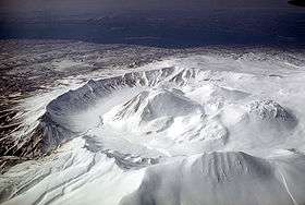 Aerial view, looking southwest, of Ugashik caldera adjacent to Peulik volcano. | |
| Highest point | |
| Elevation | 4,836 ft (1,474 m) |
| Coordinates | 57°45′04″N 156°22′05″W / 57.751°N 156.368°W |
| Geography | |
| Location | Lake and Peninsula Borough, Alaska, U.S. |
| Parent range | Aleutian Range |
| Topo map | USGS |
| Geology | |
| Mountain type | Stratovolcano |
| Volcanic arc/belt | Aleutian Arc |
| Last eruption | 1814 |
Ugashik-Peulik is a stratovolcano in the U.S. state of Alaska. It is located to the south of Becharof Lake in Lake and Peninsula Borough on the Alaska Peninsula. It is part of the Aleutian Range. Its last eruption was in 1814.
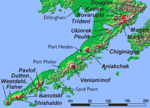
Map showing volcanoes of Alaska
Sources
- "Ugashik-Peulik". Global Volcanism Program. Smithsonian Institution.
- Volcanoes of the Alaska Peninsula and Aleutian Islands-Selected Photographs
- Alaska Volcano Observatory
This article is issued from Wikipedia - version of the 1/2/2016. The text is available under the Creative Commons Attribution/Share Alike but additional terms may apply for the media files.