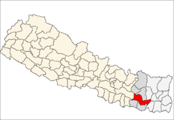
Udayapur District
| Udayapur उदयपुर | |
|---|---|
| District | |
 | |
| Country | Nepal |
| Region | Eastern Development Region (Purba Anchal) |
| Zone | Sagarmatha |
| Headquarters | gaighat |
| Area | |
| • Total | 2,063 km2 (797 sq mi) |
| Population (2011[1]) | |
| • Total | 317,532 (३१७५३२) |
| Time zone | NPT (UTC+5:45) |
Udayapur District (Nepali: उदयपुर जिल्ला![]() Listen , a part of Province No. 1, is one of the seventy-five districts of Nepal, a landlocked country of South Asia. The district, with Triyuga as its district headquarters, covers an area of 2,063 km² and in 2001 had a population of 287,689, in 2011 of 317,532.
Listen , a part of Province No. 1, is one of the seventy-five districts of Nepal, a landlocked country of South Asia. The district, with Triyuga as its district headquarters, covers an area of 2,063 km² and in 2001 had a population of 287,689, in 2011 of 317,532.
Geography and Climate
| Climate Zone[2] | Elevation Range | % of Area |
|---|---|---|
| Lower Tropical | below 300 meters (1,000 ft) | 33.7% |
| Upper Tropical | 300 to 1,000 meters 1,000 to 3,300 ft. |
45.9% |
| Subtropical | 1,000 to 2,000 meters 3,300 to 6,600 ft. |
17.8% |
| Temperate | 2,000 to 3,000 meters 6,400 to 9,800 ft. |
0.5% |
Village Development Committees (VDCs)and Municipalities in Udayapur
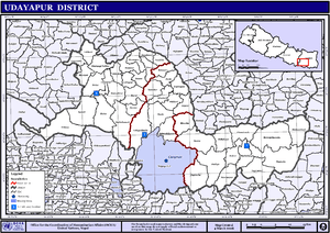
Map of the VDCs and Municipalities (blue) in Udayapur District
- Aaptar
- Balamta
- Baraha
- Barre
- Basabote
- Bhalayadanda
- Beltar Basaha Municipality
- Bhumarashuwa
- Bhuttar
- Chaudandi
- Dumre
- Hadiya
- Hardeni
- Iname
- Jalpachilaune
- Jante
- Jogidaha
- Katari Municipality
- Katunjebawala
- Khanbu
- Laphagaun
- Lekhani
- Lekhgaun
- Limpatar
- Mainamaini
- Mayankhu
- Nametar
- Okhale
- Panchawati
- Pokhari
- Rauta
- Risku
- Rupatar
- Saune
- Shorung Chabise
- Sirise
- Siddhipur
- Sundarpur
- Tamlichha
- Tapeshwari
- Tawasri
- Thanagaun
- Thoksila
- Triveni
- Triyuga Municipality
See also
References
- "Districts of Nepal". Statoids.
- ↑ General Bureau of Statistics, Kathmandu, Nepal, Nov. 2012
- ↑ The Map of Potential Vegetation of Nepal - a forestry/agroecological/biodiversity classification system (PDF), . Forest & Landscape Development and Environment Series 2-2005 and CFC-TIS Document Series No.110., 2005, ISBN 87-7903-210-9, retrieved Nov 22, 2013 horizontal tab character in
|series=at position 91 (help)
External links
| Wikimedia Commons has media related to Udayapur_District. |

Coordinates: 26°55′N 86°40′E / 26.917°N 86.667°E
This article is issued from Wikipedia - version of the 8/20/2016. The text is available under the Creative Commons Attribution/Share Alike but additional terms may apply for the media files.