Ubbergen
| Ubbergen | |||
|---|---|---|---|
| Town and former municipality | |||
|
Church in Beek | |||
| |||
.svg.png) Location in Gelderland | |||
| Coordinates: 51°50′N 5°55′E / 51.833°N 5.917°ECoordinates: 51°50′N 5°55′E / 51.833°N 5.917°E | |||
| Country | Netherlands | ||
| Province | Gelderland | ||
| Municipality | Berg en Dal | ||
| Area[1] | |||
| • Total | 38.88 km2 (15.01 sq mi) | ||
| • Land | 33.77 km2 (13.04 sq mi) | ||
| • Water | 5.11 km2 (1.97 sq mi) | ||
| Elevation[2] | 13 m (43 ft) | ||
| Population (May 2014)[3] | |||
| • Total | 9,404 | ||
| • Density | 278/km2 (720/sq mi) | ||
| Demonym(s) | Ubberger | ||
| Time zone | CET (UTC+1) | ||
| • Summer (DST) | CEST (UTC+2) | ||
| Postcode | 6570–6579 | ||
| Area code | 024 | ||
| Website |
www | ||


Ubbergen (![]() pronunciation ) is a former municipality and a town in the eastern Netherlands, in the municipality of Berg en Dal (formerly known as Groesbeek).
pronunciation ) is a former municipality and a town in the eastern Netherlands, in the municipality of Berg en Dal (formerly known as Groesbeek).
Gallery
 Ubbergen, monastery: complex de Refter
 Kekerdom, church
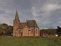 Persingen, church
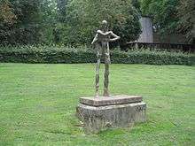 Statue of Nescio
References
- ↑ "Kerncijfers wijken en buurten" [Key figures for neighbourhoods]. CBS Statline (in Dutch). CBS. 2 July 2013. Retrieved 12 March 2014.
- ↑ "Postcodetool for 6573CL". Actueel Hoogtebestand Nederland (in Dutch). Het Waterschapshuis. Retrieved 18 July 2014.
- ↑ "Bevolkingsontwikkeling; regio per maand" [Population growth; regions per month]. CBS Statline (in Dutch). CBS. 26 June 2014. Retrieved 24 July 2014.
External links
 Media related to Ubbergen at Wikimedia Commons
- Official website
This article is issued from Wikipedia - version of the 1/11/2016. The text is available under the Creative Commons Attribution/Share Alike but additional terms may apply for the media files.