Ubatuba
| Município da Estância Balneária de Ubatuba Ubatuba | |||
|---|---|---|---|
| municipality | |||
|
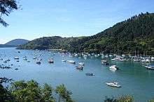
Ubatuba and the view of Mirante do Saco da Ribeira | |||
| |||
| Nickname(s): Capital do Surf (Surf capital) | |||
| Motto: Servavit Patria | |||
 Location in the state of São Paulo and Brazil | |||
| Coordinates: 23°26′22″S 45°4′12″W / 23.43944°S 45.07000°WCoordinates: 23°26′22″S 45°4′12″W / 23.43944°S 45.07000°W | |||
| Country | Brazil | ||
| Region | Southeast | ||
| State | São Paulo | ||
| Metropolitan Region | Vale do Paraíba e Litoral Norte | ||
| Settled | October 28, 1637 | ||
| Government | |||
| • Mayor | Maurício Moromizato (PT) | ||
| Area | |||
| • Total | 723.88 km2 (279.49 sq mi) | ||
| Elevation | 3 m (10 ft) | ||
| Population (2015)[1] | |||
| • Total | 86,392 | ||
| • Density | 114.1/km2 (296/sq mi) | ||
| Time zone | BRT (UTC-3) | ||
| • Summer (DST) | BRST (UTC-2) | ||
| Postal code | 11680-000 | ||
| Area code(s) | +55 12 | ||
| Website | City Hall website | ||


Ubatuba is a Brazilian municipality, located on the southeast coast, in the state of São Paulo. It is part of the Metropolitan Region of Vale do Paraíba e Litoral Norte.[2] The population is 86,392 (2015 est.) in an area of 723.88 km².[1]
Location
Ubatuba is linked with the Rodovia Longitudinal or the BR-101. It is located east of São Paulo and east/north/east of Santos and west of Rio de Janeiro. The city lies on the Tropic of Capricorn.
The urban area is mainly concentrated in the Atlantic and valley areas. The city frequently receives rain, hence the nickname Uba Chuva (chuva being Portuguese for "rain"). Much of the land to the north is forested and mountainous, forming a part of the Serra do Mar mountains. Serra do Mar State Park covers 83% of the city and has few connector roads through the mountain range.
The municipality contains part of the Tupinambás Ecological Station, which protects some of the coastal islands.[3] A marine park was created under Projeto TAMAR (TAMAR Project) to protect sea turtles. In addition, the Oceanographic Institute of the University of São Paulo runs the Clarimundo de Jesus research base in Ubatuba.
Tourism
Ubatuba is an important tourist city, receiving tourists from many parts of Brazil. Ubatuba features over 100 beaches. Among these are Maranduba, Lázaro, Itamambuca, Vermelha, Grande, Enseada, Perequê, and Saco da Ribeira. Ubatuba also features an island named Anchieta after José de Anchieta. It has been a nature preserve since March 22, 1977.
Ubatuba is considered, by law, as "The Surf Capital of São Paulo State". The city has received this honour because more than ten important surf contests are held off its beaches every year, including two world qualifying series, two Super Surf Pro series, and other competitions supported by such well-established brands as Billabong, Quiksilver and Dunkelvolk (which sponsored the 2009 edition of Ubatuba Surf Contest with more than 120 athletes).
Lately, the city is also known by its biodiversity, especially in relation to birds. There are more than 565 different birds species already identified (as of April 2012), what has each day attracted more and more birdwatchers.
History

The origin of the name comes from the Tupi words uyba (arrows or canoes) and tuba (many). Ubatuba was the place where the Portuguese signed the first treaty of peace of the Americas with the Tupinambá Indians (The Treaty of Peace of Yperoig - Tratado de Paz de Iperoig), a treaty that kept Brazil in Portuguese hands, with only one language and one faith (Catholicism). Back in the 16th century the Tupinambá families were forced into slavery, working on sugar cane plantations along the Southern Shores surrounding the towns of Saint Vincent and Itanhaém, a region also called "Morpion" at that time (according to André Thévet - "Singularités de la France Antarctique").
The Tupinambá responded to this outrage with the Tamoio Confederation, a powerful military alliance that stood to destroy Saint Vincent, with the help of the French, who had founded a Protestant refugee colony, France Antarctique in Guanabara Bay before the foundation of Rio de Janeiro. The Portuguese sent two Jesuit priests, Fathers Anchieta and Nobrega, to Ubatuba (a tribe named Yperoig), to make peace with the Tupinambá Indians. Anchieta was kept as a hostage and Nobrega returned to Saint Vincent along with the Chief Cunhambebe to make arrangements for the final Treaty. The Portuguese won, destroying France Antarctique and keeping the land.
Population history in numbers
| Year | Population |
|---|---|
| 2003 | 72,857 |
| 2004 | 76,847 |
| 2010 | 78,801 |
| 2015 | 86,392 |
Climate
| Climate data for Ubatuba, Brazil | |||||||||||||
|---|---|---|---|---|---|---|---|---|---|---|---|---|---|
| Month | Jan | Feb | Mar | Apr | May | Jun | Jul | Aug | Sep | Oct | Nov | Dec | Year |
| Average high °C (°F) | 30 (86) |
30 (86) |
29 (84) |
28 (82) |
26 (79) |
25 (77) |
24 (75) |
25 (77) |
25 (77) |
25 (77) |
26 (79) |
28 (82) |
26.8 (80.2) |
| Daily mean °C (°F) | 25 (77) |
25 (77) |
24 (75) |
22 (72) |
20 (68) |
18 (64) |
18 (64) |
19 (66) |
20 (68) |
21 (70) |
22 (72) |
24 (75) |
21.5 (70.7) |
| Average low °C (°F) | 21 (70) |
21 (70) |
20 (68) |
18 (64) |
15 (59) |
14 (57) |
13 (55) |
14 (57) |
16 (61) |
17 (63) |
18 (64) |
20 (68) |
17.3 (63.1) |
| Average rainfall mm (inches) | 366 (14.41) |
302 (11.89) |
315 (12.4) |
244 (9.61) |
125 (4.92) |
84 (3.31) |
106 (4.17) |
91 (3.58) |
170 (6.69) |
222 (8.74) |
259 (10.2) |
361 (14.21) |
2,645 (104.13) |
| Mean monthly sunshine hours | 105 | 106 | 106 | 102 | 109 | 106 | 110 | 104 | 78 | 73 | 83 | 92 | 1,174 |
| Source: The Weather Network [4] | |||||||||||||
See also
References
- 1 2 Instituto Brasileiro de Geografia e Estatística
- ↑ Assembleia Legislativa do Estado de São Paulo, Lei Complementar Nº 1.166
- ↑ Unidade de Conservação: Estação Ecológica Tupinambás (in Portuguese), MMA: Ministério do Meio Ambiente, retrieved 2016-04-18
- ↑ "Climate Statistics for Ubatuba, Brazil". Retrieved May 10, 2012.
External links
-
 Media related to Ubatuba at Wikimedia Commons
 -
 Ubatuba travel guide from Wikivoyage
 - (Portuguese) City Hall website
- (Portuguese) Ubatuba on Explorevale
 |
Natividade da Serra and São Luís do Paraitinga | Cunha | Parati | |
| Caraguatatuba | |
Parati | ||
| ||||
| | ||||
| Caraguatatuba | Atlantic Ocean |