U.S. Route 64
| |
|---|---|
 | |
| Route information | |
| Length: | 2,326 mi[1] (3,743 km) |
| Existed: | 1926[1] – present |
| Major junctions | |
| West end: |
|
|
| |
| East end: |
|
| Location | |
| States: | Arizona, New Mexico, Oklahoma, Arkansas, Tennessee, North Carolina |
| Highway system | |

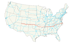
U.S. Route 64 (US 64) is an east–west United States highway that runs for 2,326 miles (3,743 km) from the Outer Banks in eastern North Carolina to just southwest of the Four Corners in northeast Arizona. The western terminus is at U.S. Route 160 in Teec Nos Pos, Arizona. The highway's eastern terminus is at NC 12 and U.S. Route 158 at Whalebone Junction, North Carolina.
Route description
Arizona
U.S. 64's western terminus is Teec Nos Pos, Arizona, at U.S. Route 160. It goes southeast from Teec Nos Pos and enters New Mexico.
New Mexico
U.S. 64 runs through Farmington, Taos, Angel Fire & Eagle Nest, Cimarron, and Raton. As it runs through Raton, it is co-signed with U.S. Route 87. It continues through to Clayton, where U.S. 87 is replaced by U.S. Routes 56 and 412. The three routes then run concurrently into Oklahoma. Twenty-eight miles north east of Cimarron is Raton Municipal Airport.
It is one of the roads on the Trails of the Ancients Byway, one of the designated New Mexico Scenic Byways.[2] At Angel Fire, U.S. 64 runs past the Vietnam Veterans Memorial State Park.
Texas
U.S. 64 does not technically cross into Texas. However, the Texas border does reach the shoulder of U.S. 64 outside of Clayton, NM, at 36°30′01″N 103°02′31″W / 36.500352°N 103.041922°W.
Oklahoma
Heading into the Oklahoma Panhandle, the three conjoined routes pick up a fourth two miles (3 km) southwest of Boise City, as U.S. 385 merges from the south. In Boise City, U.S. 385 departs to the north along with U.S. 287, which replaces U.S. 385 in the four-way concurrency on the way out of town to the east, before departing itself to the southeast two miles (3 km) outside of town. Shortly thereafter, U.S. 56 also departs the route, heading northeast into Kansas, while U.S. 64 and U.S. 412 continue their journey due east toward Guymon.
Near Guymon, the route turns due south to approach the town. U.S. 412 then heads due east, while U.S. 64 veers from due south to northeast, joining up with U.S. 54. These two routes remain together for about 20 miles (32 km), splitting at Hooker, with U.S. 54 continuing northeast into Kansas while U.S. 64 again veers due east. At Turpin, U.S. 64 turns left, running north with U.S. 83; three miles (5 km) later, it again turns east, joining U.S. 270 while U.S. 83 and westbound U.S. 270 continue north to Liberal, Kansas. Twenty miles to the east, U.S. 270 departs to the south, and U.S. 64 finally runs solo for a significant stretch save for very short concurrencies with U.S. 283 near Rosston, U.S. 183 through Buffalo, and U.S. 281 in Alva.
Near Pond Creek, U.S. 64 turns south, joined by U.S. 60 and U.S. 81. U.S. 64 splits off just north of Enid, jogging through the city before rejoining U.S. 412 on the east side of town. The two routes remain together until they meet Interstate 35, which U.S. 64 joins briefly southbound while U.S. 412 continues east, becoming the Cimarron Turnpike. U.S. 64 departs I-35 at Perry, intersecting the parallel U.S. 77 before continuing east.
On either side of Morrison the route intersects U.S. 177 and U.S. 412 (again) before passing through Pawnee and Cleveland. It then veers southeast, rejoining U.S. 412 yet again to head into Tulsa.
In downtown Tulsa, the route diverges from U.S. 412 for the final time. It shares pavement briefly (and separately) with Interstate 244 and U.S. 75 before bearing southeast through the city, intersecting Interstate 44 before briefly joining the southernmost five miles (8 km) of U.S. 169 running southbound on the eastern edge of the city. It then proceeds south, crossing the Creek Turnpike, then crosses the Arkansas River in Bixby before turning to the southeast.
After passing through Haskell, U.S. 64 and U.S. 62 meet head-on, north–south; they join and head east toward Muskogee. The routes disengage at the intersection with U.S. 69, with U.S. 64 bearing south out of the center of town. At Warner, the route turns eastward again, where it will run parallel to Interstate 40 for the remainder of its path through Oklahoma. It passes through Webbers Falls, Gore, Vian, Sallisaw (where it has a brief concurrence with U.S. 59), Muldrow, and Roland before leaving the state.
Arkansas

The route enters Arkansas in Fort Smith and crosses the Arkansas River. The route continues following Interstate 40 through Clarksville, Russellville, and Conway, where I-40 turns south an US 64 continues east. US 64 runs with US 67 and US 167 near Searcy before passing through rural Eastern Arkansas fields. US 64 runs east to Marion and West Memphis, where it meets I-40 and Interstate 55 to continue east over the Mississippi River on the Memphis & Arkansas Bridge to Memphis, Tennessee. A segment of US 64 in Crittenden County is also known as Military Road and is the oldest road in the state. It was surveyed for the removal of Native Tribes known of as the Trail of Tears. A historical marker in Marion notes this information.
Tennessee
US-64 enters Tennessee on the Memphis-Arkansas Bridge at Memphis. The route shares the bridge with Interstate 55 and U.S. Highways 61, 70, and 79. The route traverses several streets in Memphis before becoming a rural divided highway in eastern Shelby County. The highway runs directly to the east through the county seats of Tennessee's most southern counties. U.S. 64 then continues on past Lawrenceburg, the largest city on the State line between Memphis and Interstate 65, to Chattanooga. then U.S. 64 runs from Chattanooga to Cleveland, where it duplexes with US-74 to the North Carolina state line. The Tennessee Department of Transportation is currently working to expand the highway to four lanes across the state. The easternmost portion of the highway in Tennessee is the Ocoee Scenic Byway, a winding, two-lane road through the Ocoee River gorge in Polk County. The steep terrain around the highway is subject to landslides, such as the massive slide in November 2009 that closed the highway for several months.[3]
North Carolina
US 64 enters North Carolina in Cherokee County, west of Murphy. The highway serves the cities of Hendersonville, Brevard, Rutherfordton, Lenoir, Statesville, Lexington, Asheboro, Siler City, Cary, Raleigh, Rocky Mount, Tarboro, Williamston, and Manteo.
The segment from Franklin to Highlands is a mountainous two-lane road limited to moderate-sized trucks. Large trucks are routed via Truck US 64 (US 23/441 and US 74) to Sylva, and Asheville.
Interstate 40 travels through Statesville on a route originally designed in 1950 as a bypass of US 64, intersecting with Interstate 77 at what was once intended to be a bypass of US 21.
Within the Raleigh city limits US 64 follows the southern section of the Beltline. In 2006 a major section known as the Knightdale Bypass opened to ease traffic. After it was completed, US 64 became a divided freeway between Cary and Williamston, and carried at least four lanes between Asheboro and Columbia.
US 64 serves as a gateway to the Outer Banks, ending at Nags Head where it meets U.S. Route 158 and NC 12.
Overall, US 64 runs 563 miles (906 km) from the Western edge of the state to the Outer Banks. It is the longest highway in North Carolina. In North Carolina, the common way to express coverage of the entire state is to say, "from Murphy to Manteo." US 64 runs through both.
History
| |
|---|---|
| Location: | Santa Fe–Raton, New Mexico |
| Existed: | 1926–1931 |
U.S. Route 485 (US 485) was commissioned in 1926, looping west of US 85 between Santa Fe and Raton, New Mexico. In 1931, it became an extension of US 64. In 1959, the Arizona Department of Transportation submitted a proposal to extend US 64 west from Santa Fe, New Mexico to US 89 near Tuba City, Arizona, which was rejected.[4] The portion south of Taos was removed in 1974, when US 64 was realigned and extended to Farmington, and became NM 68.
Major intersections
- Arizona
-
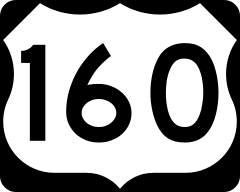 US 160 in Teec Nos Pos
 - New Mexico
-
 US 491 in Shiprock. The highways travel concurrently through Shiprock.
 -
 US 550 in Bloomfield. The highways travel concurrently through Bloomfield.
 -
 US 84 east of Monero. The highways travel concurrently to south-southwest of Tierra Amarilla.
 -
 US 285 in Tres Piedras
 -
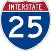
 I‑25 / US 85 south of Raton. The highways travel concurrently to Raton.
 -
 I‑25 / US 85 / US 87 in Raton. US 64/US 87 travels concurrently to Clayton.
 -
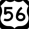
 US 56 / US 87 / US 412 in Clayton. US 56/US 64 travels concurrently to east-northeast of Boise City, Oklahoma. US 64/US 412 travels concurrently to Guymon.
 - Oklahoma
-
 US 385 southwest of Boise City. The highways travel concurrently to Boise City.
 -
 US 287 east of Boise City
 -
 US 54 in Guymon. The highways travel concurrently to Hooker.
 -
 US 83 in Turpin. The highways travel concurrently to north of Turpin.
 -
 US 83 / US 270 north of Turpin. US 64/US 270 travel concurrently to Forgan.
 -
 US 283 northwest of Rosston. The highways travel concurrently to east of Rosston.
 -
 US 183 in Buffalo. The highways travel concurrently to north-northeast of Buffalo.
 -
 US 281 in Alva. The highways travel concurrently through the city.
 -

 US 60 / US 81 west of Pond Creek. The highways travel concurrently to the Enid–North Enid city line.
 - US 412 in Enid. The highways travel concurrently to north-northwest of Perry.
-
 I‑35 / US 412 north-northwest of Perry. I-35/US 64 travels concurrently to Perry.
 -
 US 77 in Perry. The highways travel concurrently through Perry.
 -
 US 177 west-southwest of Morrison
 - US 412 east of Morrison
- US 412 in Westport. The highways travel concurrently to Tulsa.
-

 I‑244 / US 75 in Tulsa. The highways travel concurrently through Tulsa.
 -
 I‑244 / I‑444 / US 75 / US 412 in Tulsa. I-444 and US 64 have a hidden concurrency through Tulsa.
 -
 I‑44 in Tulsa
 -
 US 169 in Tulsa. The highways travel concurrently through Tulsa.
 -
 US 62 north-northeast of Boynton. The highways travel concurrently to Muskogee.
 -
 US 62 / US 69 in Muskogee. The highways travel concurrently through Muskogee.
 -
 US 266 in Warner
 -
 US 59 in Sallisaw. The highways travel concurrently through Sallisaw.
 -
 I‑40 in Sallisaw
 - I‑40 south-southwest of Roland
- Arkansas
-

 I‑540 / US 71 in Van Buren
 - I‑40 in Clarksville
- I‑40 in Lamar
- I‑40 in London
-
 I‑40 / US 65 in Conway
 -

 US 67 / US 167 in Beebe. The highways travel concurrently to Bald Knob.
 -
 US 49 in Fair Oaks
 -


 I‑55 / US 61 / US 63 in Marion. I-55/US 61/US 64 travels concurrently to Memphis, Tennessee. US 63/US 64 travels concurrently to West Memphis.
 -
 I‑40 / US 63 / US 79 in West Memphis. I-40/US 64 travels concurrently through West Memphis. US 64/US 79 travels concurrently to the Memphis–Bartlett, Tennessee city line.
 -
 US 70 in West Memphis. The highways travel concurrently to the Memphis–Bartlett, Tennessee city line.
 - Tennessee
-
 US 78 in Memphis
 -
 US 51 in Memphis. The highways travel concurrently through Memphis.
 -
 I‑240 in Memphis
 -
 US 72 in Memphis
 - I‑40 in Memphis
- I‑40 on the Memphis–Bartlett city line
-
 I‑269 in Eads
 -
 US 45 in Selmer. The highways travel concurrently through Selmer.
 -
 US 43 in Lawrenceburg. The highways travel concurrently through Lawrenceburg.
 -
 US 31 in Pulaski
 -
 I‑65 west of Frankewing
 -

 US 231 / US 431 in Fayetteville. US 64/US 231 travels concurrently through Fayetteville.
 -
 I‑24 southwest of Pelham. The highways travel concurrently to Kimball.
 - I‑24 / US 72 in Kimball. US 64/US 72 travels concurrently to Chattanooga.
-
 US 41 in Jasper. The highways travel concurrently to Chattanooga.
 - I‑24 in Chattanooga
-
 US 11 in Chattanooga. The highways travel concurrently to Cleveland.
 -
 US 27 in Chattanooga
 - I‑24 in Chattanooga
-
 US 41 / US 76 in Chattanooga. The highways travel concurrently through Chattanooga.
 -
 I‑75 in Chattanooga. The highways travel concurrently to north of Collegedale.
 -
 US 74 in East Cleveland. The highways travel concurrently to Murphy, North Carolina.
 -
 US 411 in Ocoee
 - North Carolina
-

 US 19 / US 129 southwest of Murphy. The highways travel concurrently to Murphy.
 -

 US 23 / US 441 in Franklin. The highways travel concurrently to southeast of Franklin.
 -
 US 178 northwest of Rosman
 -
 US 276 in Brevard. The highways travel concurrently through Brevard.
 -

 I‑26 / US 25 / US 74 in Hendersonville
 -
 US 221 in Rutherfordton
 - I‑40 in Morganton
- US 70 in Morganton. The highways travel concurrently through Morganton.
-
 US 321 in Lenoir
 - I‑40 in Statesville
- US 70 in Statesville
-
 US 21 in Statesville. The highways travel concurrently through Statesville.
 - I‑40 in Statesville
- I‑40 east-northeast of Statesville
- I‑40 west-northwest of Mocksville
-
 US 601 in Mocksville. The highways travel concurrently through Mocksville.
 -
 US 158 / US 601 in Mocksville
 -
 US 52 in Lexington
 -
 US 29 / US 70 in Lexington. The highways travel concurrently through Lexington.
 -
 I‑85 east-southeast of Lexington
 -


 I‑73 / I‑74 / US 220 in Asheboro
 -
 US 421 in Siler City
 -

 US 15 / US 501 north of Pittsboro
 -
.svg.png) Future I‑540 in Apex
Future I‑540 in Apex -
 US 1 in Cary. The highways travel concurrently to Raleigh.
 -
 I‑40 / I‑440 / US 1 in Raleigh. I-40/US 64 travels concurrently through Raleigh.
 -
 US 70 / US 401 in Raleigh
 - I‑40 / I‑440 in Raleigh. I-440/US 64 travels concurrently through Raleigh.
-
 I‑440 / I‑495 / US 264 in Raleigh. I-495/US 64 travels concurrently to Knightdale. US 64/US 264 travels concurrently to Zebulon.
 -
.svg.png) I‑95 / Future I‑495 in Rocky Mount
I‑95 / Future I‑495 in Rocky Mount -
 US 301 in Rocky Mount
 -
 US 258 in Tarboro. The highways travel concurrently to Princeville.
 -
 US 13 north of Bethel. The highways travel concurrently to Williamston.
 -
 US 17 south of Williamston. The highways travel concurrently for approximately 1.7 miles (2.7 km).
 - US 264 southwest of Manns Harbor
- US 158 in Nags Head
Bannered routes
Alternate routes
- US 64A - Franklinville to Ramseur, North Carolina (former)
- US 64A - Brevard, North Carolina (former)
- US 64A - Bat Cave to Morganton, North Carolina (former)
- US 64A - Statesville, North Carolina (former)
- US 64A - Siler City, North Carolina (former)
- ALT US 64 - Spring Hope to Nashville, North Carolina
- US 64A - Rocky Mount, North Carolina (former)
- ALT US 64 - Rocky Mount to Tarboro, North Carolina
- ALT US 64 - Princeville to Williamston, North Carolina
- US 64A - Williamston, North Carolina (former)
- US 64A - Columbia, North Carolina (former)
Business routes
There are several sections of Business US 64 serving more as alternate routes of the main highway. While they go through towns and cities, they often run numerous miles through rural areas and often pass through more than one city.
- BUS US 64 - Farmington, New Mexico
- BUS US 64 - Enid, Oklahoma (former)
- BUS US 64 - Muskogee, Oklahoma
- US 64B - Alma, Arkansas
- US 64B - Vilonia, Arkansas
- US 64C - Beebe, Arkansas (former)
- US 64B - Augusta, Arkansas
- US 64B - Patterson to McCrory, Arkansas
- US 64B - Wynne, Arkansas
- US 64B - Parkin, Arkansas
- US 64B - Earle, Arkansas
- US 64B - Crawfordsville, Arkansas
- BUS US 64 - Whiteville, Tennessee
- BUS US 64 - Selmer, Tennessee
- BUS US 64 - Fayetteville, Tennessee
- BUS US 64 - Winchester, Tennessee
- BUS US 64 - Hayesville, North Carolina
- BUS US 64 (1960–1980) - Brevard, North Carolina (former)
- BUS US 64 (2006–present) - Brevard, North Carolina
- BUS US 64 - Morganton, North Carolina
- BUS US 64 - Statesville, North Carolina (former)
- BUS US 64 - Pittsboro, North Carolina
- BUS US 64 - Raleigh to Zebulon, North Carolina
- BUS US 64 - Nashville, North Carolina
- BUS US 64 - Rocky Mount, North Carolina
- BUS US 64 - Tarboro to Princeville, North Carolina (former)
- BUS US 64 - Williamston, North Carolina (former)
- BUS US 64 - Jamesville, North Carolina
- BUS US 64 - Columbia, North Carolina
Bypass routes
- APD-40 - Cleveland, Tennessee
- BYP US 64 - Morganton, North Carolina
- US 64 Byp. - Manns Harbor to Manteo, North Carolina
Spur routes
- US 64S - Wynne, Arkansas
Truck routes
Photo gallery
 U.S. Route 64 in Cimarron, New Mexico.
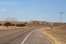 US-64 in Woods County, Oklahoma.
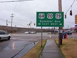 US64/US70/US79 overlap in Memphis, Tennessee (2008).
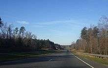 U.S. Route 64 near Siler City, North Carolina.
See also
Related routes
- U.S. Route 164 (former)
- U.S. Route 264
References
- 1 2 Droz, Robert V. U.S. Highways : From US 1 to (US 830). URL accessed 02:55, 4 July 2006 (UTC).
- ↑ Trail of the Ancients. New Mexico Tourism Department. Retrieved August 14, 2014.
- ↑ "Strike Two—Ocoee Gorge Rockslide Closes U. S. Highway 64". Retrieved 25 September 2014.
- ↑ "Arizona DOT Right-of-Way Resolutions". Azhighwaydata.com. 21 July 1959. Retrieved August 17, 2012.
External links
 Media related to U.S. Route 64 at Wikimedia Commons
| Browse numbered routes | ||||
|---|---|---|---|---|
| ← | OK | SH-65 | ||
Routes in italics are no longer a part of the system. Highlighted routes are considered main routes of the system. |