U.S. Route 460
| |
|---|---|
 | |
| Route information | |
| Auxiliary route of US 60 | |
| Length: | 655 mi (1,054 km) |
| Existed: | 1933 – present |
| Major junctions | |
| West end: |
|
|
| |
| East end: |
|
| Location | |
| States: | Kentucky, West Virginia, Virginia |
| Highway system | |

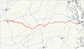
U.S. Route 460 is a spur of U.S. Route 60. It currently runs for 655 miles (1,054 km) from Norfolk, Virginia at U.S. Route 60 at Ocean View to Frankfort, Kentucky at U.S. Route 60. It passes through the states of Virginia, West Virginia, and Kentucky. It goes through the cities of Norfolk, Portsmouth, Suffolk, Petersburg, Farmville, Lynchburg, Roanoke, Blacksburg, Tazewell, and Grundy, in Virginia; Princeton and Bluefield in West Virginia; and Pikeville, Kentucky, Frankfort, Kentucky.
The section from Interstate 81 at Christiansburg, Virginia to U.S. Route 23 in Pikeville, Kentucky is Corridor Q in the Appalachian Development Highway System. Currently the portion improved under this system is unfinished between Grundy, Virginia and Pikeville.
US 460 is a major east–west highway in Virginia. It is a major thoroughfare through southern Hampton Roads and connects the area to Petersburg. US 460 connects Lynchburg to Roanoke. US 460 is paired with US 221 between Bedford and Roanoke and with US 11 between Salem and Christiansburg. It is also the primary east–west roadway in the northern part of Southwest Virginia between Christiansburg and the Kentucky border; although several miles near Bluefield pass through West Virginia.
Route description
Kentucky
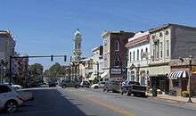
US 460 now begins when it splits from US 60 a few miles east of downtown Frankfort. It is a winding two-lane highway with no shoulders and intersects US 62 and I-75 at Georgetown. It proceeds to Paris, where it serves as the town's "Main Street" and intersects US 27 and US 68. The next major intersection is with I-64 in Mount Sterling. It proceeds through Frenchburg and West Liberty. In Salyersville, the Mountain Parkway ends by merging onto it. It is a 3-lane highway for 14 miles and then it merges with US 23 in Paintsville. US 460 East follows US-23 South through Prestonsburg and Pikeville. The route then enters the southwestern part of Virginia.
Virginia and West Virginia
.jpg)
U.S. Route 460 runs east–west through the southern part of the Virginia. It has two separate pieces in Virginia, joined by a relatively short section in West Virginia. Most of US 460 is a four-lane divided highway.
US 460 from Interstate 81 at Christiansburg west to Pikeville, Kentucky, including the piece in West Virginia, is Corridor Q of the Appalachian Development Highway System. From West Virginia east to I-81, US 460 is also part of the proposed Interstate 73.
History
Part of the track of the highway was once known as the Trader's Path, a Virginia colonial trail dating from the 17th century that led from Augusta County to present-day Roanoke.[1] Before it was commissioned as a federally designated route in the late 1940s, US 460 was Kentucky Route 40 from Lexington to Paintsville and Kentucky Route 4 from Millard to the Virginia state line near Grundy.[2]
US 460 once ended in St. Louis, Missouri after crossing the MacArthur Bridge. Between St. Louis and Frankfort, it was a major highway in the pre-Interstate era, passing through Evansville, Indiana and Louisville, Kentucky. Interstate 64 has supplanted most of old US 460 as a more direct route, and old US 460 has become parts of Illinois Route 15, Illinois Route 142, Illinois Route 14, State Road 66, State Road 62, and US 60 where Interstate 64 has not supplanted it even as a state highway in the greater Louisville area.
Many years after its elimination in Indiana in 1977, some older residents and even businesses along what is now Indiana State Road 62 still refer to the road as "Highway 460," to the point that older billboards retain that designation in the St. Meinrad area. Some present-day telephone books also contain listings for those living on "Hwy 460."
When Fishtrap Lake was created in Pike County, Kentucky, US 460 was realigned to its current route from Salyersville to Paintsville. The former US 460 leading to the lake is now Kentucky Route 1789 and Kentucky Route 1499. The part between Paintsville and Millard remained U.S. Highway 23 and Kentucky Route 80.[3]
Major intersections
- Kentucky
-

 US 60 / US 421 in Frankfort
 -
 US 25 in Georgetown
 -
 US 62 in Georgetown
 -
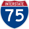 I‑75 in Georgetown
 -

 US 27 / US 68 in Paris
 -
 I‑64 in Mt. Sterling
 - US 60 in Mt. Sterling. The highways travel concurrently through Mt. Sterling.
-
 US 23 in Paintsville. The highways travel concurrently to Pikeville.
 -
 US 119 in Pikeville. The highways travel concurrently through Pikeville.
 - Virginia
-
 US 19 in Claypool Hill. The highways travel concurrently to Bluefield.
 - West Virginia
-
 US 52 in Bluefield. The highways travel concurrently through Bluefield.
 - US 19 northeast of Bluefield. The highways travel concurrently to southwest of Princeton.
-
 I‑77 east-southeast of Princeton
 - Virginia
-
 US 219 in Rich Creek
 -
 US 11 in Christiansburg
 -
 I‑81 in Christiansburg. The highways travel concurrently through Christiansburg.
 - I‑81 / US 11 in Christiansburg. US 11/US 460 travels concurrently to Salem.
-

 I‑581 / US 220 in Roanoke
 -
 US 11 / US 221 in Roanoke. US 221/US 460 travels concurrently to Bedford.
 -
 US 29 south of Lynchburg. The highways travel concurrently to Lynchburg.
 -
 US 501 in Lynchburg. The highways travel concurrently through Lynchburg.
 -
 US 15 west-northwest of Farmville. The highways travel concurrently to south of Farmville.
 -
 US 360 west of Burkeville. The highways travel concurrently to east of Burkeville.
 -
 I‑85 southwest of Petersburg. The highways travel concurrently to Petersburg.
 -
 US 1 southwest of Petersburg
 -
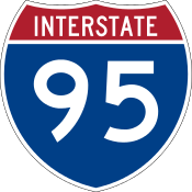 I‑85 / I‑95 in Petersburg. I-95/US 460 travels concurrently through Petersburg.
 -
 US 301 in Petersburg
 -
 I‑295 southeast of Petersburg
 -
 US 258 in Windsor
 -

 US 13 / US 58 in Suffolk. The highways travel concurrently to Chesapeake.
 -
 I‑664 in Chesapeake. The highways travel concurrently through Chesapeake.
 - I‑64 in Chesapeake
-
 US 17 in Chesapeake
 -
 I‑264 in Norfolk
 - US 58 in Norfolk. The highways travel concurrently through Norfolk.
-
 I‑564 in Norfolk
 - I‑64 in Norfolk
- I‑64 in Norfolk
- US 60 in Norfolk
See also
References
- ↑ Frazier Associates. 1992. "Historical Architecture Reconnaissance Survey Report. Roanoke, Virginia." April 1992. Page 2.
- ↑ Fun Facts About Kentucky Highways: US 460
- ↑ July 4 2006 Roadtrip
| Browse numbered routes | ||||
|---|---|---|---|---|
| ← | WV | I‑470 | ||