U.S. Route 231
| |
|---|---|
 | |
| Route information | |
| Auxiliary route of US 31 | |
| Length: | 912 mi (1,468 km) |
| Major junctions | |
| South end: |
|
|
| |
| North end: |
|
| Location | |
| States: | Florida, Alabama, Tennessee, Kentucky, Indiana |
| Highway system | |

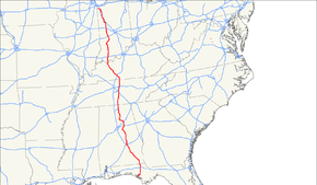
U.S. Route 231 is a parallel route of U.S. Route 31. It runs for 912 miles (1,467 km) from St. John, Indiana, at U.S. Route 41 to south of U.S. Route 98 in downtown Panama City, Florida.
One of its most notable landmarks is the William H. Natcher Bridge, a nearly mile-long cable-stayed bridge that connects Rockport, Indiana, to Owensboro, Kentucky, spanning the Ohio River.
Route description
Florida
In Florida, US 231 is paired with unsigned State Road 75. The southern terminus is at Business US 98 (unsigned State Road 30) in downtown Panama City. The highway is carried by Harrison Avenue until its intersection with US 98. Continuing north, US 231 passes through Youngstown, Fountain, Alford, Cottondale, and Campbellton before entering Alabama. Major intersections include Business US 98, US 98, SR 77, SR 20, Interstate 10, US 90, SR 73, SR 273, and SR 2.
Alabama
In Alabama, US 231 is paired with unsigned State Route 53 from Huntsville to Dothan. From the Tennessee state line to Huntsville, and from Dothan to the Florida state line, this route is paired with unsigned State Route 1. From the Tennessee line to Huntsville, US 231 pairs with US 431. In Harpersville US 231 follows US 280 east. Just south of Sylacauga US 231 branches off southward again as its own route, concurrent with signed SR 21, to Montgomery. From Montgomery to Pike Road, US 231 is concurrent with US 82, after which it and unsigned SR 53 continue southeastward to Dothan. US 231 is referred to as Memorial Parkway throughout Huntsville and Madison County.
In Dothan, there is a spur of US 231, Business US 231, which runs north–south directly through downtown Dothan from US 231 at the Ross Clark Circle. Until the 1980s, there were several other Business US 231 designations near and through the towns of Brundidge, Troy, and Montgomery.
Also, until the 1980s, there was an Alternate US-231 which ran north from the intersection/interchange with US-280 just south of Sylacauga, Alabama, northeastward through Sylacauga, Winterboro, and onto Talladega, Alabama. This routing was co-signed with Alabama State Route 21. From Talladega, Alternate US-231 ran northward co-signed with Alabama State Route 77 to just south of Lincoln, Alabama. There for a one-mile segment, Alternate US 231 ran along its own route just west of and parallel to Alabama State Route 77 until it reached an intersection with US-78 in the center of the small town of Lincoln, Alabama. There Alternate US-231 turned westward for nine miles co-signed with US-78 into Pell City, Alabama. There Alternate US-231 rejoined US-231. Alternate US-231 was decommissioned in the early 1980s.
Much of US 231 throughout north and central Alabama is a two-lane route. However, from just north of Wetumpka, Alabama, southward to the Florida state line the route is four lanes. Also, the section from the Tennessee-Alabama state line southward to Arab, AL, is also four lanes. In north and central Alabama, US 231 traverses the SW to NE ridgelines of the Appalachian Mountains as well as crossing several river valleys which provide some excellent natural scenery. Most of the four-lane segment south of Wetumpka, Alabama, to the Florida state line is along gently rolling countryside from several river and stream valleys onto the Gulf Coastal Plain.
Tennessee
US 231 enters Tennessee from Alabama in a concurrency with US 431 until it reaches Fayetteville. North of there it runs through Shelbyville and later passes through the eastern part of the Nashville metro area, passing through the cities of Murfreesboro, and Lebanon. By the time it reaches Bethpage, it joins U.S. Route 31E in another concurrency to the northeast before finally crossing the Kentucky State Line north of Westmoreland. The route is approximately 121 miles (195 km) from Tennessee's northern border to its southern border.
Kentucky
US 231 parallels Interstate 65 before reaching Bowling Green. From Bowling Green, US 231 closely parallels the William H. Natcher Parkway until it reaches Owensboro. At Owensboro, US 231 joins US 60 (also known as the Wendell H. Ford Expressway) around the city's east side, which it then follows to just north of Maceo. US 60 then leaves toward the east while US 231 turns to the north, leaving the state via the William H. Natcher Bridge across the Ohio River.
A portion of the Owensboro-area route is relatively new; in 2014, a new section from Kentucky 54 to Kentucky 2830 opened, bypassing the former bypass route. Part of that former route has been renumbered as Kentucky 603. The remainder, south of 603, is partly a dead-end city street and an abandoned lane that will eventually become part of the David Adkisson Greenbelt trail.
Indiana
In Indiana, US 231 has the distinction of being the state's longest continuous highway. It covers approximately 297 miles (478 km) in the Hoosier State. US 231 passes through the towns of Dale, Huntingburg, Jasper, and Loogootee before reaching Bloomfield. In Bloomfield, US 231 passes Shawnee Field, a local airport. US 231 slices through central Indiana before reaching Lafayette, where it runs just south of Purdue University. Next it winds northwest along Interstate 65 and then it splits off and terminates at US 41.
Indiana's Major Moves program, which derives its funding from the lease of the Indiana Toll Road to private interests, has made it possible for the state to build many new miles of roadway throughout the state. As part of this program, US 231 is currently being updated to a new-terrain four-lane highway from the Indiana-Kentucky border through Spencer County to Interstate 64. This segment of US 231 has been named the Abraham Lincoln Memorial Parkway.
As of April 2011, the Lincoln Parkway is complete from the Kentucky line to the interchange at I-64 and the bypass of Dale at the northernmost end of the project. It is a fully operational partial cloverleaf and the previous two-lane 231 overpass has been demolished. It has been replaced by a new four-lane overpass.
The section from SR 162 to Indiana State Highway 70 near Chrisney was the last to be opened, after a ribbon-cutting ceremony on March 15, 2011, much sooner than the original July 2011 projected date.
In addition to the Spencer County project, a four-lane bypass of the Dubois County cities of Huntingburg and Jasper is also in the planning stages, but funding has not been secured. A firm timetable for construction has yet to materialize.
History
.svg.png)
U.S. Route 152 was commissioned in 1934, connecting Indianapolis with Hammond. It followed US 52 from Indianapolis to northwest of Lafayette, where it turned north to end at US 20 in Hammond. In 1938, the route was decommissioned, and became a southern extension of State Road 53 from northwest of Lafayette to Crown Point, a new State Road 152 from Highland to Hammond, and was simply dropped in favor of the overlapping US 52, State Road 8, and US 41 elsewhere. These parts of SR 53 and SR 8 became US 231 in 1952, when US 231 was extended north from Montgomery to US 41 south of St. John.
Kentucky Route 71
| |
|---|---|
| Location: | Scottsville, KY-Owensboro, KY |
| Existed: | 1929–1952 |
In Kentucky, US 231 was originally signed as Kentucky Route 71.[1] KY 71 originally ran from Scottsville to Owensboro. Portions of the original KY 71 in Butler County was rerouted to a bridge over the Green River in the early 1950s, replacing the Morgantown Ferry. In 1952, US 231 replaced the entire alignment of KY 71 in its entirety.[2]
Major intersections
- Florida
-

 US 98 Bus. in Panama City
 - US 98 in Panama City
-
 I‑10 south of Cottondale
 -
 US 90 in Cottondale
 - Alabama
-
 US 431 in Dothan
 -
 US 84 in Dothan. The highways travel concurrently through Dothan.
 -
 US 29 in Troy
 -
 US 82 south-southeast of Pike Road. The highways travel concurrently to Montgomery.
 -
 US 80 in Montgomery. The highways travel concurrently through Montgomery.
 -
 I‑85 in Montgomery
 -
 US 280 in Sylacauga. The highways travel concurrently to Harpersville.
 -
 US 78 in Pell City
 -
 I‑20 in Pell City
 -
 US 411 in Ashville. The highways travel concurrently through Ashville.
 -
 I‑59 in Ashville
 -
 US 11 in Ashville
 -
 US 278 south-southwest of Summit
 - US 431 in Huntsville. The highways travel concurrently to Fayetteville, Tennessee.
-


 I‑565 / US 72 Alt. in Huntsville.
 - US 72 in Huntsville. The highways travel concurrently through Huntsville.
- Tennessee
-
 US 64 / US 431 in Fayetteville. US 64/US 231 travels concurrently through Fayetteville.
 -
 I‑24 in Murfreesboro
 -

 US 41 / US 70S in Murfreesboro. The highways travel concurrently through Murfreesboro.
 -
 I‑40 in Lebanon
 -
 US 70 in Lebanon
 -
 US 31E west-southwest of Bransford. The highways travel concurrently to Scottsville, Kentucky.
 - Kentucky
-
.svg.png) Future I‑66 southeast of Bowling Green
Future I‑66 southeast of Bowling Green -
 I‑65 in Bowling Green
 -
 US 31W in Bowling Green
 -
 US 68 in Bowling Green. The highways travel concurrently through Bowling Green.
 - Future I‑66 in Morgantown
- Future I‑66 south-southeast of Cromwell
- Future I‑66 south-southeast of Beaver Dam
-
 US 62 in Beaver Dam. The highways travel concurrently through Beaver Dam.
 -
 US 60 in Owensboro. The highways travel concurrently to Maceo.
 - Indiana
-
 I‑64 in Dale
 -

 US 50 / US 150 in Loogootee. The highways travel concurrently through Loogootee.
 -
 I‑69 west-northwest of Scotland
 -
 I‑70 in Cloverdale
 -
 US 40 north-northwest of Cloverdale
 -
 US 36 east of Morton
 -
 US 136 in Crawfordsville
 -
 I‑74 in Crawfordsville
 -
 US 52 northwest of West Lafayette. The highways travel concurrently to Montmorenci.
 - I‑65 south of Wolcott
-
 US 24 in Wolcott. The highways travel concurrently to Remington.
 - I‑65 east of Remington
- I‑65 north of Remington
- I‑65 in Crown Point
- US 41 in St. John
See also
References
- ↑ Kentucky Transportation Cabinet (1939). Official Kentucky State Highway Map (PDF) (Map). Frankfort: Kentucky Transportation Cabinet. Retrieved June 14, 2016.
- ↑ Kentucky Transportation Cabinet (1957). Official Kentucky State Highway Map (PDF) (Map). Frankfort: Kentucky Transportation Cabinet. Retrieved June 14, 2016.
External links
| Wikimedia Commons has media related to U.S. Route 231. |
| Browse numbered routes | ||||
|---|---|---|---|---|
| ← | AL | SR 233 | ||