U.S. Route 13 in Virginia
| ||||
|---|---|---|---|---|
_map.svg.png) | ||||
| Route information | ||||
| Maintained by VDOT | ||||
| Length: | 129.06 mi (207.70 km) | |||
| Existed: | 1926 (1918 as SR 4, 1923 as SR 34) – present | |||
| Major junctions | ||||
| South end: |
| |||
|
| ||||
| North end: |
| |||
| Highway system | ||||
| ||||

U.S. Route 13 (US 13) is a north–south U.S. highway established in 1926 that runs for 517 miles (832 km) from Interstate 95 just north of Fayetteville, North Carolina to the northeastern suburbs of Philadelphia, Pennsylvania, in Morrisville. In the U.S. state of Virginia, US 13 runs north–south through the Hampton Roads and Eastern Shore regions of the state, using the Chesapeake Bay Bridge-Tunnel to get between the two. In the Hampton Roads area, it uses Military Highway to bypass the city centers. It is most usually a four-lane highway, sometimes up to freeway or expressway standards with controlled access.
Route description
U.S. Route 13 enters the state from North Carolina on a two-lane alignment without shoulders, carrying the name Whaleyville Road. It passes through the small communities of Somerton and Whaleyville, intersecting a few non-state level roads along the way. Just south of Suffolk, the route intersects Virginia State Route 32, merging with it as it passes by Suffolk Municipal Airport. Just north of this intersection, US 13 separates from the roadway at a trumpet interchange and upgrades to a freeway as it prepares to bypass the city on the Southwest Suffolk Bypass. The straight alignment carries the former US 13 as US 13 Business.
Around the west side of the city, US 13 lands on the main Suffolk Bypass, which carries U.S. Route 58, and the two routes begin to travel to the north. As it turns east, the route interchanges with U.S. Route 460 as well, forming a three-route overlap. Around the north side of the city, the bypass interchanges with SR 32 once again before the freeway ends at the former alignment of US 13, still carrying the other two routes. This interchange features several unfinished ghost ramps which aim toward US 13 Business.
US 13, US 58, and US 460 then travel northeast on a six-lane expressway-style highway, carrying the name Portsmouth Boulevard, through forest and slight development until it nears Interstate 664, part of the Hampton Roads Beltway. US 460 leaves the overlap at South Military Highway before the interchange, while US 13 and US 58 continue across, US 13 leaving shortly after to rejoin US 460. The two route bear eastward on Military Highway, interchanging with Interstate 64. A railroad alignment begins to parallel Military Highway, and they then cross a drawbridge, shortly after encountering Virginia State Route 166. Within this interchange, US 460 bears north on SR 166, while US 13 continues on the Military Highway, featuring a diamond interchange with Interstate 464 not too long after. It turns northeast as it passes through the city, with Interstate 64 beginning to parallel the route to the south. US 13 then interchanges I-264 once again, and then US 58. US 13 then leaves Military Highway at a large at-grade intersection, turning east on Northampton Boulevard along with SR 166.
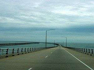
US 13 once again meets Interstate 64 shortly after entering Northampton Boulevard, entering the independent city of Virginia Beach just beyond the interchange. SR 166 leaves at Diamond Springs Road, leaving US 13 to bear north alone toward the Chesapeake Bay Bridge-Tunnel. The route bridges the Little Creek Reservoir on a causeway and turns to the north, interchanging with Virginia State Route 225 at a cloverleaf interchange and U.S. Route 60 at a diamond. US 60 is the last exit from US 13 before the Chesapeake Bay Bridge-Tunnel toll plaza, after which point the highway raises over the beach and passes across the 17.4-mile (28.0 km) span over and under the mouth of the Chesapeake Bay. Along the bridge, the mile markers change to reflect the length of the bridge, not the miles along US 13. The Bridge-Tunnel drops the route on the Delmarva Peninsula's Eastern Shore of Virginia.
On the Eastern Shore, US 13 is the main north–south highway in the region, and carries the name Charles M. Lankford, Jr. Highway (usually shortened to Lankford Highway). The Eastern Shore routing is a divided highway, passing through mostly farmland and small communities, though US 13 does have bypasses of most of the communities, such as Exmore and Onley. Near Oak Hall, Virginia State Route 175 leaves the route to the east, bearing toward Chincoteague. From there, the route curves slightly to the west and passes into Maryland between New Church and Pocomoke City, Maryland.
Whaleyville Bypass
As part of the Suffolk 2026 Comprehensive Plan, the city plans to bypass the crossroads community of Whaleyville in southwestern Suffolk City. US 13 (along with NC Highway 11) is a strategic highway corridor in North Carolina towards Greenville.[1][2]
History
_Historical_Marker.jpg)
What is now US 13 on the Eastern Shore was added to the state highway system in 1918 as State Route 4. It was renumbered State Route 34 in the 1923 renumbering, and US 13 was applied to its whole length in 1926. SR 34 was dropped in the 1933 renumbering, and was immediately reused on a route through Lawrenceville. That was renumbered to State Route 46 in the 1940 renumbering, and the current State Route 34 was designated in the late 1940s.
Before the Chesapeake Bay Bridge-Tunnel, US 13 continued across the Chesapeake Bay using a ferry.
Major intersections
| County | Location | mi | km | Destinations | Notes |
|---|---|---|---|---|---|
| City of Suffolk | 0.00 | 0.00 | North Carolina state line | ||
| 0.94 | 1.51 | Arthur Drive - Somerton | Former SR 643 | ||
| 4.75 | 7.64 | Mineral Springs Road - Holland | Former SR 616 | ||
| 11.80 | 18.99 | South end of SR 32 overlap | |||
| 11.91 | 19.17 | Old Somerton Road / Airport Road - Suffolk Municipal Airport | Former SR 646 | ||
| 13.16 | 21.18 | Interchange; north end of SR 32 overlap; south end of freeway | |||
| Northbound exit and southbound entrance | |||||
| 15.41 | 24.80 | South end of US 58 overlap | |||
| 16.91 | 27.21 | ||||
| 18.35 | 29.53 | South end of US 460 overlap | |||
| 19.23 | 30.95 | ||||
| 20.85 | 33.55 | ||||
| 22.53 | 36.26 | Interchange; southbound exit and northbound entrance; north end of freeway | |||
| City of Chesapeake | 27.97 | 45.01 | I-664 exit 13; north end of US 58 overlap; south end of I-664 overlap (northbound only) | ||
| West Military Highway | Interchange northbound; intersection southbound | ||||
| North end of I-664 overlap (northbound only); US 13 north follows exit 14 | |||||
| 30.97 | 49.84 | I-64 exit 297 | |||
| 32.03 | 51.55 | ||||
| Gilmerton Bridge over Southern Branch Elizabeth River | |||||
| 34.84 | 56.07 | Interchange; east end of US 460 overlap | |||
| 35.64 | 57.36 | I-464 exit 2 | |||
| 36.70 | 59.06 | Interchange | |||
| City of Virginia Beach | 39.39 | 63.39 | Providence Road | Former SR 409 east | |
| 39.82 | 64.08 | Indian River Road | Former SR 407 | ||
| City of Norfolk | 41.44 | 66.69 | I-264 exit 13 | ||
| 42.19 | 67.90 | Interchange | |||
| 43.51 | 70.02 | South end of SR 165 / SR 166 overlap | |||
| 43.76 | 70.42 | North end of SR 165 overlap | |||
| 44.26 | 71.23 | I-64 exit 282; no access from US 13 north to I-64 west or I-64 east to US 13 south | |||
| City of Virginia Beach | 45.44 | 73.13 | North end of SR 166 overlap | ||
| 47.32 | 76.15 | Interchange | |||
| 48.20 | 77.57 | Interchange | |||
| Chesapeake Bay | 49.26 | 79.28 | Chesapeake Bay Bridge-Tunnel | ||
| Northampton | Kiptopeke | Former SR 186 north | |||
| | Former SR 186 south | ||||
| Cape Junction | 75.53 | 121.55 | |||
| Cheriton | 77.09 | 124.06 | |||
| Stumptown | 80.00 | 128.75 | |||
| Eastville | 81.30 | 130.84 | Former SR 185 east | ||
| | 82.11 | 132.14 | |||
| Nassawadox | Former SR 184 west | ||||
| Exmore | 92.97 | 149.62 | |||
| 94.47 | 152.03 | ||||
| 94.91 | 152.74 | ||||
| 95.22 | 153.24 | Lincoln Avenue (US 13 Bus. south) | |||
| Accomack | Belle Haven Station | ||||
| Painter | |||||
| Keller | South end of SR 180 overlap | ||||
| North end of SR 180 overlap | |||||
| | |||||
| Onley | 105.71 | 170.12 | |||
| 106.33 | 171.12 | ||||
| | interchange | ||||
| | 108.14 | 174.03 | |||
| Accomac | Former SR 177 | ||||
| | 110.42 | 177.70 | |||
| Centerville | 112.36 | 180.83 | |||
| Nelsonia | 116.66 | 187.75 | |||
| Temperanceville | 122.07 | 196.45 | Former SR 288 west | ||
| Oak Hall | Former SR 175 west | ||||
| Nash Corner | 125.38 | 201.78 | |||
| | 129.06 | 207.70 | Maryland state line | ||
| 1.000 mi = 1.609 km; 1.000 km = 0.621 mi | |||||
See also
- Virginia State Route 13
- State Route 341, Centerville west to Parksley, now State Route 176
- State Route 342, Tasley west to Onancock, now State Route 126
- State Route 343, Eastville east to the Eastern Shore Railroad, now part of State Route 631
References
- ↑ "City of Suffolk, Virginia". Suffolkva.us. 2006-04-05. Retrieved 2012-08-15.
- ↑ "Archived copy". Archived from the original on May 19, 2012. Retrieved July 29, 2012.
External links
| Wikimedia Commons has media related to U.S. Route 13 in Virginia. |
| Previous state: North Carolina |
Virginia | Next state: Maryland |