Tzrufa
| Tzrufa | |
|---|---|
 Tzrufa | |
| Coordinates: 32°38′55.31″N 34°56′42.35″E / 32.6486972°N 34.9450972°ECoordinates: 32°38′55.31″N 34°56′42.35″E / 32.6486972°N 34.9450972°E | |
| District | Haifa |
| Council | Hof HaCarmel |
| Affiliation | Moshavim Movement |
| Founded | 1949 |
| Founded by |
Algerian and Tunisian immigrants |
| Population (2015)[1] | 1,093 |
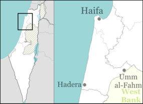
Tzrufa (Hebrew: צְרוּפָה) is a moshav in northern Israel. Located near Atlit, it falls under the jurisdiction of Hof HaCarmel Regional Council. In 2015 it had a population of 1,093.
History
The village was established in 1949 by immigrants from Algeria and Tunisia. Some writers opine that it was named after the depopulated Arab village of al-Sarafand on whose lands it was built.[2][3] Others point to the inscription at the village entrance which states ""The word of the Lord is pure [tzrufa]; He is a shield to all them that take refuge in him" (Psalms 18:30)."[4] During the Crusader period, the village was known as Sarepta Yudee, possibly to distinguish it from Sarepta of Lebanon. Both names means "smelting place."[5] Roman and Byzantine pottery remains have been found on site. During the Crusader era, a fortress and chapel were built. The remains of the village mosque can still be seen.[4]
References
- ↑ "List of localities, in Alphabetical order" (PDF). Israel Central Bureau of Statistics. Retrieved 16 October 2016.
- ↑ Khalidi, Walid (1992), All That Remains: The Palestinian Villages Occupied and Depopulated by Israel in 1948, Washington D.C.: Institute for Palestine Studies, p. 188, ISBN 0-88728-224-5
- ↑ Morris, Benny (2004). The Birth of the Palestinian Refugee Problem Revisited. Cambridge University Press. p. xxii. ISBN 978-0-521-00967-6.
- 1 2 Nakba 2.0: A somber trip down memory lane with an Israeli app G194
- ↑ Zarephath Bible Hub