1976 Pacific typhoon season
| |
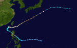
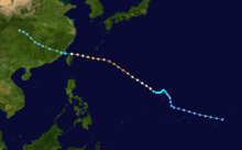
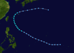
| Season summary map |
| First system formed |
January 26, 1976 |
| Last system dissipated |
December 30, 1976 |
| Strongest storm1 |
Louise – 895 hPa (mbar), 260 km/h (160 mph) (1-minute sustained) |
| Total depressions |
30 |
| Total storms |
25 |
| Typhoons |
14 |
| Super typhoons |
4 |
| Total fatalities |
Unknown |
| Total damage |
Unknown |
| 1Strongest storm is determined by lowest pressure |
Pacific typhoon seasons
1974, 1975, 1976, 1977, 1978 |
The 1976 Pacific typhoon season has no official bounds; it ran year-round in 1976, but most tropical cyclones tend to form in the northwestern Pacific Ocean between June and December. These dates conventionally delimit the period of each year when most tropical cyclones form in the northwestern Pacific Ocean.
The scope of this article is limited to the Pacific Ocean, north of the equator and west of the international date line. Storms that form east of the date line and north of the equator are called hurricanes; see 1976 Pacific hurricane season. Tropical Storms formed in the entire west pacific basin were assigned a name by the Joint Typhoon Warning Center. Tropical depressions in this basin have the "W" suffix added to their number. Tropical depressions that enter or form in the Philippine area of responsibility are assigned a name by the Philippine Atmospheric, Geophysical and Astronomical Services Administration or PAGASA. This can often result in the same storm having two names.
Storms
25 tropical storms formed this year in the Western Pacific. 14 storms reached typhoon intensity, of which 4 reached super typhoon strength.[1]
Typhoon Kathy
| Category 1 typhoon (SSHWS) |
|
|
| Duration |
January 26 – February 2 |
| Peak intensity |
150 km/h (90 mph) (1-min) 965 hPa (mbar) |
Tropical Depression Asiang
| Tropical depression (PAGASA) |
|
|
| Duration |
January 26 – February 1 |
| Peak intensity |
55 km/h (35 mph) (10-min) |
Tropical Depression Biring
| Tropical depression (PAGASA) |
|
|
| Duration |
February 8 – February 11 |
| Peak intensity |
55 km/h (35 mph) (10-min) |
Tropical Storm Lorna
| Tropical storm (SSHWS) |
|
|
| Duration |
February 25 – March 3 |
| Peak intensity |
65 km/h (40 mph) (1-min) 998 hPa (mbar) |
Typhoon Marie (Konsing)
| Category 4 typhoon (SSHWS) |
|
|
| Duration |
April 1 – April 16 |
| Peak intensity |
215 km/h (130 mph) (1-min) 930 hPa (mbar) |
Tropical Storm Nancy
| Tropical storm (SSHWS) |
|
|
| Duration |
April 24 – May 3 |
| Peak intensity |
100 km/h (65 mph) (1-min) 985 hPa (mbar) |
Typhoon Olga (Didang)
| Category 3 typhoon (SSHWS) |
|
|
| Duration |
May 10 – May 28 |
| Peak intensity |
185 km/h (115 mph) (1-min) 940 hPa (mbar) |
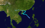
The monsoon trough spawned a tropical depression east of the Philippines on May 10. It tracked generally westward, reaching tropical storm status on the 13th while remaining poorly organized. On the 14th Olga relocated to the southeast, and regained tropical storm strength after weakening. The storm headed to the northwest, and looped in response to the approach of a long wave trough. After returning to a westward movement Olga, despite unfavorable wind shear, strengthened to a typhoon on the 20th. It rapidly intensified that night, and hit eastern Luzon early on the 21st as a 115 mph (185 km/h) typhoon. It drifted across the island, and turned northward in the South China Sea. Olga moved rapidly to the northeast, and on the 28th Olga was absorbed by a subtropical disturbance. Olga brought torrential flooding, at some points as much as 50 inches (1,300 mm) of rain. Because of this, 374 people were killed and thousands were left homeless. Olga also destroyed many of the sets used during the filming of Apocalypse Now.
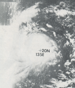
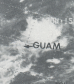
Super Typhoon Pamela
| Category 4 super typhoon (SSHWS) |
|
|
| Duration |
May 14 – May 29 |
| Peak intensity |
240 km/h (150 mph) (1-min) 920 hPa (mbar) |
The near equatorial trough produced a tropical depression on May 14 north of Chuuk. It moved southwestward, becoming a tropical storm on the 15th. Pamela slowly looped to the northwest, and reached typhoon status on the 16th. On the 18th and 19th, Pamela rapidly intensified to a 150 mph (240 km/h) super typhoon, and slowly weakened as it continued its northwest movement. On May 21 the typhoon crossed Guam with sustained winds of 140 mph (230 km/h). After slowly crossing the island, Pamela turned to the north, and weakened until becoming extratropical on the 26th. Pamela was the strongest typhoon to hit Guam since Super Typhoon Karen in 1962. Though Karen was much stronger, Pamela's slow crossing caused much more damage, amounting to $500 million (1976 USD, $1.7 billion 2005 USD). Well-executed warnings allowed for only one death in Guam. Before Typhoon Pamela hit Guam, ten people died in a landslide in Truk (Chuuk) from its heavy rains.
Tropical Depression Gloring
| Tropical depression (PAGASA) |
|
|
| Duration |
June 15 – June 18 |
| Peak intensity |
55 km/h (35 mph) (10-min) |
Typhoon Ruby (Huaning)
| Category 4 typhoon (SSHWS) |
|
|
| Duration |
June 20 – July 5 |
| Peak intensity |
220 km/h (140 mph) (1-min) 935 hPa (mbar) |
The monsoon trough spawned Tropical Depression 7W on June 20. It headed westward, slowly organizing into a tropical storm on the 23rd. Ruby turned to the northwest, and reached typhoon strength just before hitting Luzon on the 25th. It crossed the island, weakening to a tropical storm before turning to the northeast in the South China Sea. Ruby again became a typhoon on the 28th, and on July 2, the typhoon reached a peak of 140 mph (230 km/h) winds while south of Japan. The typhoon turned to the east, and became extratropical on the 3rd. 16 people were killed from the typhoon.
Typhoon Sally (Isang)
| Category 4 typhoon (SSHWS) |
|
|
| Duration |
June 24 – July 5 |
| Peak intensity |
215 km/h (130 mph) (1-min) 925 hPa (mbar) |
Super Typhoon Therese
| Category 4 super typhoon (SSHWS) |
|
|
| Duration |
July 8 – July 21 |
| Peak intensity |
250 km/h (155 mph) (1-min) 905 hPa (mbar) |
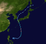
Typhoon Therese, which developed on July 8, explosively deepened on the 12th and 13th to a 155 mph (249 km/h) super typhoon. Therese weakened as it continued to the northwest, and struck southwest Japan on the 19th as a tropical storm. It looped to the west, and dissipated on the 21st. Therese caused heavy flooding, killing 3 people and causing millions in damage.
Tropical Storm Violet (Lusing)
| Tropical storm (SSHWS) |
|
|
| Duration |
July 20 – July 27 |
| Peak intensity |
100 km/h (65 mph) (1-min) 985 hPa (mbar) |
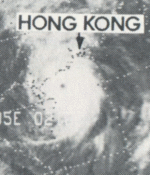
Tropical Storm Violet struck Hong Kong and Hainan Island killing 2 people.[2]
Tropical Storm Wilda
| Tropical storm (SSHWS) |
|
|
| Duration |
July 17 – July 24 |
| Peak intensity |
85 km/h (50 mph) (1-min) 985 hPa (mbar) |
Typhoon Anita (Maring)
| Category 1 typhoon (SSHWS) |
|
|
| Duration |
July 20 – July 27 |
| Peak intensity |
120 km/h (75 mph) (1-min) 980 hPa (mbar) |
Typhoon Billie (Nitang)
| Category 4 typhoon (SSHWS) |
|
|
| Duration |
July 31 – August 12 |
| Peak intensity |
230 km/h (145 mph) (1-min) 915 hPa (mbar) |
When 105 mph (169 km/h) Typhoon Billie hit eastern Taiwan and China, it caused heavy flooding and wind damage, amounting to 4 casualties (with 8 missing and 41 drownings) and $2.6 million in damage (1976 USD).
Tropical Storm Clara
| Tropical storm (SSHWS) |
|
|
| Duration |
August 2 – August 8 |
| Peak intensity |
75 km/h (45 mph) (1-min) 985 hPa (mbar) |
Tropical Storm Dot (Osang)
| Tropical storm (SSHWS) |
|
|
| Duration |
August 17 – August 24 |
| Peak intensity |
95 km/h (60 mph) (1-min) 990 hPa (mbar) |
Tropical Storm Ellen (Paring)
| Tropical storm (SSHWS) |
|
|
| Duration |
August 20 – August 25 |
| Peak intensity |
85 km/h (50 mph) (1-min) 992 hPa (mbar) |
Tropical Storm Ellen struck Hong Kong killing 27 people and left 3 missing.[2]
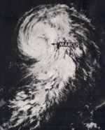
Super Typhoon Fran (Reming)
| Category 4 super typhoon (SSHWS) |
|
|
| Duration |
September 2 – September 15 |
| Peak intensity |
240 km/h (150 mph) (1-min) 910 hPa (mbar) |
An area of disturbed weather organized into Tropical Depression 17W on September 2. It tracked northwestward, becoming a tropical storm on the 4th and a typhoon on the 6th. Fran rapidly intensified to a 150 mph (240 km/h) super typhoon on the 7th, and weakened as it turned northward. After stalling and drifting to the west, Fran continued its northward movement, hit southwestern Japan on the 12th, and became extratropical in the Sea of Japan on the 13th. The storm caused heavy flooding and wind damage, causing 133 fatalities (with 32 missing) and $572 million in damage (1976 USD, $1.9 billion in 2005 USD), the worst Japanese typhoon in over 10 years.
Tropical Storm Georgia
| Tropical storm (SSHWS) |
|
|
| Duration |
September 8 – September 16 |
| Peak intensity |
75 km/h (45 mph) (1-min) 990 hPa (mbar) |
Typhoon Hope
| Category 1 typhoon (SSHWS) |
|
|
| Duration |
September 13 – September 19 |
| Peak intensity |
130 km/h (80 mph) (1-min) 965 hPa (mbar) |
Tropical Depression Seniang
| Tropical depression (PAGASA) |
|
|
| Duration |
September 13 – September 14 |
| Peak intensity |
55 km/h (35 mph) (10-min) |
Typhoon Iris (Toyang)
| Category 1 typhoon (SSHWS) |
|
|
| Duration |
September 14 – September 29 |
| Peak intensity |
140 km/h (85 mph) (1-min) 975 hPa (mbar) |
Typhoon Joan
| Category 1 typhoon (SSHWS) |
|
|
| Duration |
September 18 – September 25 |
| Peak intensity |
130 km/h (80 mph) (1-min) 965 hPa (mbar) |
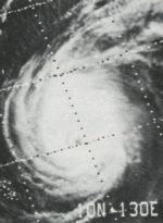
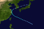
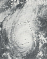
Super Typhoon Louise (Welpring)
| Category 5 super typhoon (SSHWS) |
|
|
| Duration |
October 27 – November 9 |
| Peak intensity |
260 km/h (160 mph) (1-min) 895 hPa (mbar) |
Tropical Storm Marge (Yoning)
| Tropical storm (SSHWS) |
|
|
| Duration |
November 4 – November 12 |
| Peak intensity |
110 km/h (70 mph) (1-min) 975 hPa (mbar) |
Tropical Storm Nora (Aring)
| Tropical storm (SSHWS) |
|
|
| Duration |
December 1 – December 8 |
| Peak intensity |
85 km/h (50 mph) (1-min) 990 hPa (mbar) |
Tropical Storm Opal (Basiang)
| Tropical storm (SSHWS) |
|
|
| Duration |
December 8 – December 10 |
| Peak intensity |
65 km/h (40 mph) (1-min) 995 hPa (mbar) |
Tropical Depression Kayang
| Tropical depression (PAGASA) |
|
|
| Duration |
December 29 – December 30 |
| Peak intensity |
55 km/h (35 mph) (10-min) |
1976 storm names
Western North Pacific tropical cyclones were named by the Joint Typhoon Warning Center. The first storm of 1976 was named Kathy and the final one was named Opal.
-
Agnes
-
Bonnie
-
Carmen
-
Della
-
Elaine
-
Faye
-
Gloria
-
Hester
-
Irma
-
Judy
-
Kit
-
Lola
-
Mamie
-
Nina
-
Ora
-
Phyllis
-
Rita
-
Susan
-
Tess
-
Viola
-
Winnie
|
-
Alice
-
Betty
-
Cora
-
Doris
-
Elsie
-
Flossie
-
Grace
-
Helen
-
Ida
-
June
- Kathy 1W
- Lorna 2W
- Marie 3W
- Nancy 4W
- Olga 5W
- Pamela 6W
- Ruby 7W
- Sally 8W
- Therese 9W
- Violet 10W
- Wilda 11W
|
- Anita 12W
- Billie 13W
- Clara 14W
- Dot 15W
- Ellen 16W
- Fran 17W
- Georgia 18W
- Hope 19W
- Iris 20W
- Joan 21W
- Kate 22C
- Louise 23W
- Marge 24W
- Nora 25W
- Opal 26W
-
Patsy
-
Ruth
-
Sarah
-
Thelma
-
Vera
-
Wanda
|
-
Amy
-
Babe
-
Carla
-
Dinah
-
Emma
-
Freda
-
Gilda
-
Harriet
-
Ivy
-
Jean
-
Kim
-
Lucy
-
Mary
-
Nadine
-
Olive
-
Polly
-
Rose
-
Shirley
-
Trix
-
Virginia
-
Wendy
|
One Central Pacific system developed, Hurricane Kate. The policy at the time was to use Western Pacific names the Central Pacific.
Philippines
The Philippine Atmospheric, Geophysical and Astronomical Services Administration (PAGASA) used its own naming scheme for tropical cyclones within its area of responsibility. Lists were recycled every four years. This is the same list used for the 1972 season.
- Asiang
- Biring
- Konsing
- Ditang
- Edeng
|
- Gloring
- Huaning
- Isang
- Lusing
- Maring
|
- Nitang
- Osang
- Paring
- Reming
- Seniang
|
- Toyang
- Undang
- Welpring
- Yoning
- Aring
|
- Basiang
-
Kayang (unused)
-
Dorang (unused)
-
Enang (unused)
-
Grasing (unused)
|
See also
References
- ↑ 1976 ATCR TABLE OF CONTENTS
- 1 2 Historical Information
External links