Tygart Valley River
| Tygart Valley River | |
 The Tygart Valley River at the mouth of the Buckhannon River (just above center). Photo taken along the B&O Railroad between Belington and Philippi. | |
| Country | United States |
|---|---|
| State | West Virginia |
| Counties | Barbour, Marion, Pocahontas, Taylor, Randolph |
| Tributaries | |
| - left | Middle Fork River, Buckhannon River |
| Source | Allegheny Mountains |
| - location | Pocahontas County, WV |
| - elevation | 4,540 ft (1,384 m) [1] |
| - coordinates | 38°28′06″N 79°58′51″W / 38.46833°N 79.98083°W [2] |
| Mouth | Monongahela River |
| - location | Fairmont, WV |
| - elevation | 863 ft (263 m) [2] |
| - coordinates | 39°27′54″N 80°09′11″W / 39.46500°N 80.15306°WCoordinates: 39°27′54″N 80°09′11″W / 39.46500°N 80.15306°W [2] |
| Length | 135 mi (217 km) [3] |
| Basin | 1,329 sq mi (3,442 km2) [4] |
| Discharge | for Philippi, WV |
| - average | 1,922 cu ft/s (54 m3/s) [5] |
| - max | 61,000 cu ft/s (1,727 m3/s) |
| - min | 4.9 cu ft/s (0 m3/s) |
| Discharge elsewhere (average) | |
| - near Dailey, WV | 358 cu ft/s (10 m3/s) [5] |
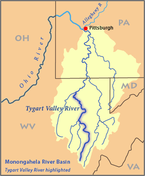 Map of the Monongahela River basin, with the Tygart Valley River highlighted | |

The Tygart Valley River — also known as the Tygart River — is a principal tributary of the Monongahela River, approximately 135 miles (217 km) long,[3] in east-central West Virginia in the United States. Via the Monongahela and Ohio rivers, it is part of the watershed of the Mississippi River, draining an area of 1,329 square miles (3,440 km2) in the Allegheny Mountains and the unglaciated portion of the Allegheny Plateau.
Course
The Tygart Valley River rises in the Allegheny Mountains in Pocahontas County and flows generally north-northwestwardly through Randolph, Barbour, Taylor and Marion counties, past the towns of Huttonsville, Mill Creek, Beverly, Elkins, Junior, Belington, Philippi, Arden, and Grafton, to Fairmont, where it joins the West Fork River to form the Monongahela River.[6] Downstream of Elkins, the Tygart Valley River passes through a gap between Rich Mountain and Laurel Mountain, which are considered to be part of the westernmost ridge of the Allegheny Mountains and the boundary between the Alleghenies and the Allegheny Plateau.[4][7]
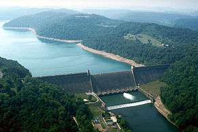
Along its course the river collects Leading Creek at Elkins; the Middle Fork River and the Buckhannon River (its largest tributary)[4] in Barbour County; and Sandy Creek and Three Fork Creek in Taylor County.[6] Just upstream of Grafton, the river was impounded by a U.S. Army Corps of Engineers dam in 1938 to form Tygart Lake.[8] Valley Falls State Park is along the river between Grafton and Fairmont.[6][9]
Flow rate
At the United States Geological Survey's stream gauge in Philippi, the annual mean flow of the river between 1940 and 2005 was 1,922 ft³/s (54 m³/s). The river's highest flow during the period was estimated at 61,000 ft³/s (1,727 m³/s) on November 5, 1985. The lowest recorded flow was 4.9 ft³/s (0.1 m³/s) on several days in October 1953.
At an upstream gauge near the community of Dailey in Randolph County, the annual mean flow of the river between 1915 and 2005 was 358 ft³/s (10 m³/s). The highest recorded flow during the period was 19,900 ft³/s (564 m³/s) on May 17, 1996. Readings of zero were recorded for several months during autumn of the years 1930 and 1953.[5]
History
The Tygart Valley was first settled by Europeans in 1753 when David Tygart (for whom the valley and river are named) and Robert Files (or Foyle) located (separately) with their families in the vicinity of present-day Beverly. Although there had been no recent history of conflicts between whites and Indians in that immediate area, that summer a party of Indians traveling the Shawnee Trail discovered the Files cabin and killed seven members of the family. One son escaped and alerted the Tygart family, allowing all to escape. No other white settlement was attempted in present Randolph County until 1772. (It has been thought that Tygart was again among those settling then, but this is not certain).[10]
The brothers John and Samuel Pringle, who had taken up residence along the Buckhannon tributary of the Tygart (in present Upshur County) in 1761, acted as their contemporary Daniel Boone was doing in Kentucky and guided numerous immigrant settlers into the main valley of the Tygart which at that time abounded in game and fertile bottomlands. Settlers of the 1770s and '80s included the Connelly, Hadden, Jackson, Nelson, Riffle, Stalnaker, Warwick, Westfall, Whiteman and Wilson families.[11] (One settler, John Jackson [1715–1801] from County Londonderry, Ireland, was great-grandfather to Thomas "Stonewall" Jackson.)
Several minor actions occurred in the Valley during the American Civil War,[12] including the Battle of Philippi, the Battle of Laurel Hill and the Battle of Cheat Mountain, all in 1861.
Variant names and spellings
The United States Board on Geographic Names settled on "Tygart River" as the stream's name in 1902, and changed it to "Tygart Valley River" in 1950. According to the Geographic Names Information System, the Tygart Valley River has also been known historically as:[2]
|
|
|
See also
References
Citations
- ↑ Google Earth elevation for GNIS source coordinates. Retrieved on March 12, 2007.
- 1 2 3 4 Geographic Names Information System. "Geographic Names Information System entry for Tygart Valley River (Feature ID #1553309)". Retrieved 2007-03-12.
- 1 2 U.S. Geological Survey. National Hydrography Dataset high-resolution flowline data. The National Map, accessed August 15, 2011
- 1 2 3 Rice, Donald L. (2006). "Tygart Valley River". In Ken Sullivan (ed.). The West Virginia Encyclopedia. Charleston, W.Va.: West Virginia Humanities Council. p. 721. ISBN 0-9778498-0-5.
- 1 2 3 Ward, S. M.; G. R. Crosby. "Water Resources Data, West Virginia, Water Year 2005". United States Geological Survey. pp. Monongahela River Basin. Retrieved 2007-05-20.
- 1 2 3 West Virginia Atlas & Gazetteer. Yarmouth, Me.: DeLorme. 1997. pp. 25–26, 36–37, 47. ISBN 0-89933-246-3.
- ↑ Adkins, Howard G. (2006). "Allegheny Mountains". In Ken Sullivan (ed.). The West Virginia Encyclopedia. Charleston, W.Va.: West Virginia Humanities Council. p. 10. ISBN 0-9778498-0-5.
- ↑ United States Army Corps of Engineers. "Tygart Lake". Retrieved 2007-03-12.
- ↑ "Valley Falls State Park". Retrieved 2007-03-12.
- ↑ Maxwell, Hu (1899). The History of Barbour County, From its Earliest Exploration and Settlement to the Present Time, The Acme Publishing Company, Morgantown, W.Va. (Reprinted, McClain Printing Company, Parsons, W.Va., 1968). pp. 180–181.
- ↑ Rice, Otis K. and Stephen W. Brown (1993). West Virginia, A History, 2nd Edition, The University Press of Kentucky, Lexington, Kentucky. p. 29.
- ↑ Carnes, Eva Margaret, The Tygarts Valley Line, June–July 1861, "Published by the First Land Battle of the Civil War Centennial Commemoration, Inc. Philippi, West Virginia", 1961. (Reprinted 1988, 2003; McClain Printing Company, Parsons, West Virginia) ISBN 0-87012-703-9.
Other sources
- Hamilton, Carolyn Fortney (2004), West Virginia's Lower Tygart Valley River: People and Places, Terra Alta, West Virginia: Headline Books, Inc.