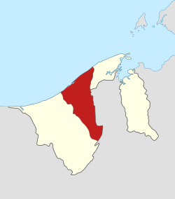
Tutong District
| Tutong | |
|---|---|
| District | |
 | |
| Capital | Pekan Tutong |
| Area | |
| • Tutong District | 1,166 km2 (450 sq mi) |
| Population (2011) | |
| • Tutong District | 43,852 |
| • Density | 38/km2 (97/sq mi) |
| Human Development Index | |
Tutong is a district (daerah in the Malay language) in Brunei and its capital is Pekan Tutong or Tutong Town (in English). The district borders the South China Sea to the north, the Bruneian district of Brunei and Muara and the Malaysian state of Sarawak to the east and the Bruneian district of Belait to the west. It has a population of 35,200, and covers 1,303 km² (503 mi²). The Sungai Tutong river flows through Tutong. Although bigger size than Brunei-Muara District with 1,166 km2 of territory, Tutong has a population of only around 34,100 including members of Borneo's ethnic tribes such as Tutong, Kedayan, Murut, Malay, Chinese and Dusun.
Subdistricts
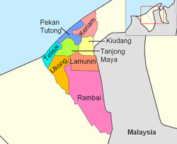
Tutong district is divided into 8 sub-districts (mukim), namely:
Education
There are several government schools and a few private schools in the district, which offer primary, secondary and post-secondary (sixth form) education.
Government schools
The government schools are mainly administered under the Ministry of Education. There are 30 primary schools, 5 secondary schools and one sixth form college in the district, which are grouped under Cluster 6 of the Ministry's school administrative district.[1]
The five secondary schools are:
- Muda Hashim Secondary School;
- Raja Isteri Pengiran Anak Saleha Secondary School;
- Sayyidina 'Othman Secondary School;
- Sufri Bolkiah Secondary School; and
- Tanjong Maya Secondary School.
These schools offer secondary education that leads to Brunei-Cambridge GCE O Level.[2]
The sole sixth form college of the district is the Tutong Sixth Form Centre and offers sixth form education which leads to GCE A Level.[3]
Private schools
There are six private schools in the district, namely:[4]
- Chung Hwa School, Tutong;
- Chung Hwa School, Kiudang;
- Tutong Public School;
- Nusa Jaya School, Penanjong;
- Nusa Jaya School, Keriam; and
- Pertama Primary School.
All of the private schools above offer kindergarten and primary education.
Places of Interest in Tutong District
Tutong has the largest lake in Brunei, Tasek Merimbun, which is surrounding the Tasek Merimbun Heritage Park.[5]
Other places of interest in Tutong:
- Sungai Basong Recreation Park
- Seri Kenangan Beach
References
- ↑ "Government". Ministry of Education, Brunei Darussalam. Retrieved September 10, 2016.
- ↑ "Secondary Education". Ministry of Education, Brunei Darussalam. Retrieved September 10, 2016.
- ↑ "Post Secondary Education". Ministry of Education, Brunei Darussalam. Retrieved September 10, 2016.
- ↑ "Private". Ministry of Education, Brunei Darussalam. Retrieved September 10, 2016.
- ↑ Tasek Merimbun Heritage Park
Coordinates: 4°35′N 114°40′E / 4.583°N 114.667°E