Turon de Néouvielle
| Turon de Néouvielle | |
|---|---|
 | |
| Highest point | |
| Elevation | 3,035 m (9,957 ft) |
| Coordinates | 42°49′41″N 0°06′27″E / 42.82806°N 0.10750°ECoordinates: 42°49′41″N 0°06′27″E / 42.82806°N 0.10750°E |
| Geography | |
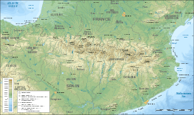 Turon de Néouvielle Pyrenees | |
| Location | Hautes-Pyrénées, France |
| Parent range | Néouvielle massif |
| Climbing | |
| First ascent | 15 August 1787 Jean-Joseph Vidal and Henri Reboul |
The Turon du Néouvielle is a summit in the French Pyrenees, culminating at 3,035 m, located in the Néouvielle Range, on the edge of the Pyrenees National Park. It is famous for having the first recorded ascent of a Pyrenees peak over 3,000 metres.[1]
History
In 1787, on the second of August, Jean-Joseph Vidal, an astronomer from Mirepoix, and the chemist Henri Reboul from Toulouse, who was studying the snowmass in the Pyrenees, made the first recorded ascent.[2][3] They gave their names to the rocky ridge which extends from the crest of Turon towards Cap-de-Long Lake.
Access
The peak is easily accessible from Barèges, going past the alpine "hut" of Refuge de la Glère, by Lake Glère.[4]
See also
References
- ↑ List of peaks in the Pyrenees by date of ascent
- ↑ Rouche, Martine (24 April 2010). "2e journée de printemps de l'histoire locale à Mirepoix". Ariège News. Archived from the original on 8 June 2014.
- ↑ Grao, Jean-Paul (2013). Henri Reboul: l'aube du pyrénéisme (in French). Pau, France: MonHélios,. ISBN 9791090065277.
- ↑ "Refuge de la Glère". Pyrēnēes cabanes et refuges.
External links
- "Aerial view of Turon de Néouvielle". Google Maps.
- "Photo: Position of Turon in the Néouvielle Range".
This article is issued from Wikipedia - version of the 7/16/2015. The text is available under the Creative Commons Attribution/Share Alike but additional terms may apply for the media files.