Tupman, California
| Tupman | |
|---|---|
| census-designated place | |
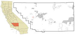 Location in Kern County and the state of California | |
 Tupman Location in the United States | |
| Coordinates: 35°17′53″N 119°21′04″W / 35.29806°N 119.35111°WCoordinates: 35°17′53″N 119°21′04″W / 35.29806°N 119.35111°W | |
| Country |
|
| State |
|
| County | Kern |
| Government | |
| • Senate | Roy Ashburn (R) |
| • Assembly | Jean Fuller (R) |
| • U. S. Congress | Kevin McCarthy (R) |
| Area[1] | |
| • Total | 0.528 sq mi (1.367 km2) |
| • Land | 0.528 sq mi (1.367 km2) |
| • Water | 0 sq mi (0 km2) 0% |
| Elevation[2] | 331 ft (101 m) |
| Population (2010) | |
| • Total | 161 |
| • Density | 300/sq mi (120/km2) |
| Time zone | PST (UTC-8) |
| • Summer (DST) | PDT (UTC-7) |
| ZIP code | 93276 |
| Area code(s) | 661 |
| FIPS code | 06-80784 |
| GNIS feature ID | 1661588 |
Tupman is a census-designated place (CDP) in Kern County, California, United States. Tupman is located 20 miles (32 km) west-southwest of Bakersfield,[3] at an elevation of 331 feet (101 m).[2] The population was 161 at the 2010 census, down from 227 at the 2000 census.
Geography
According to the United States Census Bureau, the CDP has a total area of 0.5 square miles (1.3 km2), all of it land.
History
In 1920, Standard Oil Company bought the land from H.V. Tupman and founded the town.[3] The first post office at Tupman opened in 1921.[3]
Demographics
2010
The 2010 United States Census[4] reported that Tupman had a population of 161. The population density was 305.0 people per square mile (117.8/km²). The racial makeup of Tupman was 149 (92.5%) White, 0 (0.0%) African American, 0 (0.0%) Native American, 0 (0.0%) Asian, 0 (0.0%) Pacific Islander, 2 (1.2%) from other races, and 10 (6.2%) from two or more races. Hispanic or Latino of any race were 12 persons (7.5%).
The Census reported that 161 people (100% of the population) lived in households, 0 (0%) lived in non-institutionalized group quarters, and 0 (0%) were institutionalized.
There were 55 households, out of which 24 (43.6%) had children under the age of 18 living in them, 26 (47.3%) were opposite-sex married couples living together, 12 (21.8%) had a female householder with no husband present, 4 (7.3%) had a male householder with no wife present. There were 3 (5.5%) unmarried opposite-sex partnerships, and 0 (0%) same-sex married couples or partnerships. 8 households (14.5%) were made up of individuals and 2 (3.6%) had someone living alone who was 65 years of age or older. The average household size was 2.93. There were 42 families (76.4% of all households); the average family size was 3.29.
The population was spread out with 45 people (28.0%) under the age of 18, 19 people (11.8%) aged 18 to 24, 34 people (21.1%) aged 25 to 44, 46 people (28.6%) aged 45 to 64, and 17 people (10.6%) who were 65 years of age or older. The median age was 32.5 years. For every 100 females there were 106.4 males. For every 100 females age 18 and over, there were 114.8 males.
There were 73 housing units at an average density of 138.3 per square mile (53.4/km²), of which 34 (61.8%) were owner-occupied, and 21 (38.2%) were occupied by renters. The homeowner vacancy rate was 0%; the rental vacancy rate was 12.5%. 103 people (64.0% of the population) lived in owner-occupied housing units and 58 people (36.0%) lived in rental housing units.
2000
As of the census[5] of 2000, there were 227 people, 66 households, and 53 families residing in the CDP. The population density was 426.0 people per square mile (165.4/km²). There were 75 housing units at an average density of 140.8 per square mile (54.6/km²). The racial makeup of the CDP was 92.95% White, 0.44% Black or African American, 0.88% Native American, 2.64% from other races, and 3.08% from two or more races. 6.17% of the population were Hispanic or Latino of any race.
There were 66 households out of which 37.9% had children under the age of 18 living with them, 53.0% were married couples living together, 25.8% had a female householder with no husband present, and 18.2% were non-families. 18.2% of all households were made up of individuals and 3.0% had someone living alone who was 65 years of age or older. The average household size was 3.44 and the average family size was 3.76.
In the CDP the population was spread out with 37.9% under the age of 18, 8.4% from 18 to 24, 27.8% from 25 to 44, 20.7% from 45 to 64, and 5.3% who were 65 years of age or older. The median age was 30 years. For every 100 females there were 97.4 males. For every 100 females age 18 and over, there were 101.4 males.
The median income for a household in the CDP was $27,500, and the median income for a family was $43,125. Males had a median income of $38,125 versus $28,750 for females. The per capita income for the CDP was $8,482. About 12.5% of families and 20.1% of the population were below the poverty line, including 9.3% of those under the age of eighteen and 42.9% of those sixty five or over.
Notable people
- Trice Harvey, former California State Assembly member.
Photos of the area
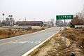 Post Office and guide sign.
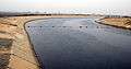 California Aqueduct near Tupman.
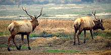 Tule Elk at the nearby reserve.
References
- ↑ U.S. Census
- 1 2 U.S. Geological Survey Geographic Names Information System: Tupman, California
- 1 2 3 Durham, David L. (1998). California's Geographic Names: A Gazetteer of Historic and Modern Names of the State. Clovis, Calif.: Word Dancer Press. p. 1120. ISBN 1-884995-14-4.
- ↑ "2010 Census Interactive Population Search: CA - Tupman CDP". U.S. Census Bureau. Retrieved July 12, 2014.
- ↑ "American FactFinder". United States Census Bureau. Retrieved 2008-01-31.
