Tunja
| Tunja | |||
|---|---|---|---|
| Municipality of Colombia | |||
|
Top left: night view of Tunja Bolivar Square; top right: House of Tunja Gonzalo Suarez Rendon; middle left: statue of Don Johan do Castellanos in Mayor Square; middle upper left: night view of Tunja Metropolitan Cathedral; middle lower right: the Boyaca Bridge in Boyaca Field; bottom: panorama view of Tunja, from north of hill | |||
| |||
 Location of Tunja in the department of Boyacá | |||
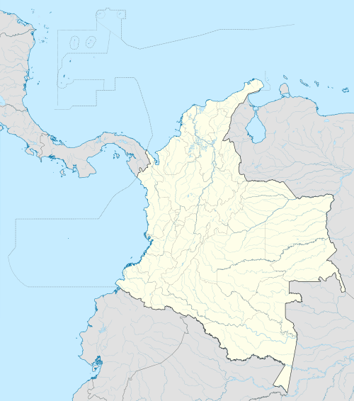 Tunja Location in Colombia | |||
| Coordinates: 5°32′N 73°22′W / 5.533°N 73.367°WCoordinates: 5°32′N 73°22′W / 5.533°N 73.367°W | |||
| Country | Colombia | ||
| Department | Boyacá | ||
| Province | Central Boyacá Province | ||
| Founded | 6 August 1539 | ||
| Established | March 29, 1541 | ||
| Founded by | Gonzalo Suárez Rendón | ||
| Government | |||
| • Mayor |
Pablo Emilio Cepeda Novoa (2016-2019) | ||
| Area | |||
| • Municipality of Colombia | 121.49 km2 (46.91 sq mi) | ||
| • Urban | 13 km2 (5 sq mi) | ||
| Elevation | 2,820 m (9,250 ft) | ||
| Population (2016) | |||
| • Municipality of Colombia | 191,878 | ||
| • Density | 1,600/km2 (4,100/sq mi) | ||
| • Urban | 184,080 | ||
| • Metro | 243,330 | ||
| [1] | |||
| Demonym(s) | Tunjano | ||
| Postal code | 150001-150009 | ||
| Area code(s) | 57 + 8 | ||
| Website | Official website (Spanish) | ||
| IGAC - DANE - DIAN. | |||


 |
| Muisca |
|---|
| Topics |
| Geography |
| The Salt People |
| Main neighbours |
| History & timeline |
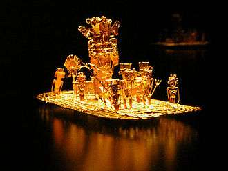
Tunja (Spanish pronunciation: [ˈtuŋxa]) is a city on the Eastern Ranges of the Colombian Andes, in the region known as the Altiplano Cundiboyacense, 130 km northeast of Bogotá. In 2012 it had an estimated population of 181,407 inhabitants.[1] It is the capital of Boyacá department and the Central Boyacá Province. Tunja is an important educational centre of known universities. In the time before the Spanish conquest of the Muisca, Tunja was called Hunza and was conquered by the Spanish conquistadors on August 20, 1537 upon zaque Quemuenchatocha and founded by the Spanish on August 6, 1539, exactly one year after the former southern capital Bacatá. The city hosts the most remaining Muisca architecture: Hunzahúa Well, Goranchacha Temple and Cojines del Zaque.
Tunja is a tourist destination, especially for religious colonial architecture, with the Casa Fundador Gonzalo Suárez Rendón as oldest remnant.[2] In addition to its religious and historical sites it is host to several internationally known festivals and is a jumping-off point for regional tourist destinations such as Villa de Leyva, Paipa, and Sierra Nevada del Cocuy. It is a stop on the Pan American Highway which connects Tunja to Bogotá and Santa Marta and eventually to the northern and southernmost parts of South America.
Demographics and geography
Tunja has a population of approximately 180,000 inhabitants and is located in central Colombia. The city centre is at an elevation of 2,820 metres (9,250 ft) above sea level.
Climate
Tunja's climate is influenced by its location and altitude. At almost 3000 m it is one of the higher cities in Colombia. As a result, the city features a subtropical highland climate (Köppen Cfb) with little variation in temperature throughout the year but a distinct dry season from December to February.
| | ||||||||||||||||||||||||||||||||||||||||||||||||||||||||||||
|---|---|---|---|---|---|---|---|---|---|---|---|---|---|---|---|---|---|---|---|---|---|---|---|---|---|---|---|---|---|---|---|---|---|---|---|---|---|---|---|---|---|---|---|---|---|---|---|---|---|---|---|---|---|---|---|---|---|---|---|---|
| Climate chart (explanation) | ||||||||||||||||||||||||||||||||||||||||||||||||||||||||||||
| ||||||||||||||||||||||||||||||||||||||||||||||||||||||||||||
| ||||||||||||||||||||||||||||||||||||||||||||||||||||||||||||
History
Pre-Columbian era
The earliest evidence of human population on the Altiplano Cundiboyacense has been dated to approximately 12.000 years ago. Homus Tequendama inhabited the area by 6375 BCE. Archeologists have found human skeletons including arm bones in the area. Many archaeological discoveries were found in the area of the present-day city, dated to approximately 150 BCE.
During the 1st millennium a.d., the territory was inhabited by the Muisca, who spoke Chibcha and emigrated from Central America through Panama to the Andean Region.[3] The Muisca developed their own religion, calendar and mythology.
According to those myths, it was the brutal cacique and prophet Goranchacha who moved the capital for the northern Muisca from Ramiriquí to Tunja, then called Hunza.
First Muisca era
An era when frequent battles among cacicazgos took place, peace was proposed for the region and an agreement was made among caciques to choose a supreme chief to rule them all. Hunzahúa, who came from Ramiriqui, was elected. The capital of his confederation was named Hunza. Hunzahúa took the title of zaque ("great lord", the same meaning as zipa who ruled from Bacatá), and reign over the lands from the Chicamocha to Fusagasugá and from the Llanos de San Juan to Panche and Muzo frontiers, including Vélez territory. This helped to unify the Muisca, especially with respect to their language and religion, until zipa Saguamanchica broke this unity due to differences with the cacique of Guatavita.[4]


Last Muisca era (1490–1539)
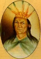
Saguamanchica, with 50,000 soldiers, decided on a massive attack on zaque Michuá,[5] crossing Guatavita and Chocontá, after which the Battle of Chocontá is named. Michuá dealt with him, supported by an army which doubled Saguamanchica, battling around three hours and killing both chiefs. A new zaque, Quemuenchatocha, was installed, during the tense truce between Bacatá and Hunza.
In 1514, Quemuenchatocha found out about the expansionist intentions of the new zipa Nemequene. He asked the caciques of Gámeza, Sugamuxi, Tundama and Sáchica to help him to reinforce his army. A battle was fought in Ventaquemada and, when Nemequene was about to become the victor, he was fatally wounded and his troops retreated. Iraca retracted his support and Quemuenchatocha got a truce whose terms would end when the Spanish arrived. When Quemuenchatocha found out the Europeans were around his lands, he decided to stay in Hunza and avoided any aggression against the invaders. He forbade under strict penalties to show the invaders the path to his headquarters and when he knew they were reaching him, he sent them gifts and peacemakers, hoping to stop them while he was hiding his treasures.
Hispanic Era (1539-1811)
Gonzalo Jiménez de Quesada parted from Santa Marta in April 1536, on the first main expedition into the Andes. His main goal was to find and conquer El Dorado. After months of traveling, he found many Muisca cacicazgos in the Altiplano Cundiboyacense. In his search, he acquired information about emerald discoveries and other treasures in Somondoco and the Llanos. On August 20, 1537, the conquerors arrived, with horses and dogs. Jiménez de Quesada arrived at the headquarters of Quemuenchatocha, finding him in a chair, dressed in gold in the same way as his companions who ran off, leaving him alone. The gold, the emeralds and the fancy fabrics were taken. This conquest took place where later the San Agustin Convent was built. Quemuenchatocha was taken to Suesca, with the hope he would reveal where he hid the rest of his treasure. He abdicated in favour of his nephew Aquiminzaque and retired to Ramiriquí where he died.[6]
Modern Tunja was founded nearly two years later, on August 6, 1539, by captain Gonzalo Suárez Rendón, sent by Hernán Pérez de Quesada, brother of Gonzalo Jiménez de Quesada.[7]
Security and living conditions
Tunja has the lowest homicide rate in Colombia and is below average in Latin America according to the report from the International Centre of the Prevention of Crime for 2010.[8][9] It ranked 7 with respect to the most dangerous city (with 128 crimes per 100,000 inhabitants). According to other sources, this value is four times lower than the national average.[10] Tunja is an example of a safe city.[11]


Tourism
Relevant historical and touristic sites
The streets are named according to 472[12] and Google Maps[13] nomenclatures — (C: calle), (K: carrera), (S: aouth), (E: east), (A: ave).
Southern Sector
| English Name | Spanish Name | Address |
|---|---|---|
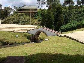
| Bridge of Boyaca | Puente de Boyacá | Rural Area (La Lajita) |
| Flower Pot Monument | Los Tiestos | K14-C16 |
| Mushroom Monument | Los Hongos | A Oriental |
| St. Martin's Church | Iglesia de San Martín | Libertador Neighborhood |
| Bullfighting arena | Plaza de Toros | K8-C13S |
Eastern Sector
| English Name | Spanish Name | Address |
|---|---|---|
| Botanical Garden | Jardín Botánico | BTS Highway (Autopista Circunvalar BTS) |
| St. Anthony's Church | Iglesia de San Antonio | San Antonio Neighborhood |
| Governorate Viaduct | Viaducto Paseo de La Gobernación | BTS-A.Olímpica |
| JNN Viaduct | Viaducto Jose Nepomuceno Niño | C24-Universitaria |
Downtown
| English name | Spanish name | Address |
|---|---|---|
| Las Nieves Church and Square | Iglesia y Plazoleta de las Nieves | K10-C22 |
| St. Ignatius' Church | Iglesia de San Ignacio | K10-C18 |
| *St. Barbara's Church | Iglesia de Santa Bárbara | K11-C17 |
| St. Dominic's Church | Iglesia de Santo Domingo | K11-C19 |
| St. Laureano's Church | Iglesia de San Laureano | K9-C15 |
| St. Lazarus Hill and Church | Loma e Iglesia de San Lázaro | San Lázaro Neighborhood |
| St. Claire Royal Convent | Convento de Santa Clara la Real | K11-C21 |
| St. Francis Church | Iglesia de San Francisco | K10-21A |
| Cathedral Basilica of St. James the Apostle in Tunja[14] | Catedral Basílica Metropolitana Santiago de Tunja | Bolivar Square |
| Meetinghouse of The Church of Jesus Christ of Latter-day Saints | La Iglesia de Jesucristo de los Santos de los Últimos Días | C12-K10 |
| Our Lady of Miracles Church | Iglesia de Nuestra Señora del Milagro (El Topo) | K15-C19 |
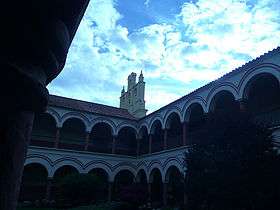
| St. Augustine Cloister | Claustro de San Agustín | K9-C23 |
| Cojines del Zaque | Cojines del Zaque | K4-C12 |
| Republic Forest | Bosque de la República | K11-C14 |
| Freedom Obelisk | Obelisco de la Libertad | K10-C14 |
| City Founder Gonzalo Suárez Rendón House and Museum | Casa Museo del Fundador | Bolívar Square |
| Juan de Castellanos' Palace and Museum | Casa Museo Juan de Castellanos | Bolívar Square |
| Don Juan de Vargas' Palace and Museum | Casa Museo Don Juan de Vargas | K9-C20 |
| Bolivar Square | Plaza de Bolívar | K9-C19 |
| Tower Palace (Governorate Palace of Boyacá) | Palacio de la Torre | Bolívar Square K10-C20 |
| Rojas Pinilla's House | Casa Cultural Rojas Pinilla | K11-C16 |
| Martyr's Wall Monument | Paredón de los Mártires | K9-C14 |
| La Pila del Mono's Fountain | La Pila del Mono | K9-C20 |
| Royal Palace (currently a shopping mall) | Plaza Real | K14-C20 |
| St. Thomas University Building | Edificio Universidad Santo Tomás | K12-C19 |
| Santander Park | Parque Santander | A Colón |
| Pinzón Park | Parque Pinzón | K8-C23 |
| Maldonado Park | Parque Maldonado | C10-C30 |
| La Esperanza Park | Parque La Esperanza | |
| Hoyo del Trigo Park | Parque Hoyo del Trigo | C22-K12 |
Northern Sector
| English name | Spanish name | Address |
|---|---|---|
| St. Agnes' Church | Iglesia de Santa Inés | C42-A Norte |
| Hunzahúa Well | Pozo de Hunzahúa | A Norte, UPTC |
| Indigenous Race Monument | Monumento a la raza indígena | La Glorieta |
| Campus of the Uptc and its natural reserve | Campus de la Uptc y su reserva natural | A Norte, UPTC |
| Museum of Natural History | Museo de Historia Natural | A Norte, UPTC |
| Museum of Anthropology | Museo de Antropología | A Norte, UPTC |
| The Independence Stadium | Estadio de La Independencia | A Olímpica |
| Olympic Village | Villa Olímpica | A Olímpica |
Festivals
Shopping
Downtown
Main places of interest are:
- El Cid
- El Virrey
- Teatro Boyacá
- Cinema Boyacá
Shopping malls
Unicentro is a shopping center that features a Jumbo and a Cinemark Theatres among many other stores.
Traditional markets
- Plaza de Mercado del Norte
- Plaza de Mercado del Sur
Education
Relative to its small size, Tunja has been important in providing education. A large part of its population are students between high school and university.
Tunja has a considerable amount of colleges, among these is the College of Boyacá, the first public school in the territories of Venezuela, Ecuador, Panama and Colombia, established when these countries were part of Gran Colombia. It was founded on 20 October 1822 by Vice President Francisco de Paula Santander. Among the most important schools are:
- Colegio de Boyacá
- Institucion Educativa San Jeronimo Emiliani
- Colegio Salesiano Maldonado
- Colegio INEM Carlos Arturo Torres
- Colegio de la Presentación
- Gimnasio Campestre del Norte.
- Colegio Municipal Silvino Rodríguez
- Normal Superior Santiago de Tunja.
- Escuela Normal Femenina "Leonor Álvarez Pinzón"
- Colegio Los Angeles
- Colegio Militar Juan José Rondón
- Colegio de Nuestra Señora del Rosario
- Colegio Gustavo Rojas Pinilla
- Colegio Andino
- Colegio American School Saint Frances
- Country Bilingual School
Universities
Tunja's major university, the Pedagogical and Technological University of Colombia (Uptc), was founded by General Gustavo Rojas Pinilla, and is one of the public universities in Colombia.
Other universities are:
- University of Boyaca
- Universidad Santo Tomás
- Escuela Superior de Administración Pública E.S.A.P.
- Universidad Nacional Abierta y a Distancia (UNAD)
- Fundacion Universitaria Juan de Castellanos
- Corporación Universitaria Remington (CUR-Cread Boyacá)
- Universidad Antonio Nariño
- Universidad Pontificia Bolivariana de Colombia
- Instituto Universitario de la Música y las Artes
Sports
The city has two professional football teams: Boyacá Chico and Patriotas F.C.. The teams play in the Colombian Professional Football A league. They play their games at La Independencia Stadium in the north of the city.
The stadium was rebuilt for the Copa Libertadores 2009, expanding capacity to 20,630 spectators and meeting FIFA specifications. The city organized the 2008 South American U-20 Futsal Cup in which Brazil was awarded as the championship. Colombia secured the fourth position in the tournament.
The city has a professional basketball team called Patriotas that plays in the Saludcoop Invitational Cup. This team plays its matches in the Municipality Colosseum that has a capacity of up to 5,000 spectators.
Born in Tunja
- Winner Anacona, professional cyclist
- Jair Bernal, former professional cyclist
- Iván Casas, professional cyclist
- Francisca Josefa de la Concepción, Criollo nun
- Pedro Antonio Herrera, professional cyclist
- José Ibáñez, former professional cyclist
- Diego Molano Vega, politician
- Gustavo Nieto Roa, film director
- Juan Carlos Pinzón, ambassador of Colombia to the United States
- Gustavo Rojas Pinilla, former president of Colombia
- Diego de Torres y Moyachoque, 16th century mestizo cacique of Turmequé
Sister cities
-
 Brazil: São Paulo
 -
 Ecuador: Guayaquil
 -
 Finland: Jyväskylä
 -
 Ireland: Dublin
 -
 Italy: Catania
 - Italy: Potenza[18] (2009)
-
 Mexico: Tapachula
 -
 Peru: Juliaca
 -
 Spain: Cádiz
 - Spain: Málaga[19] (2013)
- Spain: Sevilla
- Spain: Toledo[19] (2013)
-
 Colombia: Pamplona[19] (2012)
 - Colombia: Popayán[19] (2012)
- Colombia: San Juan de Pasto
- Colombia: Valledupar[20]
References
- 1 2 "2016". D.A.N.E. 2016. Retrieved 2011-11-30.
- ↑ (Spanish) El Turismo: fuerza económica de Boyacá
- ↑ "Los orígenes remotos de Tunja". Retrieved 31 August 2011.
- ↑ (Spanish) Biography Hunzahúa - Pueblos Originarios
- ↑ (Spanish) Biography Michuá - Pueblos Originarios
- ↑ (Spanish) Biography Quemuenchatocha - Pueblos Originarios
- ↑ (Spanish) Fundaciones de ciudades y poblaciones - Banco de la República
- ↑ Page officiel de la municipalité en espagnol
- ↑ International Centre of the Prevention of Crime, International report Crime prevention and Community safety: Trends and perspectives 2010
- ↑ Eduardo Posada Carb, journal El Tiempo, Colombia 2011
- ↑ Review The Safe cities in Colombia. December 2011 in Spanish
- ↑ 472 La Red Postal
- ↑ Tunja Google Maps
- ↑ Nombre oficial de la Catedral de Tunja
- ↑ "www.festivalinternacionaldelacultura.com". www.festivalinternacionaldelacultura.com. Retrieved 2010-04-17.
- ↑ "Semana Santa". www.tunja.gov. Retrieved 2010-04-17.
- ↑ "Aguinaldo Boyacense La Fiesta Grande de Boyacá para Colombia". www.tunja.gov. Retrieved 2010-04-17.
- ↑ Hermanamiento con la Región de Basilicata (Italia)
- 1 2 3 4 http://www.tunja.gov.co/?idcategoria=15278 Hermanamiento Semana Santa
- ↑ (Spanish) Valledupar
External links
| Wikimedia Commons has media related to Tunja. |
- (Spanish) News from Tunja at Excelsio
- (Spanish) News from Tunja at Mi Tunja.net
Treasures of Colombia | |||||||||||||||||||||||||||||||||||||||||||||||||||||
|---|---|---|---|---|---|---|---|---|---|---|---|---|---|---|---|---|---|---|---|---|---|---|---|---|---|---|---|---|---|---|---|---|---|---|---|---|---|---|---|---|---|---|---|---|---|---|---|---|---|---|---|---|---|
Archaeological sites · Colombia magia salvaje · National monuments · National parks · World Heritage sites | |||||||||||||||||||||||||||||||||||||||||||||||||||||
| |||||||||||||||||||||||||||||||||||||||||||||||||||||
| |||||||||||||||||||||||||||||||||||||||||||||||||||||
| |||||||||||||||||||||||||||||||||||||||||||||||||||||
Source: Wills, Fernando et al. 2001. Nuestro patrimonio - 100 tesoros de Colombia - Our heritage - 100 treasures of Colombia, 1-311. El Tiempo. | |||||||||||||||||||||||||||||||||||||||||||||||||||||