Touggourt
| Touggourt توقرت | |
|---|---|
| City | |
|
Monument de Citroen, Touggourt | |
 Location of Touggourt commune within Ouargla Province | |
 Touggourt Location of Touggourt within Algeria | |
| Coordinates: 33°06′N 6°04′E / 33.100°N 6.067°ECoordinates: 33°06′N 6°04′E / 33.100°N 6.067°E | |
| Country |
|
| Province | Ouargla |
| District | Touggourt |
| Area | |
| • Total | 216 km2 (83 sq mi) |
| Elevation | 62 m (203 ft) |
| Population (2008)[1] | |
| • Total | 143,270 |
| • Density | 660/km2 (1,700/sq mi) |
| Time zone | CET (UTC+01) |
| Postal code | 30200 |

Touggourt (Arabic: ﺗﻮﻗﺮت; Berber: ![]() , lit. the gateway or the gate) is a city and commune, former sultanate and capital of Touggourt District, in Ouargla Province, Algeria, built next to an oasis in the Sahara. As of the 2008 census, the commune had a population of 39,409 people,[1] up from 32,940 in 1998,[2] and an annual growth rate of 1.8%.[1] However, Touggourt's urban area includes the communes of Nezla, Tebesbest and Zaouia El Abidia, for a total population of 146,108.[1]
, lit. the gateway or the gate) is a city and commune, former sultanate and capital of Touggourt District, in Ouargla Province, Algeria, built next to an oasis in the Sahara. As of the 2008 census, the commune had a population of 39,409 people,[1] up from 32,940 in 1998,[2] and an annual growth rate of 1.8%.[1] However, Touggourt's urban area includes the communes of Nezla, Tebesbest and Zaouia El Abidia, for a total population of 146,108.[1]
Touggourt is notable for its date trees. It was formerly surrounded by a moat, which the French filled up. Bradt Travel Guides describe it as "largely a modern town of block architecture and as such is largely unattractive. The centre is quiet most of the day due to the heat but is more active at night when people take to the streets."[3]
History
In 1414 the Sultanate of Tuggert was founded in southern Algeria. The known Sultans (and one Sultana) were:
- Ali II
- Mabruk (Mubarak)
- Ali III
- Mustafa
- Sulayman III
- 1729 Ahmad II
- Muhammad I al-`Akhal
- Ahmad IV
- Farhat
- Ibrahim
- Abd al-Qadir I (1st time) + Ahmad V
- Khalid
- Abd al-Qadir I (2nd time)
- Umar bin Bu-Kumetin
- 1756 Muhammad II
- Umar II bin Muhammad
- Ahmad VI
- Abd al-Qadir II
- Farhat II
- 1792 Ibrahim II
- 1804 al-Khazan
- 1804 Muhammad III
- 1822 `Amar (`Amir) II
- 1830 Ibrahim III
- 1831 `Ali IV bin al-Kabir
- 1833 `Aisha (Aichouch)(female)
- 1840 `Abd ar-Rahman
- 1852 `Abd al-Qadir III
- 1852 - 1854 Sulayman IV
In 1854 the sultanate was abolished by the French colonial authorities in Algeria. Touggourt, as it is now spelled, becomes one of the initially six (1902), then four (1905) autonomous administrative districts constituting the Territoires du Sud (Southern Territories), which in 1957 are first joint, then reorganized into two regular French départements; Tuggert becomes part of Oasis (prefecture seat Quargla).
Geography
Touggourt lies on the western side of an extensive system of oases which supports palm plantations and other agriculture in an area 50 kilometres (31 mi) from north to south. Other towns around the oases are Sidi Slimane and Megarine to north, and Tamacine and Balidat Ameur to the south. The system is also associated with more oases further north in El Oued Province including the towns of Djamaa and El M'Ghair. Beyond the oases, the land is arid and barren, with extensive sand dunes both to the west and east of the city.
Climate
Touggourt has a hot desert climate (Köppen climate classification BWh), with long, extremely hot summers and short, warm winters. Averages high temperatures are consistently over 40 °C (104 °F) during 4 months (June, July, August and September) to reach a maximum of nearly 45 °C (113 °F) in July. Averages low temperatures in summer are also very high, and are above 26 °C (82.4 °F) and routinely above 29 °C (86 °F) during the hottest month. Average annual rainfall is around 55 mm (2,16 in) and summers are especially dry.
| Climate data for Touggourt | |||||||||||||
|---|---|---|---|---|---|---|---|---|---|---|---|---|---|
| Month | Jan | Feb | Mar | Apr | May | Jun | Jul | Aug | Sep | Oct | Nov | Dec | Year |
| Average high °C (°F) | 17.5 (63.5) |
19.8 (67.6) |
24.6 (76.3) |
29.7 (85.5) |
35.8 (96.4) |
41.3 (106.3) |
44.9 (112.8) |
44.2 (111.6) |
40.6 (105.1) |
33.8 (92.8) |
24.4 (75.9) |
18.1 (64.6) |
31.23 (88.2) |
| Average low °C (°F) | 5.5 (41.9) |
7.9 (46.2) |
11.1 (52) |
15.7 (60.3) |
19.4 (66.9) |
26.5 (79.7) |
27.2 (81) |
27.2 (81) |
24.8 (76.6) |
18.8 (65.8) |
12.5 (54.5) |
6.3 (43.3) |
16.91 (62.43) |
| Average precipitation mm (inches) | 7 (0.28) |
3 (0.12) |
10 (0.39) |
7 (0.28) |
2 (0.08) |
2 (0.08) |
1 (0.04) |
1 (0.04) |
2 (0.08) |
4 (0.16) |
7 (0.28) |
9 (0.35) |
55 (2.18) |
| Source #1: World Climate Guide[4] | |||||||||||||
| Source #2: Weatherbase (mean daily temperatures) [5] | |||||||||||||
Transportation
Touggourt lies at the junction of the N3 and N16 roads, 161 kilometres (100 mi) northeast of the provincial capital of Ouargla.[6] It is connected by railway to Biskra and is served by the Sidi Madhi Airport.[7]
The N3 highway connects to Megarine, Sidi Slimane, and Biskra to the north and Hassi Messaoud and Illizi to the south. The N16 connects to Taibet and El Oued to the east. Another road, the Route Messaad Tougourt, connects to Messaâd and Djelfa to the northwest. Local roads connect to nearby towns Megarine and Tamacine.
Localities
The commune is composed of nine localities:[8]
- Quartier de Mestaoua
- Sidi Abdessalem
- Baalouche
- Chateau d'eau
- Emir Abdelkader
- La gare
- Sidi Bouaziz
- Zone Industrielle
- Nouvelle Zone d'Activité
References
-
 This article incorporates text from a publication now in the public domain: Chisholm, Hugh, ed. (1911). "article name needed". Encyclopædia Britannica (11th ed.). Cambridge University Press.
- 1 2 3 4 "Population: Ouargla Wilaya" (PDF) (in French). Office National des Statistiques Algérie. Retrieved 24 February 2013.
- ↑ "Algeria Communes". Statoids. Retrieved 8 March 2013.
- ↑ Oakes, Johathan (17 June 2008). Algeria: the Bradt travel guide. Bradt Travel Guides. p. 199. ISBN 978-1-84162-232-3. Retrieved 28 January 2013.
- ↑ "Touggourt Climate Guide, Algeria". World Climate Guide. Retrieved 26 February 2013.
- ↑ "Touggourt, Algeria Travel Weather Averages". Weatherbase. Retrieved 26 February 2013.
- ↑ Google (28 January 2013). "Touggourt" (Map). Google Maps. Google. Retrieved 28 January 2013.
- ↑ "Touggourt Sidi Madhi Airport". OurAirports. Retrieved 26 February 2013.
- ↑ "Décret n° 84-365, fixant la composition, la consistance et les limites territoriale des communes. Wilaya d'El Oued" (PDF) (in French). Journal officiel de la République Algérienne,. 19 December 1984. p. 1551. Archived from the original (PDF) on 2 March 2013 or before. Retrieved 2 March 2013. Check date values in:
|archive-date=(help)
Sources and External links
 |
Djelfa Messaâd |
Biskra El M'Ghair (El Oued) Djamaa (El Oued) Sidi Slimane Megarine |
Tebesbest | |
| Ghardaïa | |
El Oued Taibet | ||
| ||||
| | ||||
| El Hadjira Ouargla |
Nezla Tamacine Balidat Ameur Hassi Messaoud |
Grand Erg Oriental |
Capital: Ouargla | ||
| Ouargla District | 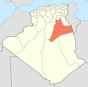 | |
| El Borma District | ||
| El Hadjira District | ||
| Hassi Messaoud District | ||
| Mégarine District | ||
| N'Goussa District | ||
| Sidi Khouïled District | ||
| Taïbet District | ||
| Témacine District | ||
| Touggourt District | ||