Tsukui, Kanagawa
| Tsukui 津久井町 | |
|---|---|
| Former municipality | |
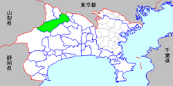 Location of Tsukui in Kanagawa Prefecture | |
| Coordinates: 35°35′02″N 139°15′30″E / 35.5838°N 139.2584°ECoordinates: 35°35′02″N 139°15′30″E / 35.5838°N 139.2584°E | |
| Country | Japan |
| Region | Kantō |
| Prefecture | Kanagawa Prefecture |
| District | Tsukui |
| Merged |
March 11, 2007 (now part of Sagamihara) |
| Area | |
| • Total | 122.04 km2 (47.12 sq mi) |
| Population (March 1, 2006) | |
| • Total | 28,551 |
| • Density | 233.9/km2 (606/sq mi) |
| Symbols | |
| • Tree | Maple |
| • Flower | Rhododendron |
| • Bird | Japanese bush-warbler |
| Time zone | Japan Standard Time (UTC+9) |
Tsukui (津久井町 Tsukui-machi) was a town located in Tsukui District, Kanagawa Prefecture, Japan.
As of March 1, 2006, final population data before the amalgamation, the town had an estimated population of 28,551 and a density of 233.9 persons per km2. The total area was 122.04 km2.
On March 20, 2006, Tsukui, along with the town of Sagamiko (also from Tsukui District), was merged into the expanded city of Sagamihara, and thus no longer exists as an independent municipality. It is now part of Midori-ku, Sagamihara.
This article is issued from Wikipedia - version of the 12/16/2015. The text is available under the Creative Commons Attribution/Share Alike but additional terms may apply for the media files.