Trudering-Riem
| Trudering-Riem | |
|---|---|
| borough of Munich | |
|
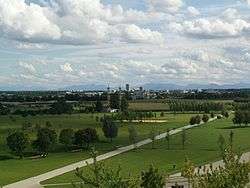
Riemer Park | |
 Trudering-Riem | |
Location of Trudering-Riem within Munich _-_Trudering_-_Riem.png) | |
| Coordinates: 48°07′00″N 11°39′30″E / 48.11667°N 11.65833°ECoordinates: 48°07′00″N 11°39′30″E / 48.11667°N 11.65833°E | |
| Country | Germany |
| State | Bavaria |
| Admin. region | Upper Bavaria |
| District | urban district |
| City | Munich |
| Founded | 772 |
| Government | |
| • Lord Mayor | Dieter Reiter (SPD) |
| Area | |
| • Total | 22,4 km2 (86 sq mi) |
| Population (2013-12-31) | |
| • Total | 67,009 |
| • Density | 300/km2 (770/sq mi) |
| Time zone | CET/CEST (UTC+1/+2) |
| Postal codes | 81735, 81825, 81827, 81829 |
| Dialling codes | 089 |
| Vehicle registration | M |
| Website | http://www.muenchen.de/stadtteile/trudering.html |
Trudering-Riem (Central Bavarian: Trudaring-Ream) is the 15th borough of Munich, Bavaria, consisting of the districts Trudering and Riem.
Location
In the west the borough borders the boroughs Berg am Laim and Bogenhausen, in the south Ramersdorf-Perlach, in the north Johanneskirchen and in the east the municipalities Aschheim, Feldkirchen, Haar and Putzbrunn (belonging to the Munich district))
There are the following subdistricts:
- Am Moosfeld
- Gartenstadt Trudering
- Kirchtrudering
- Messestadt Riem
- Neutrudering
- Riem
- Straßtrudering
- Waldtrudering
The old village center of Riem is situated around the church of St. Martin that lies in the street Martin-Empl-Ring. The old village center of Kirchtrudering is situated around the church St. Peter and Paul in the Kirchtruderinger Straße and the one of Straßtrudering at the junction of Truderinger Straße and Bajuwarenstraße.
Literature
- Willibald Karl (Hrsg.), Karl Bachmaier u. a.: Trudering, Waldtrudering, Riem. Münchens ferner Osten. Volk Verlag, München 2003, ISBN 3-937200-06-1.
- Stadtbezirk Trudering-Riem – Informationen für Bürger und Gäste. WEKA-Verlag, Mering 2004, OCLC 76558831. (online im Webarchiv, PDF; 1,5 MB)
- Brückl, Josef: 1200 Jahre Trudering. Festausgabe zur zwölfhundertjährigen Wiederkehr der ersten urkundlichen Erwähnung. Mit handschriftlicher Widmung vom Autor. Emil Biehl & Söhne (Gesamtherstellung), München 1972.
Statistics

(As of each 31 December, residents whose main residence)
| year | residents | area (ha) | res./ha | source and further details[1] |
|---|---|---|---|---|
| 2000 | 42.996 | 2245,39 | 19 | Statistisches Taschenbuch München 2001 (PDF) |
| 2001 | 45.403 | 2245,39 | 20 | Statistisches Taschenbuch München 2002 (PDF) |
External links
- www.muenchen.de - Trudering (German)
- www.muenchen.de - Riem (German)
- History (German)
- Abendzeitung (German)
References
- ↑ Archiv Stadtteilinformationen. Landeshauptstadt München. Retrieved 30 December 2014.