Troup County, Georgia
| Troup County, Georgia | |
|---|---|
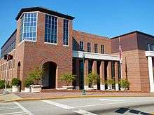 Troup County Courthouse and Government Center in LaGrange | |
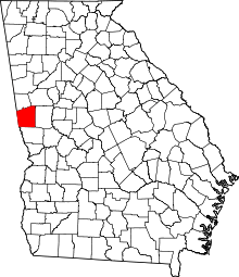 Location in the U.S. state of Georgia | |
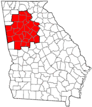
 Georgia's location in the U.S. | |
| Founded | June 9, 1826 |
| Named for | George Troup |
| Seat | LaGrange |
| Largest city | LaGrange |
| Area | |
| • Total | 446 sq mi (1,155 km2) |
| • Land | 414 sq mi (1,072 km2) |
| • Water | 32 sq mi (83 km2), 7.2% |
| Population (est.) | |
| • (2015) | 69,763 |
| • Density | 162/sq mi (63/km²) |
| Congressional district | 3rd |
| Time zone | Eastern: UTC-5/-4 |
| Website |
www |
Troup County is a county located in the west central portion of the U.S. state of Georgia. As of the 2010 census, the population was 67,044.[1] The county seat is LaGrange.[2]
Troup County comprises the LaGrange, GA Micropolitan Statistical Area, which is also included in the Atlanta-Athens-Clarke County-Sandy Springs, GA Combined Statistical Area.
History
The land for Lee, Muscogee, Troup, Coweta, and Carroll counties was ceded by the Creek people in the 1825 Treaty of Indian Springs. The counties' boundaries were created by the Georgia General Assembly on June 9, 1826, but they were not named until December 14, 1826.
The county is named for George Troup,[3] thirty-fourth governor of Georgia, U.S. representative, and senator.
The official historian of Troup County is noted author Forrest Clark Johnson, III.
Geography
According to the U.S. Census Bureau, the county has a total area of 446 square miles (1,160 km2), of which 414 square miles (1,070 km2) is land and 32 square miles (83 km2) (7.2%) is water.[4]
The entirety of Troup County is located in the Middle Chattahoochee River-Lake Harding sub-basin of the ACF River Basin (Apalachicola-Chattahoochee-Flint River Basin).[5]
Major highways
-
 Interstate 85
 -
.svg.png) Interstate 185
Interstate 185 -
 U.S. Route 27
 -
 U.S. Route 29
 -
 State Route 1
 -
 State Route 14
 -
 State Route 14 Connector
 -
 State Route 14 Spur
 -
 State Route 18
 -
 State Route 54
 -
 State Route 100
 -
 State Route 103
 -
 State Route 109
 -
 State Route 219
 -
 State Route 403 (unsigned designation for I-85)
 -
 State Route 411 (unsigned designation for I-185)
Adjacent counties
- Coweta County (northeast)
- Meriwether County (east)
- Harris County (south)
- Chambers County, Alabama (southwest/CST Border except for Lanett and Valley as they are part of the Columbus Metropolitan Area)
- Randolph County, Alabama (northwest/CST Border)
- Heard County (north)
Demographics
| Historical population | |||
|---|---|---|---|
| Census | Pop. | %± | |
| 1830 | 5,799 | — | |
| 1840 | 15,733 | 171.3% | |
| 1850 | 16,879 | 7.3% | |
| 1860 | 16,262 | −3.7% | |
| 1870 | 17,632 | 8.4% | |
| 1880 | 20,565 | 16.6% | |
| 1890 | 20,723 | 0.8% | |
| 1900 | 24,002 | 15.8% | |
| 1910 | 26,228 | 9.3% | |
| 1920 | 36,097 | 37.6% | |
| 1930 | 36,752 | 1.8% | |
| 1940 | 43,879 | 19.4% | |
| 1950 | 49,841 | 13.6% | |
| 1960 | 47,189 | −5.3% | |
| 1970 | 44,466 | −5.8% | |
| 1980 | 50,003 | 12.5% | |
| 1990 | 55,536 | 11.1% | |
| 2000 | 58,779 | 5.8% | |
| 2010 | 67,044 | 14.1% | |
| Est. 2015 | 69,763 | [6] | 4.1% |
| U.S. Decennial Census[7] 1790-1960[8] 1900-1990[9] 1990-2000[10] 2010-2013[1] | |||
2000 census
As of the census[11] of 2000, there were 58,779 people, 21,920 households, and 15,607 families residing in the county. The population density was 142 people per square mile (55/km²). There were 23,824 housing units at an average density of 58 per square mile (22/km²). The racial makeup of the county was 65.80% White, 31.87% Black or African American, 0.16% Native American, 0.58% Asian, 0.06% Pacific Islander, 0.75% from other races, and 0.78% from two or more races. 1.71% of the population were Hispanic or Latino of any race.
There were 21,920 households out of which 34.60% had children under the age of 18 living with them, 49.10% were married couples living together, 17.90% had a female householder with no husband present, and 28.80% were non-families. 24.90% of all households were made up of individuals and 10.20% had someone living alone who was 65 years of age or older. The average household size was 2.61 and the average family size was 3.12.
In the county the population was spread out with 27.90% under the age of 18, 9.20% from 18 to 24, 28.40% from 25 to 44, 21.90% from 45 to 64, and 12.60% who were 65 years of age or older. The median age was 35 years. For every 100 females there were 91.00 males. For every 100 females age 18 and over, there were 86.70 males.
The median income for a household in the county was $35,469, and the median income for a family was $41,891. Males had a median income of $31,863 versus $22,393 for females. The per capita income for the county was $17,626. About 12.20% of families and 14.80% of the population were below the poverty line, including 20.70% of those under age 18 and 14.00% of those age 65 or over.
2010 census
As of the 2010 United States Census, there were 67,044 people, 24,828 households, and 17,489 families residing in the county.[12] The population density was 161.9 inhabitants per square mile (62.5/km2). There were 28,046 housing units at an average density of 67.7 per square mile (26.1/km2).[13] The racial makeup of the county was 61.5% white, 33.4% black or African American, 1.6% Asian, 0.3% American Indian, 0.1% Pacific islander, 1.7% from other races, and 1.5% from two or more races. Those of Hispanic or Latino origin made up 3.2% of the population.[12] In terms of ancestry, 12.3% were English, 12.1% were American, 11.4% were Irish, and 7.3% were German.[14]
Of the 24,828 households, 37.9% had children under the age of 18 living with them, 45.0% were married couples living together, 20.3% had a female householder with no husband present, 29.6% were non-families, and 25.1% of all households were made up of individuals. The average household size was 2.62 and the average family size was 3.12. The median age was 36.3 years.[12]
The median income for a household in the county was $41,770 and the median income for a family was $50,625. Males had a median income of $39,960 versus $28,218 for females. The per capita income for the county was $19,699. About 15.5% of families and 19.8% of the population were below the poverty line, including 30.1% of those under age 18 and 14.2% of those age 65 or over.[15]
Communities
- Harrisonville
- Hogansville
- LaGrange
- Mountville
- West Point
- Gray Hill
See also
References
- 1 2 "State & County QuickFacts". United States Census Bureau. Retrieved June 26, 2014.
- ↑ "Find a County". National Association of Counties. Retrieved 2011-06-07.
- ↑ bioguide.congress.gov/scripts/biodisplay.pl
- ↑ "US Gazetteer files: 2010, 2000, and 1990". United States Census Bureau. 2011-02-12. Retrieved 2011-04-23.
- ↑ "Georgia Soil and Water Conservation Commission Interactive Mapping Experience". Georgia Soil and Water Conservation Commission. Retrieved 2015-11-20.
- ↑ "County Totals Dataset: Population, Population Change and Estimated Components of Population Change: April 1, 2010 to July 1, 2015". Retrieved July 2, 2016.
- ↑ "U.S. Decennial Census". United States Census Bureau. Retrieved June 26, 2014.
- ↑ "Historical Census Browser". University of Virginia Library. Retrieved June 26, 2014.
- ↑ "Population of Counties by Decennial Census: 1900 to 1990". United States Census Bureau. Retrieved June 26, 2014.
- ↑ "Census 2000 PHC-T-4. Ranking Tables for Counties: 1990 and 2000" (PDF). United States Census Bureau. Retrieved June 26, 2014.
- ↑ "American FactFinder". United States Census Bureau. Retrieved 2008-01-31.
- 1 2 3 "DP-1 Profile of General Population and Housing Characteristics: 2010 Demographic Profile Data". United States Census Bureau. Retrieved 2015-12-30.
- ↑ "Population, Housing Units, Area, and Density: 2010 - County". United States Census Bureau. Retrieved 2015-12-30.
- ↑ "DP02 SELECTED SOCIAL CHARACTERISTICS IN THE UNITED STATES – 2006-2010 American Community Survey 5-Year Estimates". United States Census Bureau. Retrieved 2015-12-30.
- ↑ "DP03 SELECTED ECONOMIC CHARACTERISTICS – 2006-2010 American Community Survey 5-Year Estimates". United States Census Bureau. Retrieved 2015-12-30.
 |
Randolph County, Alabama | Heard County | Coweta County | |
| |
Meriwether County | |||
| ||||
| | ||||
| Chambers County, Alabama | Harris County |
Municipalities and communities of Troup County, Georgia, United States | ||
|---|---|---|
| Cities | | |
| Footnotes | ‡This populated place also has portions in an adjacent county or counties | |
|  | |||||||
|
| ||||||||
| ||||||||
Template:Georgia
Coordinates: 33°02′N 85°02′W / 33.03°N 85.03°W