Tropical cyclone forecasting
| Part of a series on |
| Tropical cyclones |
|---|
|
Formation and naming |
|
Climatology and tracking |
|
Tropical cyclone naming Tropical cyclone naming History of tropical cyclone naming List of historic tropical cyclone names List of retired Atlantic hurricane names List of retired Pacific hurricane names List of retired Pacific typhoon names List of retired Philippine typhoon names List of retired Australian cyclone names List of retired South Pacific tropical cyclone names |
|
Outline of tropical cyclones |
Tropical cyclone forecasting is the science of forecasting where a tropical cyclone's center, and its effects, are expected to be at some point in the future. There are several elements to tropical cyclone forecasting: track forecasting, intensity forecasting, rainfall forecasting, storm surge, and tornado forecasting. While skill is increasing in regard to track forecasting, intensity forecasting skill remains nearly unchanged over the past several years.
History
The methods through which tropical cyclones are forecast have changed with the passage of time. The first known forecasts in the Western Hemisphere were made by Lt. Col. William Reed of the Corps of Royal Engineers at Barbados in 1847. Reed mostly utilized barometric pressure measurements as the basis of his forecasts. Benito Vines introduced a forecast and warning system based on cloud cover changes in Havana during the 1870s. Before the early 1900s, though, most forecasts were done by direct observations at weather stations, which were then relayed to forecast centers via telegraph. It wasn’t until the advent of radio in the early twentieth century that observations from ships at sea were available to forecasters. The 1930s saw the usage of radiosondes in tropical cyclone forecasting. The next decade saw the advent of aircraft-based reconnaissance by the military, starting with the first dedicated flight into a hurricane in 1943, and the establishment of the Hurricane Hunters in 1944. In the 1950s, coastal weather radars began to be used in the United States, and research reconnaissance flights by the precursor of the Hurricane Research Division began in 1954.[1]
The launch of the first weather satellite, TIROS-I, in 1960, introduced new forecasting techniques that remain important to tropical cyclone forecasting to the present. In the 1970s, buoys were introduced to improve the resolution of surface measurements, which until that point, were not available at all over sea surfaces.[1]
Track
The large-scale synoptic flow determines 70 to 90 percent of a tropical cyclone's motion. The deep-layer mean flow is considered to be the best tool in determining track direction and speed. If storms are significantly sheared, use of a lower-level wind is a better predictor. Knowledge of the beta effect can be used to steer a tropical cyclone, since it leads to a more northwest heading for tropical cyclones in the Northern Hemisphere. It is also best to smooth out short term wobbles of the storm center in order to determine a more accurate trajectory.[2]
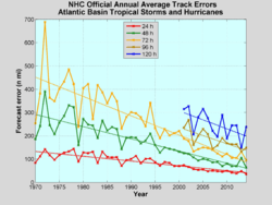
Because of the forces that affect tropical cyclone tracks, accurate track predictions depend on determining the position and strength of high- and low-pressure areas, and predicting how those areas will change during the life of a tropical system. Combining forecast models with increased understanding of the forces that act on tropical cyclones, and a wealth of data from Earth-orbiting satellites and other sensors, scientists have increased the accuracy of track forecasts over recent decades.[3] An accurate track forecast is important, because if the track forecast is incorrect, forecasts for intensity, rainfall, storm surge, and tornado threat will also be incorrect.
1-2-3 rule
The 1-2-3 rule (mariner's 1-2-3 rule or danger area) is a guideline commonly taught to mariners for severe storm (specifically hurricane and tropical storm) tracking and prediction. It refers to the rounded long-term NHC/TPC forecast errors of 100-200-300 nautical miles at 24-48-72 hours, respectively. These numbers were close to the 10-year average for the 1982-1991 time frame.[4] However, these errors have decreased to near 50-100-150 as NHC forecasters become more accurate. The "danger area" to be avoided is constructed by expanding the forecast path by a radius equal to the respective hundreds of miles plus the forecast wind radii (size of the storm at those hours).[5]
Intensity
Forecasters say they are less skillful at predicting the intensity of tropical cyclones than cyclone track.[6] They attribute the lack of improvement in intensity forecasting to the complexity of tropical systems and an incomplete understanding of factors that affect their development.
An accurate track forecast is essential to creating accurate intensity forecasts, particularly in an area with large islands such as the western north Pacific and the Caribbean Sea, as proximity to land is an inhibiting factor to developing tropical cyclones. A strong hurricane/typhoon/cyclone can weaken if an outer eye wall forms (typically around 80-160 kilometers (50–100 miles) from the center of the storm), choking off the convection within the inner eye wall. Such weakening is called an eyewall replacement cycle, and is usually temporary.[7]
Maximum potential intensity
Dr. Kerry Emanuel created a mathematical model around 1988, called the maximum potential intensity or MPI, to compute the upper limit of tropical cyclone intensity based on sea surface temperature and atmospheric profiles from the latest global model runs. Maps created from this equation show values of the maximum achievable intensity due to the thermodynamics of the atmosphere at the time of the last model run (either 0000 or 1200 UTC). However, MPI does not take vertical wind shear into account.[8] MPI is computed using the following formula:

Where is the maximum potential velocity in meters per second; is the sea surface temperature underneath the center of the tropical cyclone, is a reference temperature (30˚C) and , and are curve-fit constants. When , , and , the graph generated by this function corresponds to the 99th percentile of empirical tropical cyclone intensity data.[9]


Rainfall

Tropical cyclone rainfall forecasting is important, since between 1970–2004, inland flooding from tropical cyclones caused a majority of the fatalities from tropical cyclones in the United States.[10][11] While flooding is common to tropical cyclones near a landmass, there are a few factors which lead to excessive rainfall from tropical cyclones. Slow motion, as was seen during Hurricane Danny and Hurricane Wilma, can lead to high amounts. The presence of topography near the coast, as is the case across much of Mexico, Haiti, the Dominican Republic, much of Central America, Madagascar, Réunion, China, and Japan acts to magnify amounts due to upslope flow into the mountains. Strong upper level forcing from a trough moving through the Westerlies, as was the case during Hurricane Floyd, can lead to high amounts even from systems moving at an average forward motion. A combination of two of these factors could be especially crippling, as was seen during Hurricane Mitch in Central America.[12] Therefore, an accurate track forecast is essential in order to produce an accurate tropical cyclone rainfall forecast.[13]
Storm surge
The main storm surge forecast model in the Atlantic basin is SLOSH, which stands for Sea, Lake, Overland, Surge from Hurricanes.[14] It uses the size of a storm, its intensity, its forward motion, and the topography of the coastal plain to estimate the depth of a storm surge at any individual grid point across the United States. An accurate forecast track is required in order to produce accurate storm surge forecasts. However, if the landfall point is uncertain, a maximum envelope of water (MEOW) map can be generated based on the direction of approach. If the forecast track itself is also uncertain, a maximum of maximums (MoM) map can be generated which will show the worst possible scenario for a hurricane of a specific strength.[15]
Tornado
The location of most tropical cyclone-related tornadoes is their northeast quadrant in the Northern Hemisphere and southeast quadrant in the Southern Hemisphere.[16] Like most of the other forecasts for tropical cyclone effects, an accurate track forecast is required in order to produce an accurate tornado threat forecast.
Seasonal forecast
By looking at annual variations in various climate parameters, forecasters can make predictions about the overall number and intensity of tropical cyclones that will occur in a given season. For example, when constructing its seasonal outlooks, the Climate Prediction Center in the United States considers the effects of the El Niño-Southern Oscillation, 25-40 year tropical cycle, wind shear over the oceans, and ocean surface temperature.[17]
See also
References
- 1 2 Robert C. Sheets (June 1990). "The National Hurricane Center—Past, Present and Future" (PDF). Weather and Forecasting. 5 (2): 185. Bibcode:1990WtFor...5..185S. doi:10.1175/1520-0434(1990)005<0185:TNHCPA>2.0.CO;2. Retrieved 2007-12-07.
- ↑ U. S. Navy. SECTION 1. INFLUENCES ON TROPICAL CYCLONE MOTION. Retrieved on 2007-04-10.
- ↑ National Hurricane Center (2013-04-03). Annual average model track errors for Atlantic basin tropical cyclones for the period 1994-2005, for a homogeneous selection of "early" models. Retrieved on 2006-11-30.
- ↑ L. T. William Schulz and Patrick Dixon (Fall 1994). "Hurricane Emily Threatens the Atlantic Fleet: Tale of Two Sorties". Mariners Weather Log. 38 (4): 4.
- ↑ Central Pacific Hurricane Center. Hurricane Awareness Week 2005. Retrieved on 2007-12-24.
- ↑ National Hurricane Center. Annual average official track errors for Atlantic basin tropical cyclones for the period 1989-2005, with least-squares trend lines superimposed. Retrieved on 2006-11-30.
- ↑ Atlantic Oceanographic and Meteorological Laboratory (2006). Frequently Asked Questions: What are "concentric eyewall cycles" (or "eyewall replacement cycles") and why do they cause a hurricane's maximum winds to weaken? Hurricane Research Division. Retrieved on 2006-12-14.
- ↑ Kerry A. Emanuel (1997-08-07). Maximum Intensity Estimation. Retrieved on 2006-10-20.
- ↑ DeMaria, Mark; John Kaplan (September 1994). "Sea Surface Temperature and the Maximum Intensity of Atlantic Tropical Cyclones". Journal of Climate. American Meteorological Society. 7 (9): 1324–1334. Bibcode:1994JCli....7.1324D. doi:10.1175/1520-0442(1994)007<1324:SSTATM>2.0.CO;2. ISSN 1520-0442. Retrieved 2008-07-30.
- ↑ FEMA. Hurricanes. Retrieved on 2013-05-03.
- ↑ Ed Rappaport. Inland Flooding. Retrieved on 2006-06-24.
- ↑ "Are You Ready?". Federal Emergency Management Agency. 2006-04-05. Retrieved 2006-06-24.
- ↑ William M. Frank. Fifth International Workshop On Tropical Cyclones: Topic 2 Tropical Cyclone Landfall Processes. Retrieved on 2007-04-17.
- ↑ National Hurricane Center (2011-10-03). "Sea, Lake, and Overland Surges from Hurricanes (SLOSH)". National Oceanic and Atmospheric Administration. Retrieved 2013-05-03.
- ↑ PC Weather Products. Slosh Data... what is it. Retrieved on 2007-04-15.
- ↑ Roger Edwards (1998-01-11 to 18). Storm Prediction Center Forecast Support For Landfalling Tropical Cyclones. Retrieved on 2013-05-03.
- ↑ Ira Flatow, Science Friday (2009-08-21). What's on the Horizon for Hurricane Season? National Public Radio. Retrieved on 2013-05-03.