Tropical Storm Matmo (2008)
| Severe tropical storm (JMA scale) | |
|---|---|
| Tropical storm (Saffir–Simpson scale) | |
 Tropical Storm Matmo | |
| Formed | May 14, 2008 |
| Dissipated | May 18, 2008 |
| (Extratropical after May 17) | |
| Highest winds |
10-minute sustained: 95 km/h (60 mph) 1-minute sustained: 75 km/h (45 mph) |
| Lowest pressure | 992 hPa (mbar); 29.29 inHg |
| Fatalities | None reported |
| Damage | None |
| Areas affected | Philippines, Japan |
| Part of the 2008 Pacific typhoon season | |
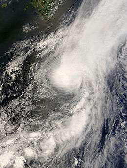
Severe Tropical Storm Matmo, known in the Philippines as Tropical Storm Dindo, formed to the east of Manila in the Philippines as a tropical disturbance on May 13, 2008. Early the next day, the Joint Typhoon Warning Center (JTWC) issued a Tropical Cyclone Formation Alert on the developing system while later that day the Japan Meteorological Agency (JMA) classified the disturbance as a weak tropical depression and started to issue advisories on it. The JTWC then designated the depression as Tropical Depression 04W while the JMA started to issue full advisories on the storm. On May 15, the tropical depression intensified into a tropical storm and was named Matmo by RSMC Tokyo. Later that day the Philippine Atmospheric, Geophysical and Astronomical Services Administration issued their first advisory on Matmo and assigned the local name Dindo. The JTWC upgraded the system to a tropical storm later that day. It then intensified into a severe tropical storm the next day while the JTWC issued their final advisory on Matmo as they thought the storm had become extratropical. However, the JMA kept issuing advisories on Matmo, until the storm dissipated the next day. There was no impact reported from Tropical Storm Matmo.
Meteorological history
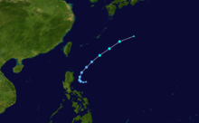
Late on May 13, 2008, a tropical disturbance formed about 550 km (340 mi), to the east of Manila in the Philippines.[1] The disturbance was located in an area of low vertical wind shear and had a low-level circulation center which had started to consolidate.[1] The Joint Typhoon Warning Center (JTWC) then issued a Tropical Cyclone Formation Alert on the disturbance early the next day, as deep convection was building near to the low pressure area.[2] Later that day both the JTWC and the Japan Meteorological Agency (JMA) upgraded the disturbance to a tropical depression, with the JTWC designating it as Tropical Depression 04W. This was because the system had become more consolidated and had a good outflow.[3][4][5]
Early on May 15, as the storm was moving towards the northwest, the JMA upgraded the tropical depression to a Tropical Storm and named it Matmo.[3] The Philippine Atmospheric, Geophysical and Astronomical Services Administration (PAGASA) then designated the storm as Tropical Depression Dindo.[6] Later that day Matmo rapidly tracked towards the northeastern boundary of PAGASA's area of responsibility as it had started to interact with a mid-latitude trough.[7] The JTWC then reported that the cyclone had intensified into a tropical storm and had reached its peak intensity with winds of 75 km/h (45 mph).[8] Early on May 16, both PAGASA and the JTWC issued their final advisories on the storm as it approached the edge of PAGASA's Area of responsibility, with the JTWC reporting that Matmo was now extratropical.[9][10] However, the JMA continued to issue advisories on the storm at this time and reported that it had reached ten-minute peak wind speeds of 95 km/h (60 mph), which made Matmo a severe tropical storm.[3] Though, within their next advisory, the JMA downgraded Matmo to a tropical storm and reported that it had weakened into a tropical depression early the next day before dissipating later that day.[3][11]
Preparations, impact and naming
In preparation for Tropical Storm Matmo, the Japan Meteorological Agency issued warnings for the, Naha, Moji and Yokohama areas of Japan.[12] However, there was no impact reported from either Japan or the Philippines.[13][14]
The name Matmo was submitted to the ESCAP/WMO Typhoon Committee, by the United States of America, for use from January 1, 2004 and means heavy rain in the Chamorro language.[15] This came after the name Chataan was retired, following the 2002 Pacific typhoon season.[15] The Philippine Atmospheric, Geophysical and Astronomical Services Administration (PAGASA) also assigned the local name of Dindo to Matmo, which was last assigned by PAGASA, in the 2004 Pacific typhoon season.[16]
See also
References
- 1 2 "Significant Tropical Weather advisory for the Western and Southern Pacific oceans". Joint Typhoon Warning Center. 2008-05-13. Retrieved 2009-02-20.
- ↑ "Tropical Cyclone Formation Alert 14-05-2008". Joint Typhoon Warning Center. 2008-05-14. Archived from the original on May 14, 2008. Retrieved 2009-02-20.
- 1 2 3 4 Japan Meteorological Agency (2008-06-16). "RSMC Tropical Cyclone Best Track". Archived from the original on June 16, 2008. Retrieved 2009-02-20.
- ↑ "Tropical Cyclone Warning 14-05-2008 06z". Joint Typhoon Warning Center. 2008-05-14. Archived from the original on May 14, 2008. Retrieved 2009-02-20.
- ↑ "Prognostic Reasoning for Tropical Depression 04W 14-05-2008 12z". Joint Typhoon Warning Center. 2008-05-14. Retrieved 2009-02-20.
- ↑ "PAGASA Advisory 15-05-2008 15z". Philippine Atmospheric, Geophysical and Astronomical Services Administration. 2008-05-15. Archived from the original on May 15, 2008. Retrieved 2009-02-20.
- ↑ "Prognostic Reasoning for Tropical Storm 04W (Matmo) 16-05-2008 03z". Joint Typhoon Warning Center. 2008-05-16. Retrieved 2009-02-20.
- ↑ "Tropical Cyclone Warning 15-05-2008 21z". Joint Typhoon Warning Center. 2008-05-15. Retrieved 2009-02-20.
- ↑ "PAGASA Advisory 16-05-08 03z". Philippine Atmospheric, Geophysical and Astronomical Services Administration. 2008-05-16. Archived from the original on May 15, 2008. Retrieved 2009-02-20.
- ↑ "Tropical Cyclone Warning 16-05-2008 06z". Joint Typhoon Warning Center. 2008-05-16. Retrieved 2009-02-20.
- ↑ "RSMC Tokyo Tropical Cyclone Summary 2008". Japan Meteorological Agency. 2009-02-20. Retrieved 2009-02-20.
- ↑ "JMA WWJP25 Tropical Cyclone Warning 14-05-2008 12z". Japan Meteorological Agency. 2008-05-14. Retrieved 2009-02-20.
- ↑ Gary Padgett (2009-02-20). "Gary Padgett's Monthly Tropical Cyclone Summary". Australian Severe Weather. Retrieved 2009-02-20.
- ↑ Japan Meteorological Agency (2008-12-23). "Japan Country report for the 41st Typhoon Committee" (PDF). World Meteorological Organisation. Retrieved 2009-02-20.
- 1 2 ESCAP/WMO Typhoon Committee (2009-04-02). "Typhoon Committee Operational Manual" (PDF). World Meteorological Organisation. Retrieved 2009-02-20.
- ↑ David Michael V. Padua (2009-02-22). "2004 Pacific Typhoon Season". Typhoon 2000. Retrieved 2009-02-22.
External links
| Wikimedia Commons has media related to Tropical Storm Matmo (2008). |
- JMA General Information of Severe Tropical Storm Matmo (0803) from Digital Typhoon
- JMA Best Track Data of Severe Tropical Storm Matmo (0803) (Japanese)
- JMA Best Track Data (Graphics) of Severe Tropical Storm Matmo (0803)
- JMA Best Track Data (Text)
- JTWC Best Track Data of Tropical Storm 04W (Matmo)
- 04W.MATMO from the U.S. Naval Research Laboratory
Tropical cyclones of the 2008 Pacific typhoon season | ||||||||||||||||||||||||||||||||||||||||||||||||||||||||||||||||||||||||||||||||||||||||||||||||||||||||||||||||||||||||||
|---|---|---|---|---|---|---|---|---|---|---|---|---|---|---|---|---|---|---|---|---|---|---|---|---|---|---|---|---|---|---|---|---|---|---|---|---|---|---|---|---|---|---|---|---|---|---|---|---|---|---|---|---|---|---|---|---|---|---|---|---|---|---|---|---|---|---|---|---|---|---|---|---|---|---|---|---|---|---|---|---|---|---|---|---|---|---|---|---|---|---|---|---|---|---|---|---|---|---|---|---|---|---|---|---|---|---|---|---|---|---|---|---|---|---|---|---|---|---|---|---|---|---|
 |
| |||||||||||||||||||||||||||||||||||||||||||||||||||||||||||||||||||||||||||||||||||||||||||||||||||||||||||||||||||||||||
| ||||||||||||||||||||||||||||||||||||||||||||||||||||||||||||||||||||||||||||||||||||||||||||||||||||||||||||||||||||||||||