Tropical Storm Arlene (2005)
| Tropical storm (SSHWS/NWS) | |
 Tropical Storm Arlene on June 11, 2005, at 1645 UTC | |
| Formed | June 8, 2005 |
|---|---|
| Dissipated | June 16, 2005 |
| (Extratropical after June 13, 2005) | |
| Highest winds |
1-minute sustained: 70 mph (110 km/h) |
| Lowest pressure | 989 mbar (hPa); 29.21 inHg |
| Fatalities | 1 direct |
| Damage | $11.8 million (2005 USD) |
| Areas affected | Cayman Islands, Cuba, Florida, Alabama |
| Part of the 2005 Atlantic hurricane season | |
Tropical Storm Arlene was an unusually large and early-forming tropical storm forming during the 2005 Atlantic hurricane season. It was the first storm of the season, which would become the most active on record. Tropical Storm Arlene formed near Honduras on June 8 and moved northwards. It crossed western Cuba on June 10 and strengthened to just under hurricane strength before making its final landfall on the Florida Panhandle the next day. The storm weakened as it continued to move north over the United States, becoming extratropical on June 13. Arlene was responsible for only one death and minor damages.
Meteorological history

Early in the season — nearly two months earlier than the first storm formation in 2004 — a low-pressure area formed and persisted north of Honduras. Despite significant shear, the low managed to become Tropical Depression One on June 8 just north of Honduras.[1] The depression began to head north towards western Cuba that day, but as it was a very large and poorly organized system under the influence of heavy shear, the official forecasts from the National Hurricane Center emphasized that the route the storm would take was uncertain.[2] Despite this uncertainty, the official forecasts were highly accurate in predicting the storm's track.
As the shear dropped, the depression strengthened further and it became Tropical Storm Arlene on June 9. It produced precipitation over a very wide area; the Cayman Islands reported tropical storm-force winds and heavy rain over 150 statute miles (240 km) east of the center. Arlene crossed the western tip of Cuba on the morning of June 10 with 50 mph (85 km/h) winds. Tropical Storm Arlene had an unusual structure throughout its life, with a large circulation containing numerous small centers rotating about a larger gyre, as opposed to an inner convective core.[1]

Tropical Storm Arlene then entered the Gulf of Mexico and strengthened further to its peak strength with 70 mph (110 km/h) winds. The official forecast at this time called for further intensification to minimal hurricane strength.[3] This did not occur however and Arlene instead weakened as result of dry air entering the circulation. The storm made landfall just west of Pensacola, Florida in the afternoon of June 11 with 57.5 mph (95 km/h) winds. As most of the precipitation and wind of the storm were located north and east of the center, most of the effects of the storm were on land long before it made landfall.[1]
Arlene was the most intense landfalling June storm since Hurricane Allison hit the same location as a strong tropical storm during the 1995 season. Arlene weakened into a tropical depression later that day, but managed to persist as a tropical system as it moved north over the United States. The system finally became extratropical on June 13 just northeast of Flint, Michigan and was absorbed by a larger system the next day.[1]
Preparations
Tropical storm warnings were issued for western Cuba, the Caymans, and the Dry Tortugas before the landfall on Cuba on June 10. While Arlene was over Cuba a tropical storm watch was issued for the Gulf Coast from Morgan City, Louisiana to Indian Pass, Florida. A tropical storm warning was issued for a stretch of coast slightly further east than the area covered by the preceding watch, and a hurricane watch was issued for the central section of this region. This turned into a hurricane warning from Pearl River, Louisiana to Indian Pass due to fears of a strengthening to hurricane strength. The warnings were reduced and were then canceled eight hours after the second landfall.[1]
Florida Governor Jeb Bush issued a state of emergency two days before the storm's final landfall. Recovery teams were also deployed for the area. An evacuation order was issued for all areas south of the Gulf Coast Highway, including Pensacola Beach, Perdido Key, and Inerarity Point. Walton County officials issued a voluntary evacuation for low line areas and mobile homes. Walton County also opened a shelter in Freeport, and four shelters and one special needs shelter were opened in Escambia County.[4]
Two days prior to landfall, 36 oil platforms and 16 rigs were evacuated.[5] The cumulative production loss caused from the evacuation of the storm totalled 0.109% of the yearly production, approximately 575 million barrels. The stopped rigs also accounted for 3.87% of the daily production on June 13.[6]
Impact
Cuba
Between June 9 and 10, Tropical Storm Arlene produced heavy rains over western areas of Cuba, leading to school closures and several cities. The area impacted by the rainfall was previously suffering from a severe drought and moisture brought in by Arlene helped to alleviate the dry conditions.[7] Upwards of 10 in (250 mm) of rain was expected to fall due to the storm, possibly triggering flooding and mudslides.[8]
United States
The only death attributed to Arlene was that of a woman caught in a rip current in Miami Beach, Florida, far from the center of circulation.[9]
Florida
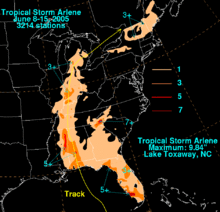
In the Florida Keys, Arlene produced wind gusts of up to 60 mph (95 km/h), causing wind damage to four homes in Lower Matecumbe Key. The storm caused a storm surge of 1.25 feet (0.38 m) above normal. Waves on top of the surge caused flooding on roads in Key West. Damage in the Florida Keys totaled to $90,000 (2005 USD).[10]
In the Florida Panhandle, the storm dropped heavy rainfall, peaking at 8.51 inches (216 mm) in Plantation Bay, Florida in Flagler County. Upon making landfall, Arlene caused a storm surge of up to 5 feet (1.5 m) in Walton County. Moderate beach erosion also occurred. The storm surge and strong waves caused moderate to severe damage to roads along the panhandle. Strong winds caused power outages to 500 people in Walton, Washington and Bay counties. The storm spawned a weak tornado in Navarre, Florida, causing minor damage on its 0.1-mile (0.2-km) path. Damage on the panhandle totaled to $3.5 million (2005 USD), $2.5 million of which was in Fort Pickens alone.[10]
Alabama
Upon making landfall, the storm produced storm tides of up to 3.9 feet (1.2 m) in height. Minor beach erosion occurred as well. Arlene dropped moderate to heavy rainfall throughout Alabama, with higher totals of up to eight inches (200 mm) to the west of Interstate 65. Four to six inches (152 mm) of rain fell in a three-hour period in the Mobile area. Several roads were temporarily impassable from the flooding, and one road was completely washed away. Wind speeds were around 20 to 30 mph (30 to 50 km/h), while wind gusts of over 60 mph (95 km/h) existed. The winds downed several trees and power lines, leaving thousands without power for several hours. With the storm following a path similar to Hurricane Ivan just nine months earlier, many trees damaged from Ivan were downed completely. In addition, several homes experienced light wind damage. The outer bands of the storm also caused numerous funnel clouds, though no tornadoes were reported. Overall, damage was light, amounting to $1.7 million (2005 USD).[10]
Elsewhere
Heavy rainfall in Towns County, Georgia forced multiple residents to evacuate from rising flood water. Numerous creeks and rivers in the northern portion of the state overflowed.[10]
Tropical Storm Arlene caused light rainfall across southeastern Mississippi, typically between 1 and 2 inches (25 to 50 mm). Effects were generally minimal.[10]
In Indiana, the remnants of Arlene dropped heavy rainfall, peaking at 4.44 inches (112.8 mm) in Evansville. In Indianapolis, 3.04 inches (75 mm) fell at the International Airport. Rainfall from the storm was 85% of the typical June rainfall level. Arlene also spawned two tornadoes. An F1 tornado developed to the southwest of Hayden on June 12. The tornado damaged several buildings and trees on its 5.3-mile (8.5-km) path, with total damage amounting to $100,000 (2005 USD). Outer rainbands also developed an F0 tornado just south of Indianapolis, downing a few tree limbs.[10]
The remnants of Arlene combined with a non-tropical system caused heavy rainfall across New York, with some locations reporting 6 to 7 inches (150 to 175 mm) of precipitation in a 2-hour period. The rainfall collected into streams and rivers, with some officials calling it a 1 in 500 year flood. The flash flooding caused at least one mudslide, and damaged several roads. The flooding forced at least 20 to evacuate from their homes, and numerous houses were damaged. Strong winds also downed trees and power lines, causing scattered power outages. Damage totaled to $6.5 million (2005 USD).[10]
See also
| Wikimedia Commons has media related to Tropical Storm Arlene (2005). |
References
- 1 2 3 4 5 National Hurricane Center. "Tropical Cyclone Report: Tropical Storm Arlene" (PDF). NOAA. Retrieved May 9, 2006.
- ↑ National Hurricane Center. "Discussion for Tropical Depression One, 11 p.m. EDT, June 8, 2005". NOAA. Retrieved May 9, 2006.
- ↑ National Hurricane Center. "Discussion for Tropical Depression One, 11 p.m. EDT, June 10, 2005". NOAA. Retrieved May 9, 2006.
- ↑ Florida State Emergency Response Team. "Tropical Storm Arlene, Situation Report #1" (PDF). Retrieved May 9, 2006.
- ↑ Minerals Management Service. "Tropical Storm Arlene Evacuation and Production Shut-in Statistics, June 10, 2005". Retrieved May 9, 2006.
- ↑ Minerals Management Service. "Tropical Storm Arlene Evacuation and Production Shut-in Statistics, June 14, 2005". Retrieved May 9, 2006.
- ↑ Bill Kaczor (June 10, 2005). "Tropical Storm Arlene soaks Cuba, gains strength as it moves toward Deep South". Associated Press. Retrieved May 21, 2009.
- ↑ Jennifer Kay (June 10, 2005). "Tropical Storm Arlene moves into Gulf of Mexico; wind speed strengthens to 55 mph (88 km/h)". Associated Press. Retrieved May 21, 2009.
- ↑ Kaczor, Bill (June 11, 2005). "Panhandle Braces for Tropical Storm Arlene". ABC. Archived from the original on 2005-11-12. Retrieved 2008-05-25.
- 1 2 3 4 5 6 7 "Storm Data and other unusual phenomena, June 2005". Look Smart and Thomson Gale. 2005. Retrieved May 9, 2006.
External links
- NHC's archive on Tropical Storm Arlene.
- The Hydrometeorological Prediction Center's (HPC) archive on Tropical Storm Arlene.
- NHC's Tropical Cyclone Report on Tropical Storm Arlene
Tropical cyclones of the 2005 Atlantic hurricane season | ||
|---|---|---|
 | ||
| ||