Transandean Highway

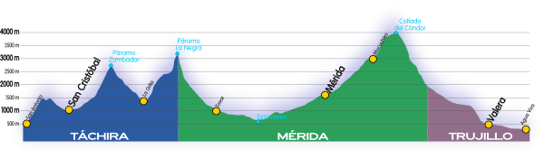
The Trans-Andean Highway (official designation Troncal 7, official name Carretera Transandina), was inaugurated on July 24, 1925. It is 1,539 km long. It runs through the Venezuelan states of Mérida, Trujillo and Táchira, from the proximities of Agua Viva up until San Cristóbal. Its highest point is located on Collado del Cóndor, at 4,118 meters (13,510 ft), making it the highest highway in Venezuela.[1]
-
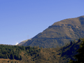
Collado del Cóndor, highest point in Trans-andean highway.
-

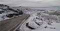
View of a snowfall on Trans-Andean Highway.
-
Most of its route has beautiful scenic views.
History
The highway was built as part of the national road plan passed by the government of former President Juan Vicente Gómez. A significant number of prisoners were involved in its construction. The road had a big impact because for the first time it connected the Andean states of Venezuela with the rest of the country and facilitated, among other things, the ability of military forces to deal with rebellions which affected the area.[2]
References
- ↑ http://www.meridapreciosa.com/paramo/ "la carretera trasandina, inaugurada por Juan Vicente Gómez en el año 1925, la cual remonta la cordillera hasta una altura máxima de 4.118 m.s.n.m, que culmina en el Collado del Nido del Cóndor, mejor conocido como Pico El Águila."
- ↑ http://tochadas.net/la-trasandina,--el-tachira-sale-de-su-aislamiento.html La Transandina, el Táchira sale de su aislamiento