Trebarwith Strand


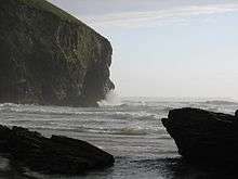
Trebarwith Strand (Cornish: Trebervedh Sian; locally sometimes shortened to The Strand), is a coastal settlement and section of coastline located on the north coast of Cornwall, England, UK, 2 1⁄2 miles (4.0 km) south of Tintagel. It has 800m of sandy beach, contained by cliffs, in which natural caves are found.
Access by road and path
The only vehicle access to the beach is via a dead-end lane running down a narrow valley from the B3263 Tintagel to Camelford road, and parking is extremely limited, particularly in high season. From Tintagel a shortcut is available through the village of Treknow, but this involves a steep descent to the stream at the south end of the hamlet, and a similar climb up from the other side of the stream.
Trebarwith Strand is accessible to walkers along the South West Coast Path from both the north and south. The footpath, running through Access Land, passes boreholes and other remnants of the cliff quarry workings which were in operation in this area from the 15th century up to the beginning of World War II.[1]
Surfing and bathing
Frequent strong swells coming in from the Atlantic Ocean make for excellent surfing and the sands are ideal for children, but the state of the tide has a major impact on the beach. As the tide comes in, the sands are swiftly submerged by the incoming seas until all that is left of the beach is the rocks at the base of the cliffs. There is a lifeguard service provided by Tintagel Surf Lifesaving Club. Unwary visitors can easily be cut off by the rising waters.[2] A number of people have to be rescued each year.[3]
Natural history
When the tide is at its lowest the sea recedes 300 yards (270 m) and an expanse of sand in excess of 1⁄2 mile (800 m) wide is uncovered, offering excellent opportunities for walking and littoral discoveries. The rockpools at the base of the cliffs create perfect places for small fish and crabs to hide until the tide turns, and there is an abundance of small molluscs such as periwinkles, limpets and mussels clinging in clusters to the rocks. In the sea beyond low water mark is Gull Rock (or Otterham Rock).
History
The name Trebarwith really belongs to the village on the higher ground to the south of the valley which is the most southerly part of Tintagel parish. Land at Trebarwith is first mentioned in records of 1284 and was held from 1329 until the early 16th century by the Lercedekne family.[4] Trebarwith Farm is a Grade II listed building.[5] The road along the valley from Penpethy to the Strand was originally built to allow the collection of sand for agricultural purposes: there are several disused slate quarries on either side of the road. At Port William to the south of the Strand was a small harbour formerly used in the export of slate.
Notable events
- 1886. Trebarwith was the scene of the shipwreck of the Sarah Anderson in October 1886 (all on board perished).[6]
- 1974. Malachi's Cove or The Seaweed Children a film, based on Anthony Trollope's story and directed by Henry Herbert was filmed largely at Trebarwith (the cast included Donald Pleasence as Malachi).[7]
- 1996, 1997 & 2000. Rugged Gull Rock, about 600 yards offshore greatly enhances the picturesque setting of the beach, which as a result is frequently used as a filming location. In recent years “Saving Grace" (2000), and “Oscar and Lucinda” (1997) both had scenes filmed here. Most famously Trebarwith Strand stood in for Shakespeare’s coast of Illyria in the 1996 production of "Twelfth Night".
- 2015. A man was swept out to sea while scattering his sister's ashes, when he was caught by a large wave.[3]
References
- ↑ Hatcher, John (1970) Rural Economy and Society in the Duchy of Cornwall 1300-1500. Cambridge University Press; pp. 34-35 ISBN 0-521-08550-0
- ↑ "Two Men and a Dog Rescued From Cornish Cliff Face After Phoning a Pub For Assistance". Maritime & Coastguard Agency. 2009-01-10. Retrieved 2009-09-23.
- 1 2 "Man scattering ashes at Trebarwith Strand swept out to sea". BBC. 1 February 2015. Retrieved 1 February 2015.
- ↑ Canner, A. C. (1982) The Parish of Tintagel. Camelford: A. C. Canner; p. 20
- ↑ "Trebarwith Farm". Retrieved 2009-03-16.
- ↑ "Wreck Report for 'Sarah Anderson', 1887 - PortCities Southampton". Plimsoll.org. 2007-10-24. Retrieved 2016-09-07.
- ↑ Malachi's Cove] (The Seaweed Children), IMDb
External links
| Wikimedia Commons has media related to Trebarwith. |
- Photographs of Trebarwith Strand on Tintagelweb
- Photographs of Trebarwith Strand on This is North Cornwall
- Photographs of Trebarwith Strand on Marhamchurch website
Coordinates: 50°38′41″N 4°45′42″W / 50.6447°N 4.7618°W