Transportation in Portland, Oregon

Like transportation in the rest of the United States, the primary mode of local transportation in Portland, Oregon is the automobile. The Metro has a regional master plan in which transit-oriented development plays a major role.[1] This approach, part of the new urbanism, promotes mixed-use and high-density development around light rail stops and transit centers, and the investment of the metropolitan area's share of federal tax dollars into multiple modes of transportation. In the United States, this focus is atypical in an era when automobile use led many areas to neglect their core cities in favor of development along interstate highways, in suburbs, and satellite cities.[2]
| “ | Portland is "an international pioneer in transit orientated developments." | ” |
| — Sayeeda Warsi, a leader of the UK's Conservative Party, from a 2006 episode of Newsnight[3] | ||

Mass transit
Portland has a comprehensive public transportation system. The bus and rail system is operated by TriMet, its name reflecting the three metropolitan area counties it serves (Multnomah, Clackamas, and Washington). Portland's rate of public transit use (12.6% of commutes in 2008) is comparable to much larger cities like Los Angeles, and higher than in most similarly sized U.S. cities, but is lower than in some others, such as Baltimore and Seattle.[4] Transit service between Portland and Vancouver, Washington, the second-largest city in the metropolitan area, is provided by C-Tran, with a small number of express routes.
Within the downtown area (the city center) is the Portland Transit Mall, a transit-priority corridor on which buses and light rail trains from many different parts of the region converge. First opened in 1977, and for three decades served only by buses, the transit mall underwent major changes in 2009. Tracks for light rail (MAX) were added, bus stops spaced farther apart, and the left lane opened to general traffic (but with right turns prohibited).[5] To facilitate this major renovation and rebuilding, lasting more than two years, all bus routes using the mall were diverted to other streets (mainly 3rd and 4th avenues) starting in January 2007.[6] The transit mall reopened to buses on May 24, 2009,[7] and operator training runs on the new light-rail tracks took place during the late spring and summer.[8] Light rail service on the transit mall was introduced on August 30, 2009, when the MAX Yellow Line moved to the mall from its previous routing.[9] The new MAX Green Line opened 13 days later, on September 12, and it also serves the downtown transit mall.[10]
From 1975 to 2010, all of downtown Portland was in Fareless Square, a fare zone within which all rides on buses, light rail and streetcars were fare-free, and starting in 2001 this zone also covered a portion of the adjacent Lloyd District. In 2010, free rides became limited to light-rail and streetcar service – no longer covering bus service – and the zone was renamed the "Free Rail Zone".[11] In September 2012, the fareless zone was discontinued entirely, due to a $12 million shortfall in TriMet's annual budget.[12]
Ben Holladay was the first person to offer public transportation to the city of Portland when in 1872 he opened the Portland Street Railway Company, a horsecar line on First Street extending to a garage at the end of Glisan.[13] In 1882, a second horsecar system was built for Third Street.[14] Ferries such as the O&CRR Ferry#2 were used to cross the Willamette River before the construction of the first Steel Bridge in 1888. At that point, rail expanded into Albina and East Portland. Horsecars took passengers across the river and steam trains took them further into the suburbs,[15] but both modes were soon replaced by electric streetcar lines, the first of which began operation on November 1, 1889, between St. Johns and Portland.[16]
Buses
TriMet operates a fleet of 610 buses on a network of 80 bus routes.[17] Twelve of the routes are designated "Frequent Service" bus routes, with more frequent schedules than other routes.[18] Originally intended to have buses scheduled every 15 minutes or less all day, every day (including weekends and holidays), budget cutbacks in 2009 caused TriMet to change "Frequent Service" routes to have 15-minute-or-less wait times only during weekday peak usage times in the morning and afternoon.[19] In August 2014, TriMet reintroduced 15-minutes-or-less wait times at all times during weekdays on Frequent Service routes, with the stated goal of reinstating weekend 15-minutes-or-less wait times on these routes.[19]
TriMet's bus fleet is made up of 30' and 40' buses, built in 1997 or later, and nearly all are low-floor buses, with only a small number of older high-floor models (built in 1997) still in service at the end of 2015. The last non-air-conditioned buses were retired in December 2015.[20] In 2012, TriMet reinstated its annual bus purchase program and will have only low-floor buses in rotation by 2017.[21]
TriMet's bus routes also include express buses from downtown Portland to South Beaverton, Sherwood and Oregon City, and express buses from Marquam Hill to Beaverton, Tigard, Southwest Portland, and Milwaukie. TriMet also has several "cross-town" routes that do not serve downtown Portland. The bus network operates predominately in a hub-and-spoke network starting with the downtown Portland transit mall, and includes outlying transit centers in Portland's suburbs.
In addition to the fixed-route service, TriMet operates a paratransit service known as LIFT which operates 254 minibuses and 15 sedans offering door-to-door service for citizens who cannot access regular TriMet services.[18]
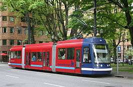
MAX light rail


Since September 2015, Portland's light rail system, named MAX (short for Metropolitan Area Express), consists of five color-coded lines:
- The Blue Line is a 33-mile (53 km) east-west route. It begins in Hillsboro, a western suburb, passes through Beaverton and downtown Portland, then across the Willamette River, through Northeast Portland and east to the city of Gresham. The 15-mile (24 km) line between downtown and Gresham was the first light rail line opened in Portland, in 1986. MAX lines first became designated by colors in 2000.
- The Red Line incorporates a 5.6-mile (9.0 km) north-south addition between the airport and the Gateway Transit Center near the northeast Portland neighborhood of Parkrose. From that point the line overlaps the Blue Line, running west to downtown and beyond, terminating at the Beaverton Transit Center, where it and the Blue Line meet WES Commuter Rail.
- The Yellow Line added 5.8 miles (9.3 km) to the system. It connects North Portland's Expo Center with downtown. This line is often referred to as "Interstate MAX" because much of it runs along Interstate Avenue, and parallel to I-5. Until 2009, the Yellow Line followed the same mostly east-west alignment through downtown Portland as used by the Blue and Red lines, traveling along Morrison Street (westbound) and Yamhill Street (eastbound) through the core of the business district. However, on August 30, 2009, the Yellow Line shifted to a new north-south alignment through downtown that had been constructed along the Portland Mall (see Green Line).[22] In 2015, the Yellow Line became through-routed at all times with the then-new Orange Line (see below).
- The Green Line runs from Clackamas Town Center, in the Clackamas area, north along I-205 for 6.5 miles (10.5 km) to the Gateway Transit Center, where the Blue and Red Lines meet. From Gateway, it joins them and travels westwards to downtown Portland along the 1986-opened tracks extending to the Steel Bridge. From there—a new junction on the bridge's west deck—the Green Line uses 1.8 miles (2.9 km) of new tracks passing Union Station and running mainly along the transit mall for the remainder of its route through downtown, sharing that routing with the Yellow Line (and since 2015 the Orange Line) and terminating at Portland State University (PSU).[10]
- The Orange Line added 7.3 miles (11.7 km) of newly constructed line, extending from the south end of the Portland Mall to Milwaukie. The project included construction of the Tilikum Crossing, the first new bridge opened across the Willamette River in Portland in 42 years (since 1973),[23] which is also notable for being open only to transit vehicles, pedestrians and cyclists—and not private vehicles.[23][24] From the PSU area in downtown, the Orange Line follows streets and a bus-and-light-rail-only viaduct to reach the South Waterfront district. After crossing the river, the line turns southward, passing through Southeast Portland along a new median on SE 17th Avenue and then mostly along or adjacent to previously existing railroad rights-of-way to downtown Milwaukie. The terminal station is at Park Avenue, just south of downtown Milwaukie. Operationally, it is linked to the Yellow Line at all times; southbound Yellow Line trains become Orange Line trains when they depart from Rose Quarter TC, and northbound Orange Line trains become Yellow Line trains when they reach the transit mall in downtown Portland.
Portland Streetcar
The Portland Streetcar is a two-line streetcar system serving the central part of Portland—downtown and the areas immediately surrounding downtown. The system's first line opened in 2001 and, with later extensions, now follows a 3.9-mile (6.3 km) route[25] from Legacy Good Samaritan Medical Center at NW 23rd Avenue through inner-Northwest and Southwest, including the Pearl District and Portland State University, to the new South Waterfront neighborhood, where it connects to the Portland Aerial Tram.[26] In 2012, this route was given the designation North-South Line, or NS Line.
The system's second line opened in 2012 and extended service across the Willamette River to the Lloyd District and the Central Eastside.[27] The federal share of funding for this $148-million project, a 3.3-mile (5.3 km) extension and fleet expansion,[27] was approved in April 2009,[28] and construction began in August 2009. Originally named the Central Loop Line, or CL Line, it was renamed the A Loop (clockwise) and B Loop (counterclockwise) in 2015, when it was extended from the eastside across the Tilikum Crossing bridge and also along the NS Line from South Waterfront to Portland State University. See Portland Streetcar (Eastside line) and Loop Service (Portland Streetcar) for more detail.
The Willamette Shore Trolley is a seasonal, volunteer-operated heritage streetcar service established in 1990 – after a 1987 trial run – for the purpose of preserving an approximately 6-mile (10 km) former Southern Pacific railroad right-of-way running south from Portland to Lake Oswego for possible future transit use. Plans to extend the Portland Streetcar along the right-of-way were mothballed in early 2012, but remain under consideration for the long term.[29] The right-of-way was acquired by a consortium of local governmental entities in 1988 for this purpose.[30]
Commuter rail
TriMet's WES Commuter Rail connects the cities of Wilsonville, Tualatin, Tigard and Beaverton. It is one of only three suburb-to-suburb commuter rail lines in the country, along with Tri-Rail in Miami and the Inland Empire-Orange County Line operated by Metrolink between San Bernardino and Oceanside, Calif. Rather than electric railcars like those of MAX, the line uses FRA-compliant diesel multiple units running on existing Portland and Western Railroad freight tracks. The first rides open to the general public took place on Friday, January 30, 2009, and regular service began on Monday, February 2, 2009.[31]
Amtrak also exists as a rail commuting option in the Portland area with the Amtrak Cascades providing daily service between Portland and neighboring Oregon City.[32] While the frequency is less than that of TriMet, the 20-minute ride from Oregon City is faster, has cheaper tickets, and is arguably a more comfortable service.[33]
See the Intercity service section below for information about the many intercity bus and train services to and from Portland from outside the metro area.
Portland Aerial Tram
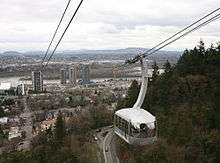
The Portland Aerial Tram is an aerial cableway used to connect the South Waterfront district with Oregon Health and Science University on Marquam Hill above. The cableway is two-thirds of one mile (1 km) long and was opened to the public in January 2007.
Cycling
Bicycle use in Portland has been growing rapidly, having nearly tripled since 2001; for example, daily bicycle traffic on four of the Willamette River bridges has increased from 2,855 before 1992 to over 16,000 in 2008, partly due to improved facilities.[34] Approximately 8% of commuters bike to work in Portland, the highest proportion of any major U.S. city and about 10 times the national average.[35] By July 2016 through a 4-0 city council vote, Portland will have a bike share program running with 600 bikes. The new bikes will be provided by Social Bicycles, and will be operated by Motivate.[36]
Walking
According to a city video, in 1994 Portland became the first city to develop a pedestrian master plan.[37] Blocks in the downtown area are only 200 feet (61 m) long. Many streets in the outer southwest section of the city lack sidewalks; however, this is partially made up with various off-street trails.[38] A 2011 study by Walk Score ranked Portland the 12th most walkable of the fifty largest cities in the United States.[39]
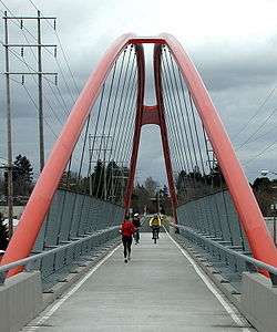
The Gibbs Street Pedestrian Bridge, a new pedestrian and bicycle bridge over I-5 near the Portland Aerial Tram, opened in 2012.[40]
Traffic flow
Many streets in Portland are one-way; streets in downtown Portland (Southwest Portland bounded by I-405 and the Willamette River) are virtually all one-way, forming a grid of alternating street traffic: for north-south streets, odd-numbered avenues (1st, 3rd, etc.) are southbound, while even-numbered avenues (2nd, 4th, etc.) are northbound, and similarly east-west streets alternate. This is partly due to the streets in downtown Portland being relatively narrow (64 feet (20 m)). This grid extends a short way west across I-405 into Goose Hollow, terminating at SW 18th Avenue, and extends to some degree north across Burnside into the Pearl District, particularly with the north-south streets extending into Old Town.
Most streets on the east side are two-way, but there are a number of one-way pairs along major routes: Martin Luther King Jr. Blvd. (MLK)/Grand Avenue (the equivalent of 4th and 5th avenues), and 11th/12th east-west pairs are connected with bridges, with NE Couch/Burnside forming a pair east of the Burnside Bridge from 3rd to 14th avenues, SE Morrison/SE Belmont forming a pair from the Morrison Bridge to SE 25th Ave, and SE Madison/SE Hawthorne forming a pair from the Hawthorne Bridge to SE 12th Avenue.
Highways
State highways, numbered as Interstate, U.S and Oregon Routes, in the metropolitan area include:
Notable highways never built, or removed altogether, include Mount Hood Freeway, Interstate 505, and Harbor Drive.[41]
Bridges
The large number of bridges in Portland has given the city its "Bridgetown" nickname.
Willamette River
Bridges over the Willamette River, listed north to south:
- St. Johns Bridge (1931) – U.S. Route 30/N Philadelphia Avenue
- Burlington Northern Railroad Bridge 5.1 (1908)
- Fremont Bridge (1973) – Interstate 405
- Broadway Bridge (1913) – Broadway
- Steel Bridge (1912) – Pacific Highway West/former Oregon Route 99W
- Burnside Bridge (1926) – Burnside Street
- Morrison Bridge (1958) – Morrison Street
- Hawthorne Bridge (1910) – Hawthorne Boulevard
- Marquam Bridge (1966) – Interstate 5
- Tilikum Crossing (2015) – Longest car-free bridge in the U.S.
- Ross Island Bridge (1922) – U.S. Route 26/Powell Boulevard
- Sellwood Bridge (1925; replacement 2016) – SE Tacoma Street
Columbia River
Bridges over the Columbia River, listed west to east:
- Burlington Northern Railroad Bridge 9.6 (1908) – the first bridge of any kind across the lower Columbia River[42]
- Interstate Bridge (1917/1958) – Interstate 5
- Glenn L. Jackson Memorial Bridge (1982) – Interstate 205
Intercity service
Long-distance passenger rail service to Portland is provided by Amtrak, the national passenger rail system, with trains stopping at Union Station. Amtrak routes serving Portland include the Amtrak Cascades (with service to/from Vancouver, British Columbia and Eugene, Oregon), the Coast Starlight (with service to/from Los Angeles and Seattle) and the Empire Builder (with service to/from Portland and Chicago).
While long-distance rail options are somewhat limited and infrequent, Oregon has a well-connected intercity bus network offering numerous options for travel to and from the Portland metro area. The Cascades POINT provides daily service between Portland and Eugene, with stops at every Amtrak station in the Willamette Valley.[43] The NorthWest POINT provides daily service between Portland and Astoria, with stops in several rural communities along U.S. Route 26 and towns along the Oregon Coast.[44] BoltBus began offering service from Portland in May 2012, with Seattle as its first destination.[45] Additional bus services that bring passengers to and from the Portland area include Columbia County Rider from St. Helens, Tillamook County Transportation District's service from Tillamook, the Central Oregon Breeze from Bend, and more.
Airports
Portland's main airport is the Portland International Airport (IATA: PDX, ICAO: KPDX), located in the northeast quadrant, near the Columbia River, and 20 minutes by car from downtown. PDX is also connected to the downtown business and arts districts by the MAX Red Line. The city's first airport, Swan Island Municipal Airport, opened in 1927 and closed in the 1940s.
The Port of Portland's Hillsboro Airport (IATA: HIO, ICAO: KHIO) is an executive and general aviation airport located in Hillsboro, Oregon, and it the second busiest airport in the state. It is connected to the metropolitan area by the MAX Blue Line, and is the starting point for many corporate and charter flights, including Nike, Inc.. Hillsboro is currently being considered for commercial traffic to relieve the increasingly congested PDX.
Troutdale Airport also serves the area. Portland is also served by Wiley's Seaplane Port, a private seaplane base on the Willamette.
Portland is home to Oregon's only public use heliport, the Portland Downtown Heliport (ICAO: 61J).
Other alternatives
Portlanders living downtown or in nearby neighborhoods have car sharing as an alternative, through Zipcar, which acquired Flexcar in 2007.[46] As of 2005, there are over 5,000 members sharing 70 vehicles which are located in neighborhoods such as the Pearl District, Old Town Chinatown, the Lloyd District, Hawthorne, and Brooklyn.
Skateboarding and roller blading are welcome methods for travel around town. Downtown Portland includes signs labeled "skate routes" to aid the urban skater.[47] The Wall Street Journal stated Portland "may be the most skateboard-friendly town in America."[48]
See also
- Rose City Transit, TriMet's Portland-only predecessor
- Transportation in Seattle and Transportation in Vancouver for Pacific Northwest comparisons
Notes
- ↑ http://library.oregonmetro.gov/files//tod_final_report.pdf
- ↑ Timothy Egan (May 31, 1987). "Focus: Portland; So Long Cars, Hello People". The New York Times. Retrieved July 31, 2012.
- ↑ Where the car is not king, a 15 August 2006 BBC News article on Portland transportation
- ↑ "American Community Survey 2006, Table S0802". U.S. Census Bureau.
- ↑ Rose, Joseph (January 22, 2009). "Weave through TriMet's work in downtown Portland". The Oregonian. Retrieved April 15, 2013.
- ↑ Redden, Jim (January 12, 2007). "Bye-bye, bus mall as we know it". Portland Tribune. Retrieved December 19, 2012.
- ↑ Rivera, Dylan (May 26, 2009). "Buses return to Portland's revamped transit mall". The Oregonian. Retrieved October 1, 2009.
- ↑ "Light-rail operator training begins on Portland Mall". Portland Business Journal. May 1, 2009. Retrieved October 1, 2009.
- ↑ "New MAX line opens downtown". Portland Tribune. August 28, 2009. Archived from the original on June 8, 2011. Retrieved February 24, 2016.
- 1 2 Rivera, Dylan (September 13, 2009) [online date September 12]. "Riders pack MAX Green Line on first day of service". The Oregonian. Retrieved February 24, 2016.
- ↑ "Better have that bus fare today; Fareless Square ends". Portland Tribune. January 4, 2010. Retrieved December 19, 2012.
- ↑ Bailey Jr., Everton (August 30, 2012). "TriMet boosts most fares starting Saturday; some routes changing". The Oregonian. Retrieved September 1, 2012.
- ↑ Labbe, John T. (1980). Fares, Please! Those Portland Trolley Years. Caldwell, Idaho: Caxton Printers, Ltd. p. 18. ISBN 0-87004-287-4.
- ↑ Labbe, p. 19
- ↑ Labbe, pp. 20–21
- ↑ "Cars Running By Electricity; Formal Opening of the Portland–St. John's Line Yesterday". (November 2, 1889). The Morning Oregonian, p. 7.
- ↑ "TriMet At-a-Glance" (PDF). TriMet. February 2015. p. 6. Retrieved February 24, 2016.
- 1 2 "TriMet-At-a-Glance 2014" (PDF). TriMet. February 2014. Retrieved 2014-09-10.
- 1 2 "Frequent Service". TriMet. Retrieved September 9, 2014.
- ↑ "The Year in Review: 2015". How We Roll. TriMet. December 31, 2015. Retrieved 2016-02-24.
- ↑ "The first batch of 70 new buses rolls into service Tuesday, July 23". TriMet. July 22, 2013. Retrieved September 10, 2014.
- ↑ "MAX Yellow Line: Route and schedule changes effective August 30, 2009". TriMet. August 29, 2009. Retrieved October 1, 2009.
- 1 2 Newcomb, Tim (August 20, 2015). "Portland Is Set To Open a Beautiful $135 Million Bridge You Can't Drive Across". Popular Mechanics. Retrieved February 24, 2016.
- ↑ Libby, Brian (October 2015). "Bridge to the Future (The Bridge that Bans Cars)". The Atlantic. 316 (3): 42–43. Retrieved September 27, 2015.
- ↑ Morgan, Steve. "Expansion for Portland's MAX: New routes and equipment", pp. 38-40. Passenger Train Journal, "2010:1" issue (1st quarter, 2010). White River Productions.
- ↑ Portland Streetcar: Streetcar History from portlandstreetcar.org
- 1 2 Redden, Jim (September 22, 2012). "East side streetcar service begins". Portland Tribune. Retrieved December 27, 2012.
- ↑ "Feds give $75 million for Oregon streetcar". Portland Business Journal. April 30, 2009. Retrieved December 27, 2012.
- ↑ Bailey Jr., Everton (January 25, 2012). "Lake Oswego officially suspends streetcar plans with goal of retaining Willamette Shore right-of-way for future transit use". The Oregonian. Retrieved February 28, 2014.
- ↑ "Lake Oswego to Portland transit project: Willamette Shore line right-of-way". Metro. Retrieved February 28, 2014.
- ↑ Leah Weissman (February 5, 2009). "WES' first day — 'I plan on using it every day'". Beaverton Valley Times. Retrieved November 19, 2015.
- ↑ http://amtrakcascades.com/Schedules.htm
- ↑ http://www.oregonlive.com/pacific-northwest-news/index.ssf/2012/03/amtrak_gaining_popularity_amon.html
- ↑ Portland Bicycle Counts 2008 (PDF), City of Portland
- ↑ Dougherty, Conor (May 16, 2009). "'Youth Magnet' Cities Hit Midlife Crisis". The Wall Street Journal. Retrieved October 18, 2010.
- ↑ Njus, Elliot (September 23, 2015). "Portland City Council signs off on new bike-share program". OregonLive. Retrieved September 24, 2015.
- ↑ Portland Walks - Be Safe from the City of Portland website
- ↑ SW Urban Trails, a website of the neighborhood coalition for southwest Portland
- ↑ "2011 City and Neighborhood Rankings". Walk Score. 2011. Retrieved Jan 23, 2013.
- ↑ Koffman, Rebecca (July 12, 2012). "New pedestrian and bicycle bridge across Interstate 5 opens Saturday in Southwest Portland". The Oregonian. Retrieved August 10, 2012.
- ↑ Young, Bob (March 9, 2005). "Highway to Hell". Willamette Week. Retrieved November 20, 2016.
- ↑ "Finish Bridge Over Columbia; Steel Structure of the Spokane, Portland & Seattle Railroad [sic] Completed—Last Bolt In Yesterday". (June 26, 1908). The Morning Oregonian, p. 11. Retrieved 2015-11-19.
- ↑ http://oregon-point.com/cascades_point_schedules.php
- ↑ http://oregon-point.com/nw_point_schedules.php
- ↑ Lindblom, Mike (May 7, 2012). "Low-cost bus line to Portland on track to compete against Amtrak". Seattle Times. Retrieved May 8, 2012.
- ↑ "Seattle's Flexcar merges with rival Zipcar". Seattle Times. October 31, 2007. Retrieved January 23, 2011.
- ↑ "Skate Route from Wed09Jul2003 Portland III - Djangos, 23rd, Cultural District, OSCON". Archived from the original on September 28, 2003. Retrieved August 25, 2005.
- ↑ Dougherty, Conor (July 30, 2009). "Skateboarding Capital of the World". The Wall Street Journal. Retrieved July 31, 2009.
External links
- City of Portland's Office of Transportation
- Oregon Department of Transportation's TripCheck, including a speed-of-traffic map (in GIF format)
- ODOT's Portland-area projects
- TriMet
- Portland's Bicycle Transportation Alliance
- Portland SHIFT to Bikes
- Multnomah County bridges
 | ||