Transportation in Connecticut
| Overview | |
|---|---|
| Transit type | Rapid transit, commuter rail, buses, private automobile, Taxicab, bicycle, pedestrian |
| Operation | |
| Operator(s) | Connecticut Department of Transportation |
The transportation system of Connecticut is a cooperation of complex systems of infrastructure. Trains and highways are the central pieces of the system.
Transit systems
Rail
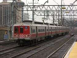
Southwestern Connecticut is served by MTA's Metro-North Railroad New Haven Line, providing commuter service to New York City and New Haven, with branches servicing New Canaan, Danbury, and Waterbury. Connecticut lies along Amtrak's Northeast Corridor which features frequent Northeast Regional and Acela Express service. Towns between New Haven and New London are also served by the Shore Line East commuter line. Operation of commuter trains from New Haven to Springfield on Amtrak's New Haven-Springfield Line is under consideration.[1] Amtrak also operates a shuttle service between New Haven and Springfield, Massachusetts, servicing Hartford and other towns on the corridor.
Bus
Statewide bus service is supplied by Connecticut Transit, owned by the Connecticut Department of Transportation, with smaller municipal authorities providing local service. Bus networks are an important part of the transportation system in Connecticut, especially in urban areas like Hartford, Stamford, Norwalk, Bridgeport and New Haven. The state also operates CTfastrak, a bus rapid transit line linking New Britain and Hartford.[2][3][4]
Roads and freeways
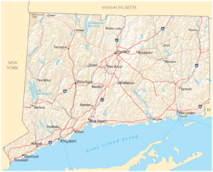
The Interstate highways in the state are I-95 (the majority of the Connecticut Turnpike) traveling southwest to northeast along the coast, I-84 traveling southwest to northeast in the center of the state, I-91 traveling south to north in the center of the state, and I-395 (the rest of the Connecticut Turnpike) traveling south to north near the eastern edge of the state. The other major highways in Connecticut are the Merritt Parkway and Wilbur Cross Parkway, which together form Route 15, traveling from the Hutchinson River Parkway in New York State parallel to I-95 before turning north of New Haven and traveling parallel to I-91, finally becoming a surface road in Berlin. Route 15 and I-95 were originally toll roads; they relied on a system of toll plazas at which all traffic stopped and paid fixed tolls. A series of terrible crashes at these plazas eventually contributed to the decision to remove the tolls in 1988.[5] Other major arteries in the state include U.S. Route 7 (US 7) in the west traveling parallel to the NY state line, Route 8 farther east near the industrial city of Waterbury and traveling south to north along the Naugatuck River Valley nearly parallel with US 7, and Route 9 in the east.
Between New Haven and New York City, I-95 is one of the most congested highways in the United States. Many people now drive longer distances to work in the New York City area. This strains the three lanes of traffic capacity, resulting in lengthy rush hour delays. Frequently, the congestion spills over to clog the parallel Merritt Parkway. The state has encouraged traffic reduction schemes, including rail use and ride-sharing.[6]
Connecticut also has a very active bicycling community, with one of the highest rates of bicycling ownership and use in the United States. New Haven's cycling community, organized in a local advocacy group called ElmCityCycling, is particularly active. According to the U.S. Census 2006 American Community Survey, New Haven has the highest percentage of commuters who bicycle to work of any major metropolitan center on the East Coast.
Bridges and tunnels
The Heroes Tunnel on the Wilbur Cross Parkway is the only tunnel in Connecticut to pass under a natural obstacle, though there are other vehicular tunnels in Hartford and New Haven. Connecticut has many bridges, especially along the coast of Long Island Sound.
Port Infrastructure
Airports
Bradley International Airport is located in Windsor Locks, 15 miles (24 km) north of Hartford. Regional air service is provided at Tweed New Haven Regional Airport. Larger civil airports include Danbury Municipal Airport and Waterbury-Oxford Airport in western Connecticut. Sikorsky Memorial Airport is located in Stratford and mostly services cargo, helicopter and private aviation. The Westchester County Airport in Harrison, New York serves much of southwestern Connecticut.
Current, future and proposed projects
The Long Island Sound link is a proposed bridge or tunnel that would link Long Island with either Connecticut or New York across the Long Island Sound. The currently proposed tunnel, however, does not enter Connecticut.
References
- ↑ "NHHS Rail". NHHS Rail. 2010-07-19. Retrieved September 15, 2011.
- ↑ "Despite Snow, Thousands of Riders, Many First-Timers, Experience CTfastrak on First Day of Service" (Press release). Connecticut Department of Transportation. 28 March 2015. Archived from the original on 11 September 2015.
- ↑ "What Is CTfastrak". State of Connecticut. Retrieved 18 October 2013.
- ↑ LaPorte, Mike (5 November 2014). "The Busway to the Future: Insider to CTfastrak before Opening to Public". The Live Wire. Manchester Community College. Retrieved 11 December 2014.
- ↑ Connecticut Turnpike (I-95) nycroads.com
- ↑ "ctrides.com". ctrides.com. 2010-04-15. Retrieved 2010-07-25.
