Transport in Switzerland
Being in the center of Europe, Switzerland has a dense network of roads and railways. The Swiss public transport network has a total length of 24,500 kilometers and comprises more than 2600 stations and stops.
The crossing of the Alps is an important route for European transportation, as the Alps separate Northern Europe from Southern Europe. Alpine railway routes began in 1882 with the Gotthard Railway with its central Gotthard Rail Tunnel, followed in 1906 by the Simplon Tunnel and the Lötschberg Tunnel in 1913. As part of the New Railway Link through the Alps (NRLA) in 2007 the Lötschberg Base Tunnel opened and in 2016 the Gotthard Base Tunnel opened on June 1st.[1]
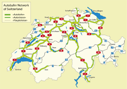
The Swiss road network is funded by road tolls and vehicle taxes. The Swiss motorway system requires the purchase of a road tax disc - which costs 40 Swiss francs - for one calendar year in order to use its roadways, for both passenger cars and trucks. The Swiss motorway network has a total length of 1,638 kilometres (as of 2000) and has also - with an area of 41,290 km2 - one of the highest motorway densities in the world.
Zurich Airport is Switzerland's largest international flight gateway, handling 24.9 million passengers in 2013.[2] The second largest airport, Geneva Cointrin, handled 14.4 million passengers (2013) and the third largest Basel-Mulhouse-Freiburg Airport 6.5 million passengers, both airports being shared with France.
Switzerland has approved billions of Francs for the improvement of its public transportation infrastructure. The modal split for public transportation is one of the highest in Europe, standing at 21.3% in 2010.[3] In many cities with a population above 100,000, the modal split for public transportation lies above 50%.
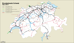
Railways
Switzerland has a very high density of railway network, with an average of 122 km of track for every 1,000 km2 (average of 46 km in Europe).[4] In 2008, each Swiss citizen traveled, on average, 2,422 km by rail, which makes them the most frequent users of rail transport.[5]
Many of the Swiss standard gauge railway lines are part of the nationwide Swiss Federal Railways system, although other standard gauge lines are operated by independent companies such as BLS AG. In addition numerous narrow gauge railways are operated, the largest company of its kind being the Rhaetian Railways. In total 5,100 km of rail network are used.
The Swiss Federal Railways run some 5000 passenger trains covering approximately 274,000 kilometres daily, half of which are trains operated by long distance services the other half being regional and suburban services. In 2013, 366 million passengers used the Swiss Federal Railways.
Rail transport in Switzerland also include car and truck transportation service (German: Autoverlad). But for private cars it is limited in some mountainous areas where the passes are closed in winter or simply does not exist (Lötschberg railway line).
Urban rail
Urban commuter rail networks are focused on the country's major cities: Zurich, Geneva, Basel, Bern, Lausanne and Neuchâtel.
Lausanne is the only city with a metro system (Lausanne Metro), which includes two lines, the first being light rail, while the other being a fully automated metro opened in 2008. After its opening, Lausanne replaced Rennes as the smallest city in the world to have a full metro system.
Maglev
In response to the increasing need of transport capacity and the cost of ground surface infrastructures, an underground transportation has been proposed and studied. The train would use linear motor and magnetic levitation to reach speeds about 500 km per hour. The project is not likely to be realized in the near future but a license for application has been deposited for a pilot-line between Geneva and Lausanne.
Mountain rail
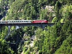
Trains cannot climb steep gradients, so it is necessary to build lot of track in order to gain height gradually. Transversals through the Alps were made possible with the use of hidden circular tunnels, which are called Spiral. In the case of extremely mountainous terrain, railway engineers opted for the more economical narrow gauge construction.
The many railway viaducts of the Rhaetian railways in the canton of Graubünden, built for the most part in the early 20th century, have become a tourist attraction as well as a necessary transport system, drawing rail enthusiasts from all over the world.
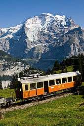
Some railways were built only for tourist purposes as the Gornergrat or the Jungfraujoch, Europe's highest station in the Bernese Oberland, at an altitude of 3,454 metres (11,330 ft).
Roads
.jpg)
Switzerland has a network of two-lane national roads. These roads usually lack a median or central reservation. Some stretches are controlled-access, in that all traffic must enter and exit through ramps and must cross using grade separations.
Two of the important motorways are the A1, running from St. Margrethen in northeastern Switzerland's canton of St. Gallen through to Geneva in southwestern Switzerland, and the A2, running from Basel in northwestern Switzerland to Chiasso in southern Switzerland's canton of Ticino, using the Gotthard Road Tunnel.
Autobahn (plural: Autobahnen) is the German name; in French-speaking Switzerland they are known as autoroutes, and in Italian-speaking Switzerland they are known as autostrade (singular: autostrada). Swiss motorways have general speed limits of 120 km/h (75 mph).
| Total | National roads | Cantonal roads | Municipal roads |
|---|---|---|---|
| 71,345.6 km | 1,763.6 km | 18,136 km | 51,446 km |
Road passenger transport
Local bus services cover the whole country. Postauto cover the smaller urban areas and every region not connected to the rail network.
Switzerland also has a well-developed network of car sharing organised by the Mobility Carsharing cooperative.
Air transport
- 64 (2012)
- Airports - with paved runways
- total: 41
- over 3,047 m: 3
- 2,438 to 3,047 m: 2
- 1,524 to 2,437 m: 13
- 914 to 1,523 m: 6
- under 914 m: 17 (2012)
- Airports - with unpaved runways:
- total: 23
- under 914 m: 23 (2012)
- Heliports: 1
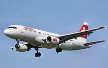
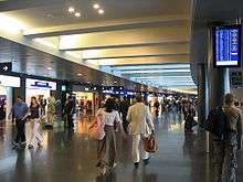
Zurich Airport (IATA: ZRH, ICAO: LSZH) also called Kloten Airport, located in Kloten, canton of Zurich, is Switzerland's largest international flight gateway and hub to Swiss International Air Lines and Lufthansa. The second largest, Geneva Cointrin International Airport, handled 10.8 million passengers and the third largest, EuroAirport Basel-Mulhouse-Freiburg, 4.3 million passengers, both airports being shared with France.
In 2003, Zurich International completed an expansion project in which it built a car park, a midfield terminal, and an automated underground train to move passengers between the existing terminal complex and the new terminal.
Zurich International lost traffic when Swissair shut down its operations. When Lufthansa took over its successor Swiss International Air Lines (SWISS), traffic grew again.
Zurich airport railway station (Zürich Flughafen) is underneath the terminal. There are trains to many parts of Switzerland; frequent S-Bahn services, plus direct Inter-regio and intercity services to Winterthur, Bern, Basel and Lucerne (Luzern). By changing trains at Zürich Hauptbahnhof most other places in Switzerland can be reached in a few hours.
Zurich Airport handled 19.2 million passengers in 2006.
Water transport
Inland waterways
- 65 km; Rhine (Basel to Rheinfelden, Schaffhausen to Bodensee)
- 12 navigable lakes
- The Interlaken Ship Canal
- The Nidau-Büren Canal
- The Thun Ship Canal
Ports and harbors
Switzerland is a landlocked country and has only small ports on its rivers, such as the Port of Basel.
Merchant marine
- total: 38 ships (1,000 GRT or over) 597,049 GRT/1,051,380 metric tons deadweight (DWT)
- ships by type: bulk 19, cargo 9, chemical tanker 5, container 4, petroleum tanker 1
Ship lines on lakes
- Compagnie Générale de Navigation sur le lac Léman on Lake Geneva
- Zürichsee-Schifffahrtsgesellschaft on Lake Zurich
Pipelines
crude oil 95 km; natural gas 1,681 km; refined products 7 km (2010)
See also
- AlpTransit
- List of mountain passes in Switzerland
- List of mountains of Switzerland accessible by public transport
- Vehicle registration plates of Switzerland
- Swiss Transport Museum
- List of Swiss tariff networks
References
Notes
- ↑ "Overview". The AlpTransit Portal. Berne, Switzerland: Swiss Federal Archives SFA, Swiss Federal Office of Transport FOT, Swiss Confederation. 2016. Retrieved 18 June 2016.
- ↑ http://www.flughafen-zuerich.ch/~/media/FlughafenZH/Dokumente/Das_Unternehmen/Flughafen_Zuerich_AG/Statistikbericht_2012.pdf
- ↑ http://epp.eurostat.ec.europa.eu/statistics_explained/index.php?title=File:Modal_split_of_inland_passenger_transport,_2000_and_2010_(1)_(%25_of_total_inland_passenger-km)-de.png&filetimestamp=20130912125052
- ↑ Rail swissworld.org
- ↑ Schienenverkehr admin.ch (German)
_(%25_of_total_inland_passenger-km)-de.png&filetimestamp=20130912125052)
Bibliography
- Brown, Leslie; McKendrick, Joe (1994). Paddle Steamers of the Alps. Kilgetty, Pembrokeshire: Ferry Publications. ISBN 1871947197.
External links
| Wikimedia Commons has media related to Transport in Switzerland. |
- http://www.autobahnen.ch/ — A website about Swiss motorways