Transport in Sheffield
Transport in Sheffield, England is developed around the city's unusual topography and medieval street plan. Once an isolated town, the transport infrastructure changed dramatically in the 19th and 20th centuries. The city now has road and rail links with the rest of the country, and road, bus and trams for local transport.
National and international travel

Sheffield is linked into the national motorway network via the M1 and M18 motorways. The M1 skirts the north-east of the city, linking Sheffield with London to the south and Leeds to the north; the M18 branches from the M1 close to Sheffield, linking the city with Doncaster, Robin Hood Doncaster Sheffield Airport and the Humber ports. The Sheffield Parkway connects the city centre with the motorways.
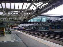
The topography of Sheffield makes it unsuitable for a large rail system. The Midland Main Line is the major railway through Sheffield, running in approximately a south-west to north-easterly direction. Other routes passing through the city include the Cross Country Route, the Penistone Line, the Dearne Valley Line, the Hope Valley Line, and the Hallam Line. The major station serving the city, Sheffield Station, is on the south-eastern edge of the city centre. There is another major rail station at Meadowhall and four smaller suburban stations at Chapeltown, Darnall, Dore and Woodhouse. Passenger rail services through Sheffield are provided by East Midlands Trains, CrossCountry, TransPennine Express, and Northern Rail.[1]
The closest international airport to Sheffield is Robin Hood Airport Doncaster Sheffield, which is located 18 miles from the city centre. The Airport opened on 28 April 2005 with the first flight to Palma de Mallorca. It replaced Sheffield City Airport, which opened in 1997 but is now closed to commercial airliners. Manchester Airport, Leeds Bradford International Airport and East Midlands Airport all lie within a one hour's drive of the city. London St Pancras station, the terminus of the Midland Main Line is the home to Eurostar International services since 14 November 2007.
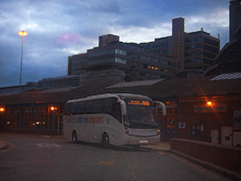
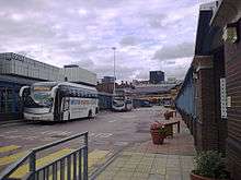
Sheffield is also served by a number of coach services. National Express Coaches provides most services, using Sheffield Interchange, Meadowhall Interchange and Meadowhead Bus stop as pick up/drop off points. Sheffield Interchange handles most services and is the start point/terminus for a number of them.[2][3][4] Sheffield is connected to London Victoria by the 560 - 564 services, with Sheffield serving as the terminus/starting point on some occasions (on others, it will be Rotherham, Barnsley, Leeds or Halifax).
Being at the confluence of several natural waterways, the development of a canal system marked an important evolution in the city's transport network, initially for commercial use and, more recently, for leisure activities. The Sheffield and South Yorkshire Navigation (S&SY) is a system of navigable inland waterways (canals and canalised rivers) in Yorkshire and Lincolnshire, England.
Chiefly based on the River Don, it runs for a length of 43 miles (69 km) and has 29 locks. It connects Sheffield, Rotherham, and Doncaster with the River Trent at Keadby and (via the New Junction Canal) the Aire and Calder Navigation.
Local travel
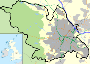
The A57 and A61 roads are the major trunk roads through Sheffield. These run east-west and north-south, respectively, crossing in the city centre. Other major roads generally radiate spoke-like from the city centre. An inner ring road, mostly constructed in the 1970s and extended to form a complete ring in 2007-2008, allows traffic to avoid the city centre, and an outer "ring road" runs around the eastern edge of the city. The inner ring-road follows St Mary's Road, Upper Hanover Street and then traverses Netherthorpe, to reach Shalesmoor. The Sheffield Outer Ring Road follows much of Prince of Wales Road from 'Arena Square' in Carbrook to Greenhill at Greenhill roundabout where it joins the A61.
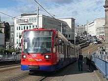
Public transport is provided by trams and buses. The Tramway system, known as the "Sheffield Supertram", is operated by Stagecoach Sheffield under the brand Stagecoach Supertram. It was constructed in the early 1990s, with the first section opening in 1994 and consists of three spokes that run from the city centre out to Hillsborough, Halfway, and Meadowhall Centre.[5]
A sizeable bus infrastructure operates from a main hub at Sheffield Interchange. Other bus stations lie at Meadowhall, Hillsborough, and Crystal Peaks.
A flurry of new operators were created after deregulation in the 1980s. The majority of these gradually amalgamated, leaving First South Yorkshire (formerly Mainline and First Mainline) owned by to operate most of the city's buses up until December 2005, when Stagecoach took over Yorkshire Traction (which had previously taken over Yorkshire Terrier, creating Stagecoach Sheffield). Stagecoach Yorkshire, Stagecoach in Chesterfield, Stagecoach in Mansfield, Veolia Transport (Operating for Travel South Yorkshire), Sheffield Community Transport, Hulleys of Baslow, Powell's Co, K&H Doyle also operating bus routes in the city. A city centre free bus service also runs every 7 minutes, known as the FreeBee.
For cycling, although the city is hilly, Sheffield is compact and has few major trunk roads running through it. It is on the Trans-Pennine Trail, a National Cycle Network route running from Southport in the north-west to Hornsea in the East Riding, and has a developing Strategic Cycle Network within the city. Sheffield is close to the Peak District National Park, an area of outstanding natural beauty popular with both on and off-road cyclists.
History
Early history
The earliest known roads in the Sheffield area date from the Roman occupation of Britain between 43 and 410 AD. The Romans built a fort at Templeborough c55. Two roads were built to this fort. Icknield Street ran south towards Derby,[6] and another road ran south-west to Brough-on-Noe near Hope in Derbyshire.[7][8] The exact course of these roads is unknown but both are likely to have passed within the modern boundaries Sheffield.[9] In the centuries after the end of the Roman occupation the Sheffield area was at the border of the Anglo-Saxon kingdoms of Northumbria and Mercia. The village of Dore (literally a Door) lay on an important route between these kingdoms.[10]
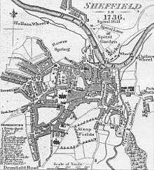
Following the Norman Conquest of England a castle was established in the village of Sheffield c1150. Sheffield began to grow into a small town, the first bridge was built over the River Don (Lady's Bridge) and the street pattern that would persist for centuries was laid out. Lady's Bridge may represent the main route out of Sheffield in this era, travellers followed the Wicker and then climbed Spital Hill to follow an ancient Dyke called the "Roman Rig" to Mexborough. This may be the route into Sheffield described in Sir Walter Scott's Ivanhoe.[8] A route to the south passing through Little Sheffield, Heeley, and Newfield Green, to Gleadless Moor existed by 1692, but was a difficult route to follow. There was also a route to the west, known as Long Causeway, that followed the old Roman Road toward Stanage Edge, however Sheffield remained relatively secluded, a fact which may have influenced the choice of Sheffield for the imprisonment of Mary, Queen of Scots, in 1570.[11]
In the 18th century, turnpike roads were built improving Sheffield's connections with the outside world.[12] A turnpike to Chesterfield was built in 1756 and another through Ringinglow to Chapel-en-le-Frith or Buxton was constructed in 1758. Roads were also built to Barnsley, Tickhill, Worksop, Intake and Penistone. The Baslow turnpike (Abbeydale Road) opened in 1805[13] and Glossop Road opened in 1821. In 1774 a wooden waggonway was laid over a distance of 2 miles from the Duke of Norfolk's collieries into the town, this was later relaid with cast-iron L-shaped rails by John Curr; one of the earliest railways to use this type of rails.[14]
19th century
The opening of the Sheffield Canal in 1819[15][16] opened Sheffield to the large-scale transportation of freight. This was followed by the Sheffield and Rotherham Railway in 1838, with Sheffield's first railway station opening at the Wicker.[17] The first main line railway station in Sheffield was opened in 1845 at Bridgehouses by the Sheffield, Ashton-under-Lyne and Manchester Railway.[18] This line was extended to a new station, Sheffield Victoria Station in 1851, and Wicker station was replaced by Sheffield Midland station in 1870. A horse tramway opened from Lady's Bridge to Attercliffe in 1873, this was later extended to Brightside and Tinsley. Further horse tramway routes were constructed to Hillsborough, Heeley, and Nether Edge.[19][20] There was an unsuccessful trial of Steam trams in 1877 and 1878. Due to the narrow medieval roads the tramways were initially banned from the town centre. An improvement scheme was passed in 1875, this led to the first major alterations to the medieval street plan, Pinstone Street and Leopold Street were constructed by 1879 and Fargate was widened in the 1880s. The 1875 plan also called for the widening of High Street, but disputes with property owners delayed this until 1895.[21]
The S&SY Navigation company was formed in 1888 with the intention of purchasing all of the waterways which were then owned by Manchester, Sheffield and Lincolnshire Railway. After seven years of negotiation, this was accomplished in 1895, and the navigation was formed by the amalgamation of the component waterways which included the Stainforth and Keadby Canal, the River Don Navigation, and the Sheffield and Tinsley Canal.
20th century to the present

The first electric tram route ran from Nether Edge to Tinsley, opening in 1899. The electrification of the rest of the system followed soon after, and the last horse tram ran in 1902. In 1910 Sheffield tram routes covered a total of 39 miles, subsequent extensions would increase this to 48 miles by 1951.[22] Tram routes started to be abandoned and be replaced by buses from 1952. When the last public service tram ran from Leopold Street to Beauchief on 8 October 1960[23] the occasion was marked with a parade of 15 trams (three of which are now preserved at the National Tramway Museum in Crich). The Beeching Axe led to the closure of the Great Central Railway route to London in 1966, followed by the Woodhead route to Manchester in 1970.[24] This left Victoria station obsolete; it closed on 5 January 1970 and the station buildings were demolished in 1989, leaving the Wicker Arches on which it stood standing. Proposals for a new tram system first appeared in the 1970s. After much deliberation routes were selected and construction of the new system, named Sheffield Supertram started in 1991. The first line, running from Castle Square to Meadowhall opened on 21 March 1994.
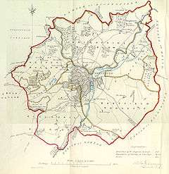
South Yorkshire County Council (SYCC) was created in 1974, comprising several neighbouring metropolitan boroughs; Sheffield, Barnsley, Doncaster and Rotherham. The metropolitan county councils created at this time, were given the responsibility for the provision of public transport. In the case of the SYCC this was allocated to the new South Yorkshire Passenger Transport Executive (SYPTE). SYPTE assumed control of the former local corporation bus fleets and also took on a coordinating role regarding the services provided by other bus operators and by British Rail in their region, in addition to becoming the highway authority for the area. During this period bus services received a subsidy of up to 85% of operating costs, and low fares contributed to an increase in bus travel of 7% from 1974–1984, compared with a 30% decline elsewhere in the United Kingdom.[25]
The metropolitan county councils, were abolished in 1986 but, despite the disappearance of the SYCC, the SYPTE remained, under the control of a Passenger Transport Authority (SYPTA) which included the four borough councils involved. By contrast, the functions of local highway authority passed directly to each of the councils, and the Sheffield City Council (SCC) thus became the responsible for city's highways.
Deregulation of UK bus services in 1986 brought an end to the local authority's direct control of the provision of local bus services, in essence leaving the bus companies to decide where, when and how often to run services, and compete commercially with each other although SYPTE still maintains an advisory role and funds the running of some non-commercially viable routes that are considered socially essential.
Bibliography
- Batty, S. (1984). Rail Centres: Sheffield. Shepperton, Surrey: Ian Allan Limited. ISBN 1-901945-21-9.
- Fox, Peter (1990). The Midland Line in Sheffield. Sheffield: Platform 5 Publishing Limited. ISBN 1-872524-16-8.
- Leader, R.E. (1906). The Highways and Byways of Old Sheffield. A lecture delivered before the Sheffield Literary and Philosophical Society. (transcription)
- Olive, Martin (1994). Images of England: Central Sheffield. Stroud: Tempus Publishing Limited. ISBN 0-7524-0011-8.
- Twidale, Graham H.E. (1995). A Nostalgic Look At Sheffield Trams Since 1950. Peterborough: Silver Link Publishing, Limited. ISBN 1-85794-040-7.
- Vickers, J. Edward MBE (1999). Old Sheffield Town. An Historical Miscellany (2nd ed.). Sheffield: The Hallamshire Press Limited. ISBN 1-874718-44-X.
- Wiseman, Richard (1997). Sheffield Trams in Colour Since 1950. Shepperton, Surrey: Ian Allan Publishing. ISBN 0-7110-2535-5.
References and notes
- ↑ UK rail network map (PDF) showing which train companies operate on each route. Provided by National Rail Enquiries (URL accessed 28 December 2005)
- ↑ "Coach Timetables for Halifax, Huddersfield, Barnsley, Sheffield & London" (PDF). National Express Coaches. National Express. March 2009. Retrieved 16 August 2009.
- ↑ "Coach Timetables for Bradford, Leeds and Sheffield to Heathrow & Gatwick" (PDF). National Express Coaches. National Express. March 2009. Retrieved 1 August 2009.
- ↑ "National Express Coach Timetables for Sheffield". Travel Search/National Express Coaches. Carl Berry. March 2009. Retrieved 1 August 2009.
- ↑ Stagecoach Supertram:About Us (URL accessed 28 December 2005)
- ↑ Wood, Michael (2001). "Tinsley Wood". In Search of England: Journeys into the English past. Penguin Books Limited. ISBN 0-520-23218-6.
- ↑ Hunter, Joseph (1819). Hallamshire. The History and Topography of the Parish of Sheffield in the County of York. London: Lackington, Hughes, Harding, Mayor & Jones. (wikisource)
- 1 2 Leader, The Highways and Byways of Old Sheffield
- ↑ Possible courses for these roads are shown on a map of Roman roads in Britain
- ↑ Vickers, Old Sheffield Town, pp. 64–68
- ↑ Vickers, Old Sheffield Town, pp. 11–13
- ↑ Descriptions of the routes that the turnpike roads followed can be found in Leader, The Highways and Byways of Old Sheffield.
- ↑ Harvey, Peter (1996). Abbeydale and Millhouses. Stroud: The Charlford Publishing Company Limited. p. 7. ISBN 0-7524-0732-5.
- ↑ Ashton, T. S.; Skyes, J. (1929). The coal industry of the eighteenth century. Manchester: Manchester University Press. pp. 63–69. OCLC 3634819.
- ↑ Olive, Central Sheffield, p. 39
- ↑ Vickers, Old Sheffield Town, p. 17
- ↑ Batty, Rail Centres: Sheffield, pp. 12–15
- ↑ Fox, The Midland Line in Sheffield, p. 2
- ↑ Twidale, A Nostalgic Look At Sheffield Trams Since 1950, p. 11
- ↑ Wiseman, Sheffield Trams in Colour Since 1950, p. 2
- ↑ Olive, Central Sheffield, p. 9
- ↑ Twidale, A Nostalgic Look At Sheffield Trams Since 1950, p. 9
- ↑ Wiseman, Sheffield Trams in Colour Since 1950, p. 4
- ↑ Batty, Rail Centres: Sheffield, pp. 113–115
- ↑ Price, David (2008). "Blunkett and the Socialist Republic of South Yorkshire". Sheffield Troublemakers. Chicester: Phillimore & Co. Ltd. p. 152. ISBN 978-1-86077-569-7. OCLC 237890605.
External links
| Wikimedia Commons has media related to Transport in Sheffield. |
- Pedal Pushers, The Sheffield Cycle Campaign
- South Yorkshire Passenger Transport Executive
- South Yorkshire Public Transport map
| About Sheffield | |||||||
|---|---|---|---|---|---|---|---|
| Electoral wards |
| ||||||
| Suburbs and estates |
| ||||||
| Towns and villages |
| ||||||
| Other areas | |||||||
| |||||||