Transport in Rome
Rome has an extensive internal transport system and is one of the most important road, rail and air hubs in Italy.
Urban transport
Rome has an urban transport network which consists of buses, trams, rapid transit lines, light rail lines and suburban railways.
Roma servizi per la Mobilità is the municipally-owned public transport agency which is in charge of programming bus routes and providing real-time information and services to the user.[1]
Atac (formerly an acronym for Azienda del Trasporto Autoferrotranviario del Comune di Roma, "Company for rail and road transport of the city of Rome") is the municipally-owned public transport company which operates most of the public transport lines in the city.[2]
Roma TPL is a private company which operates a minority of bus lines.
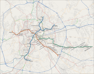
Rome Metro
Rome Metro is the rapid transit system serving the city with three underground lines. The first track opened in 1955. The total length of the network is 60 km (37 mi) with 73 stations. There are three lines A, B - plus a branch called B1 - and C. Lines A and B intersect at Roma Termini station; line C is completely automated but is not yet connected to the rest of the network.
A fourth line, line D, is under development. It will have 22 stations over a distance of 20 km (12 mi).
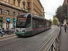
Trams and commuter rail
Rome's overground rail transport comprises the tramway network, suburban and urban lines in and around the city of Rome, plus an "express line" to Fiumicino Airport. Whereas most FS-Regionale lines (Regional State Railways) provide a largely suburban service with more than twenty stations scattered throughout the city, a metro-like service is provided by the Roma-Lido (starting at Ostiense station) and Roma-Nord (starting at Flaminio station) rail lines, but with lower frequencies than Metro lines, as the Rome–Giardinetti light rail line. There is also the Lazio regional railways, a commuter rail system with seven lines which link the suburbs of the Rome Metropolitan Area. One of these lines serves the second airport of the city, Ciampino.
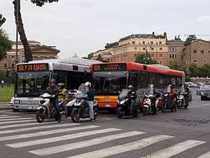
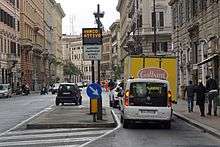
Buses
Rome has a comprehensive bus network, including one trolleybus routes (with additional trolleybus lines under construction). The Metrebus integrated fare system allows holders of tickets and integrated passes to travel on all companies vehicles, within the validity time of the ticket purchased.[3]
Railways

Rome is one of the major hubs of Italian railway network, along with Milan and Bologna. The main railway station serving the city, Roma Termini, is the busiest station in Italy and one of the largest in Europe. The second largest station in the city is Roma Tiburtina, which is being redeveloped for high-speed rail service.[4] Other notable stations include Roma Ostiense, Roma Trastevere, Roma Tuscolana, Roma San Pietro, Roma Nomentana and Roma Casilina.
Roads
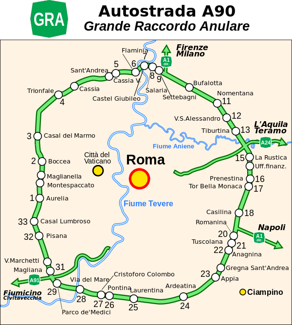
Rome is served by an extensive motorway network. The most important motorway serving the city is the A90, also known as Grande Raccordo Anulare or GRA (Great Ringroad) which run in a circle around the city. The GRA is connected to the Roman branch of the A1 Milan - Naples and other two motorways which arrive further inside the city: the A24 Teramo - Roma and the A91 Roma - Fiumicino Aeroporto.
Traffic congestion in Rome is notorious.[5] This issue is caused mainly by the undersized public transport network and the extremely high cars per capita ratio in the city. It is one of the highest ratios in the country. The Province of Rome is the second province in Italy by automobiles per capita (0,687) and 5th by vehicles per capita (0,87).[6]
A small bicycle sharing system started in 2008.[7]
Motor Traffic Limited Zone (ZTL)
Chronic congestion caused by cars led to the partial banning of motor traffic from the central part of the city during workdays, from 6 am to 6 pm.[8] This area is called Zona a Traffico Limitato (ZTL), motor traffic limited zone.[9]
Heavy traffic due to night-life crowds during weekends led in recent years to the creation of other ZTLs in the Trastevere and S. Lorenzo districts during the night, and to experimentation with a new night ZTL also in the city centre (plans are underway to create a night ZTL in the Testaccio district as well). In spite of all these measures, traffic in Rome remains an unsolved problem.
Airports
Rome is served by three civil airports. The intercontinental Leonardo Da Vinci Airport is Italy's largest airport both for national and international traffic and is one of the busiest in Europe. It is more commonly known as Fiumicino, as it is located within the territory of the nearby comune of Fiumicino, in the south-west of Rome. The older Rome Ciampino Airport is a joint civilian and military airport. These main two airports are owned and managed by Aeroporti di Roma.
The third airport serving the city, the Aeroporto dell'Urbe, is a small, low-traffic airport located about 6 km (3.7 mi) north of the city centre, which handles most helicopter and private flights.
A fourth airport in the eastern part of the city, the Aeroporto di Centocelle (dedicated to Francesco Baracca), is no longer open to civil flights; it hosts the Comando di Squadra Aerea (which coordinates the activities of the Aeronautica Militare) and the Comando Operativo di Vertice Interforze[10] (which coordinates all Italian military activities), although large parts of the airport are being redeveloped as a public park.
.jpg)
See also
References
- ↑ Roma servizi per la Mobilità mission
- ↑ Atac mission
- ↑ "Tickets and Passes". ATAC SpA. Retrieved April 16, 2011.
- ↑ http://eurostar-av.trenitalia.com/it/progetto/stazioni_rinnovate/roma_tiburtina.html - Entry on Roma Tiburtina station on the official website of the Italian high-speed rail service (in Italian)
- ↑ 50 Years in a Cab: A Long, Winding Trip for One Driver, and His City By Elisabetta Povoledo 13 April 2016 New York Time
- ↑ "Rapporto sulla qualità della mobilità nelle province italiane" (PDF). Automobile Club d'Italia (ACI). p. 20. Retrieved 25 October 2011.
- ↑ Rome launches Bicycle Sharing Scheme by James Owen 27 Jun 2008 The Telegraph
- ↑ http://urbanaccessregulations.eu/countries-mainmenu-147/italy-mainmenu-81/lazio-region/rome-ar-2
- ↑ "Rome ZTL Zone Maps & Hours". Auto Europe. Retrieved 14 June 2016.
- ↑ http://www.difesa.it/SMD/COI/La+sede.htm - Entry about the Centocelle Airport in the official website of the Italian Ministero della Difesa
External links
![]() Media related to Transport in Rome at Wikimedia Commons
Media related to Transport in Rome at Wikimedia Commons
- ATAC – official site (Italian)
| .svg.png) | |
| FL lines | ||
| Local railways | ||
| Urban surface systems | ||
| Ticketing systems | ||