Transport in Bristol
Bristol is a city in south west England, situated near the Bristol Channel coast, approximately 115 miles (185 km) west of London. Several factors have influenced the development of its transport network. It is a major centre of employment, retail, culture and higher education, has many historic areas, and has a history of maritime industry. The city has a population of 400,000, with a metropolitan area of 550,000, and lies at the centre of the former County of Avon, which includes many dormitory towns, and has a population of one million. Additionally, it has the seventh highest population density of any English district.
National and international connections

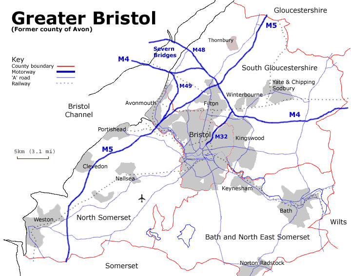
The city is connected by road on an east-west axis from London to Wales by the M4 motorway, and on a north-southwest axis from Birmingham to Exeter by the M5 motorway. Also within the authority area is the M49 motorway, a shortcut between the M5 in the south and M4 Severn Crossing in the west.
.jpg)
There are two principal railway stations in Bristol they are Bristol Parkway and Bristol Temple Meads. There are also scheduled coach links to most major UK cities.
The city is also served by its own airport, Bristol Airport (BRS), at Lulsgate, which has seen substantial improvements to its runway, terminal and other facilities. The airport offers services to major European destinations, but the service to Newark Airport near New York City was withdrawn in November 2010.
Public transport
Public transport within the city is still largely bus-based, with Bristol Bus Station being located in Marlborough Street, near the Broadmead shopping area. The majority of the local bus service is operated by First Bristol. The central part of the city also has water-based routes, operated as the Bristol Ferry Boat, which provide both leisure and commuter services on the harbour. Bristol has over 50 bus and coach services operating in the city, providing links not just around the city but also rail links, park and rides and links to other major UK cities.
Bristol has never been well served by suburban railways, though the Severn Beach Line to Avonmouth and Severn Beach survived the Beeching Axe and is still in operation today – in 2006 funding was secured to improve the frequency of services on this line from late 2007. The Portishead Railway was closed in the Beeching Axe but was relaid between 2000–2002 as far as the Royal Portbury Dock with a Strategic Rail Authority rail-freight grant. Plans to relay a further three miles of track to Portishead, a largely dormitory town with only one connecting road, have been discussed but there is insufficient funding to rebuild stations.[1]
Two companies, Bristol Ferry Boats and Number Seven Boat Trips, operate scheduled passenger ferry boat services in Bristol Harbour in the centre of Bristol. The services run the length of the harbour from Hotwells to Bristol Temple Meads railway station via SS Great Britain and The Centre, serving 15 landing stages. They are used for both commuting and leisure purposes.
The north of the city is served by Bristol Parkway railway station.
Local road network

The A4174 "Avon ring road" serves as a relief road for parts of the northern, eastern, and southern suburbs of the city. During 2006 plans have been considered to extend the existing A4174 ring road to improve transport links in the south.[2]
Bristol city centre was, until the 1990s, surrounded by a ring road. Its course included a dual carriageway road running diagonally through the centre of Queen Square.[3] This has since been partially dismantled, but major routes still converge on the city centre. Radiating from this are several major arterial roads. The M32 motorway, constructed between 1966 and 1975, runs north from the centre to the M4,[4] and is the busiest route. The A4 runs east to Keynsham and Bath, and west via the Portway through the Avon Gorge to the M5 at Avonmouth. The northern suburbs are served by the A4018 and A38 Gloucester Road, the east by the A420, A431 and A432 and the south by the A37 and A38. Several other commuter towns also lie on major routes radiating from the city, including Weston-super-Mare on the A370 and Portishead on the A369.
Cycling

Despite being hilly, Bristol is one of the prominent cycling cities of England. Bristol is home to the national cycle campaigning group Sustrans. It has a number of urban cycle routes, as well as links to National Cycle Network routes to Bath and London, to Gloucester and Wales, and to the south-western peninsula of England. 7.7% of journeys to work are by bicycle.[5] Between 1991 and 2001 Bristol had the third highest increase in bicycle use of any UK council area, at 1.64%.[6] Following the 2001 Local Transport Plan cycling increased even more rapidly, with a 21% increase in journeys.[7]
Bristol was recently awarded £22.8 million to double its cycling population after being awarded "cycling city" status. More information can be found at the region's cycling website Better By Bike
Motorcycles
Bristol is a motorcycle friendly city. The city council recognises that motorcycle use eases congestion as motorcycles take up less space both on the road and when parked. Its motorcycling policy includes the following:[8]
- Motorcycles have been allowed to use most of the bus lanes in the city since 1996.[9] Bristol was one of the first cities in the United Kingdom to permit bus lane use, following a campaign by the local branch of the Motorcycle Action Group (MAG). Motorcycles are also permitted to use the high-occupancy vehicle lane (HOV) on the A370 Long Ashton bypass and the HOV lane on the A4174 ring road.[10]
- Free motorcycle specific parking areas are provided across the city, which are fitted with ground anchors so that motorcycles can be locked. A map is published by the city council showing these and other areas where motorcycles can be parked for free.[11]
- The local Safety Camera Partnership uses money from speeding fines to fund motorcycle safety courses for riders from Bristol, Bath & North East Somerset, North Somerset and South Gloucestershire.
Car Clubs
Bristol is also home to two Car Clubs which operate a variety of vehicles across the city. The cars are parked in a variety of on street bays as well as in private residences and public car parks. The popularity of Car Clubs is a result of the lack of parking within central areas and contributes to the sustainable urban transport plan for the city. Co-wheels car club, a social enterprise, has over 10 vehicles available to hire in Bristol, including electric cars in the city centre.[12] ZipCar (Formerly StreetCar) has a fleet of 16 vehicles based in the city[13] and City Car Club has around 50 cars, both within the city centre and in suburban areas.[14]
Current problems
The rate of traffic increase in the Greater Bristol area has been up to three times the national average, and during peak time 50% of motorway traffic is local.[5] Without intervention the council predicts that between 2006 and 2016 an additional 20,000 people would be commuting in cars. Average peak time speeds in Bristol are 16 mph (26 km/h), the lowest of the eight English "core cities", with 23% of journey times spent stationary, costing the local economy £350 million per year.[7] Cars are used for 45% of journeys under 2 km, and 68% of 2–5 km journeys.[5] The dormitory towns of Weston-super-Mare, Clevedon and Portishead, which have good connections to the M5, but poor public transport systems, contribute to the congestion, and have growing populations.

Bristol's bus service, run by First Bristol, has been a regular target of criticism. The University of the West of England Student's Union described First Bus as "unsatisfactory" and "untenable",[15] while the 2006 Local Transport Plan describes public transport in Bristol as unattractive and expensive.[5] Bristol East MP, Kerry McCarthy, has stated that attempts to get motorists onto public transport will fail when, as in Bristol, providers repeatedly put fares up above the rate of inflation.[16] In 2005 the company was fined £96,250 for delays, and nearly lost a sixth of its vehicle licenses due to poor maintenance.[17] FirstGroup in Bristol have a target 95% punctuality (maximum five minutes late), but in January–February 2008, punctuality was 83.9%, and reliability 97.5%.[18]
In addition to problems with local public transport, the main local rail franchise, First Great Western, has a poor record of punctuality, with only 71% of trains reaching their destinations on time. In January 2007 and January 2008, fare strikes were organised, during which fake tickets were issued to passengers during morning commutes.[19][20]
Future developments
Since 2000 the city council has included a light rail system in its Local Transport Plan, but has so far been unable to fund the project. The city was offered European Union funding for the system, but the Department for Transport did not provide the required additional funding.[21] In November 2016, the West of England Local Enterprise Partnership began a consultation process on their Transport Vision Summary Document, outlining potential light rail/tram routes from the city centre to Bristol Airport, the eastern and north west fringes of the city, and a route along the A4 road to Bath.[22]
As well as improvements to public transport, the 2005 Greater Bristol Strategic Transport Study, commissioned by the regional government office, recommended road building to tackle congestion. These include re-routing and extended the South Bristol Ring Road. The road is currently partially single carriageway and indirect, terminating at the A38 in a built-up area. When the current sections of the road were built it was intended that the road would continue as dual carriageway to a section of the A38 further south, and development prevented on the intended route. The proposals follow this route west from Hengrove Park roundabout to the A38 at Castle Farm (phase 1), and from there to the A370 near Long Ashton Park and Ride (phase 2). There are additional recommendations (phase 3) for a new Whitchurch bypass from Hengrove Park roundabout, along the base of Dundry Hill, around Stockwood and joining the existing A4174 at Hicks Gate roundabout on the A4.[23] Phase one and two of the ring road are the only major road building schemes adopted by the Joint Local Transport Plan, which claimed they would reduce delays across the Greater Bristol area by 6%, and lead to a 9% increase in public transport use.[24] Bristol City Council has since endorsed all three phases, hoping to begin construction of the first two phases in 2010 and 2011, and the third phase potentially some time after 2016.[2]
There are several other major road developments proposed by the Strategic Transport Study.[23] Emersons Green, a rapidly expanding business and industrial suburb with a £300 million "science park" currently in development, could be connected to the M4, with a new junction where the motorway crosses the dismantled Midlands railway (ST689779) and a new road following the route of the railway to the A4174 roundabout (ST675771). When St Philip's Causeway was built by Bristol Development Corporation in the 1980s, connecting the M32 in St Pauls to the A4 at Arno's Vale, it was originally intended to be part of a larger road scheme.[25] A proposed Callington Road Link would extend the road along the route of the dismantled Radstock railway line to the A4174, with a junction on the A4. Bristol Airport has also been attracting increasing levels of transport to roads south of Bristol, and an Airport link has been discussed for several years. Two schemes are suggested in the STS, both entirely new roads. One route connects Junction 20 of the M5 at Clevedon to the west end of the Long Ashton bypass as a new "Nailsea Bypass", coupled with an "Orange Route" link from the Long Ashton bypass, approximately one kilometre from its west end, to the A38 at the B3130 junction. The other route would run from the A38 just south of the airport, north of Wrington and south of Congresbury to the M5 at Weston-super-Mare. The final major project proposal is a second Avonmouth Bridge. This would be a lower level to the M5 bridge, with a swing or lifting mechanism, to the West of the existing bridge, and would relieve the motorway of the local traffic it carries.[26]
Work began in 2015 on the MetroBus bus rapid transit system and will be operational in 2017, providing a new faster public transport service and aims to tackle traffic congestion, improving transport links to South Bristol, reducing journey times and eliminate the need for bus changes.[27] Rail services in Bristol currently suffer from overcrowding and there is a proposal to increase rail capacity under the Greater Bristol Metro scheme.[28]
Transport used for commute
Source: 2001 census[29]
| Mode of transport | Bristol % | National % | |
|---|---|---|---|
| Car driver | 55.20 | 61.78 | |
| On foot | 12.78 | 9.68 | |
| Bus or coach | 11.08 | 4.72 | |
| Car passenger | 6.35 | 6.77 | |
| Bicycle | 4.12 | 2.52 | |
| Motorcycle | 1.67 | 1.06 | |
| Taxi | 0.25 | 0.36 | |
| Other | 0.31 | 0.49 | |
| Work from home | 7.40 | 9.48 |
More recent but less thorough data from a survey of commuters into inner city employers produced the following results.
- [30] Car as a driver 38.6%, Walk 20.8%, Cycle 12.1%, Bus 8.6%, Car – as a passenger 5.8%, Train 5.8%, working from home today 1.5%, Motorbike 1.6%, Park and Ride 1.5%. These numbers, with high walking/cycling, low work from home may be consistent with the survey, as they are a selective count of people who work in the inner city -not in the North Fringe, nor from home unless their employer is one of the set based in the city and included in the survey.
References
- ↑ House of Commons Debate, 2005. "Bristol-Portishead Rail Link." Hansard, Monday, 24 January 2005.
- 1 2 "South Bristol Link" (PDF). West of England Partnership. Retrieved 26 December 2015.
- ↑ "Great city walks: Bristol". The Guardian. 2 February 2015. Retrieved 16 November 2015.
- ↑ "M32 : Dates". The Motorway archive. Retrieved 16 November 2015.
- 1 2 3 4 2011 Census. "."
- ↑ John Parkin, Bolton Institute Comparisons of cycle use for the journey to work from the '81, '91 and 2001 censuses. Traffic Engineering and Control, September 2003, cited in "Lies, damn lies and statistics." Accessed 12 April 2006.
- 1 2 B&NES, Bristol City, North Somerset and South Gloucestershire councils, 2006. "Joint Local Transport Plan." Chapter 1. (PDF)
- ↑ "Motorcycles". Bristol City Council. Retrieved 24 September 2007.
- ↑ "Motorcyclists using Bus Lanes". Bristol City Council. Retrieved 24 September 2007.
- ↑ "Car-share lane". South Gloucestershire Council. Retrieved 24 September 2007.
- ↑ "Where to Park in Bristol". Bristol City Council. Retrieved 26 December 2015.
- ↑ http://www.co-wheels.org.uk/bristol
- ↑ http://www.zipcar.co.uk/bristol
- ↑ http://www.citycarclub.co.uk/locations/bristol-car-hire
- ↑ UWESU, 2006. AGM (PDF).
- ↑ Kerry McCarthy, et al., 17 January 2006. Oral Answers to Questions — Transport, House of Commons / Hansard.
- ↑ BBC News Online, 2005. "Bus firm must reduce city fleet."
- ↑ FirstGroup Performance Statistics.
- ↑ BBC News, Second train fare strike planned
- ↑ BBC News, Fare strikers target rail service
- ↑ James Skinner, 2006. "Memorandum on Government Discrimination against Innovative Low-cost Light Rail in favour of Urban Diesel Buses." Sustraco / H.M. Treasury.
- ↑ "West of England Joint Transport Study - Transport Vision Summary Document" (PDF). Retrieved 16 November 2016.
- 1 2 Atkins, 2005. "Greater Bristol Strategic Transport Study." Chapter 6.
- ↑ B&NES, Bristol City, North Somerset and South Gloucestershire councils, 2006. "Joint Local Transport Plan." Chapter 6. (PDF)
- ↑ Impact of Urban Development Corporations in Leeds, Bristol & Central Manchester, 1998, Department of Communities and Local Government, accessed 25 September 2009
- ↑ "Second crossing planned for Avon". BBC. Retrieved 26 December 2015.
- ↑ "MetroBus Benefits". Travelwest. Retrieved 22 April 2016.
- ↑ "Greater Bristol Metro" (PDF). West of England Partnership. Retrieved 20 September 2009.
- ↑ Office for National Statistics, 2001. Key Statistics 15: Travel to Work.
- ↑ Big Commuter Count 2008 Big Commuter Count 2008
External links
| Wikimedia Commons has media related to Transport in Bristol. |
- Transport in Bristol at DMOZ
- Bristol City Council's website for local transport: TravelBristol.org
- Bristol Taxi Numbers