Transport in Berlin


Berlin has developed a highly complex transportation infrastructure providing very diverse modes of urban mobility.[1] 979 bridges cross 197 kilometers of innercity waterways, 5,334 kilometres (3,314 mi) of roads run through Berlin, of which 73 kilometres (45 mi) are motorways.[2] Long-distance rail lines connect Berlin with all of the major cities of Germany and with many cities in neighboring European countries. Regional rail lines provide access to the surrounding regions of Brandenburg and to the Baltic Sea.
Road transport

In 2006, 1.416 million motor vehicles were registered in the city. With 416 vehicles per 1000 inhabitants (587/1000 in Germany), Berlin as a German state and as a major European city has one of the lowest numbers of cars per capital.[3]
Autobahn
Berlin is linked to the rest of Germany and neighbouring countries by the country's autobahn network, including the:
- A2 to Hannover and the Ruhr area, with links to Frankfurt am Main and western Germany
- A9 to Leipzig, Nuremberg and Munich, with links to Frankfurt am Main and southern Germany
- A11 to Szczecin, with links to north-east Germany and Poland
- A12 to Frankfurt (Oder), with links to Poland
- A13 to Dresden, with links to Poland and the Czech Republic
- A24 to Hamburg, with links to Rostock and north-west Germany
All of these autobahn terminate at the A10 Berliner Ring, a 196-kilometre-long (122 mi) autobahn that encircles the city at some distance from the centre, and largely in the surrounding state of Brandenburg. Central Berlin is connected to the A10 by several shorter autobahns:
- A111 to the northwest (towards the A24 and Tegel Airport)
- A113 to the southeast (towards the A12, A13 and Schönefeld Airport)
- A114 to the north (towards the A11)
- A115 to the southwest (towards the A2 and A9)
The A111, A113 and A115 connect with the A100 Berliner Stadtring, an autobahn that forms a half circle to the west of the inner city, and is one of the busiest motorways in Germany.[4] There are plans to extend this motorway to form a full circle around the inner city.
Cycling

Berlin is known for its highly developed bike lane system. Around 1,500,000 daily rides account for 13% of total traffic in 2008. The Senate of Berlin aims to increase the number to 18-20% of city traffic by the year 2025.[5] Riders have access to 620 kilometres (390 mi) of bike paths including some 150 kilometres (93 mi) of mandatory bicycle paths, 190 kilometres (120 mi) of off-road bicycle routes, 60 kilometres (37 mi) of bike lanes on the roads, 70 kilometres (43 mi) of shared bus lanes which are also open to bicyclists, 100 kilometres (62 mi) of combined pedestrian/bike paths and 50 kilometres (31 mi) of marked bike lanes on sidewalks.[6][7] A system of bike-sharing stations across the city cetre is being implemented by Deutsche Bahn since 2011, starting in Prenzlauer Berg and Mitte
The Berlin-Copenhagen Cycle Route (Radfernweg Berlin-Kopenhagen) is a 630 km (390 mi) long-distance cycling route that connects the German and Danish capital cities. The German portion of the route, between Berlin and Rostock, is approximately 370 km (230 mi); the Danish portion, between Gedser and Copenhagen, is approximately 260 km (160 mi). From Rostock to Gedser, cyclists must take a ferry.
Water transport

Berlin is linked to the Baltic Sea, the North Sea, and the River Rhine by an extensive network of rivers, lakes and canals. An equally extensive network of waterways exists within the city boundaries, providing local access and various short-cuts. The waterways accommodate a mixture of commercial traffic, sightseeing tour boats, ferries and a large fleet of private leisure boats.
Waterways
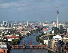
Berlin city centre is located on the River Spree, which runs roughly east to west across the city. The River Dahme joins the Spree at Köpenick, in the city's eastern suburbs. At Spandau the Spree joins the River Havel, which flows roughly north to south along the city's western boundary. To both east and west of the centre of Berlin, all three of these rivers flow through substantial chains of lakes. These include the Tegeler See and Großer Wannsee to the west, and the Müggelsee, Langer See, Seddinsee and Zeuthener See to the east.[8]
The Elbe–Havel Canal links the River Havel downstream of Spandau with both the River Elbe, which flows into the North Sea at Hamburg, and with the Mittelland Canal, which stretches across Germany to a network of canals that provide a link to the River Rhine. Both the Oder–Havel and Oder–Spree canals provide routes from the Berlin area to the River Oder, which flows into the Baltic Sea near Szczecin and provides links to Poland. The Oder-Havel Canal links with the River Havel north of Spandau, whilst the Oder-Spree Canal links with the River Dahme east of Köpenick.[8]
The most important canals within Berlin run roughly east to west between the rivers Spree and Havel. The canal system to the north of the Spree begins with the Berlin-Spandau Ship Canal, which runs from the Spree near the Hauptbahnhof to the River Havel above Spandau. The Westhafen Canal and the Charlottenburg Canal, both near Charlottenburg, provide further connections between the Berlin-Spandau Ship Canal and the River Spree.[8]
The main canal to the south of the Spree is the Teltow Canal, which runs from the Dahme south of Köpenick through the southern part of Berlin to an arm of the Havel just east of Potsdam. A shorter canal, the Landwehr Canal, parallels the Spree through the centre of Berlin. It begins at the Spree between Treptow and Kreuzberg and rejoins the Spree in Charlottenburg. The Neukölln Ship Canal connects the Landwehr Canal with the Teltow Canal; while the Britz Canal connects the Teltow Canal with the Spree at Baumschulenweg.[8]
Whilst not within Berlin, the existence of the city and its partition led to the construction of the Havel Canal in 1951-2. This canal provides an alternative route between Hennigsdorf and Paretz, both then in East Germany, and avoids the stretch of the River Havel that was under the political control of West Berlin.[8]
Ports
_Administration_Building.jpg)
Berlin's largest port is the Westhafen ("west port"), in Moabit (Mitte), with an area of 173,000 m² (42.75 acres). It lies at the intersection of the Berlin-Spandau Ship Canal and the Westhafen Canal. It handles the shipping of grain and pieced and heavy goods. The Südhafen ("south port"), which actually lies along the Havel in Spandau, in far western Berlin, covers an area of about 103,000 m² (25.5 acres) and also handles the shipping of pieced and heavy goods. The Osthafen ("east port"), with an area of 57,500 m² (14.2 acres), lies along the Spree in Friedrichshain. The Hafen Neukölln, with only 19,000 m² (4.7 acres), is located along the Neuköllner Ship Canal in Neukölln. It handles the shipping of building materials.
Sightseeing boats operate on the central section of the River Spree and its adjoining waterways on a frequent basis. Common tours operated include short tours on the River Spree in the city centre, and a three-hour circuit of the city centre via the River Spree and the Landwehr Canal. Other sightseeing boats operate on the various lakes to the east and west of Berlin.[8][9]
Several ferry services operate on and across Berlin's waterways (see ferries below).
Public transport

Berlin's local public transport network is unter the regional transit authority named Verkehrsverbund Berlin-Brandenburg (VBB), a common undertaking of the two federal states (Bundesland) Berlin and Brandenburg, plus the counties (Landkreis) and cities of the Land of Brandenburg. The VBB is the planning authority for regional transport, awards service contracts to private and public companies, and sets the tariffs. For transport lines and networks which do not pass a county's borders, the locality is responsible. This means also that the city-state of Berlin is the sole authority to award service contracts for networks and lines which do not pass beyond the city limits, but has to come to an agreement with the surrounding Land Brandenburg for regional rail and bus transport, i.e. the S-Bahn and regional trains.
The city's transit networks consists of several separate networks, with heavy and light rail transport with five different and incompatible electrification systems. These include the U-Bahn and S-Bahn urban rail systems, regional railway services, a tramway system, a bus network and a number of ferry services. There are a large number of common interchange stations between the different modes.
All these services are, as explained above, under the common public transport tariff run by the Verkehrsverbund Berlin-Brandenburg (VBB). This covers the city of Berlin and approximately 15 kilometres (9.3 mi) beyond the city boundaries. The area is split into three zones. Zone A is the central parts of the city (inside the Ringbahn), and zone B is the outer parts of Berlin City. Zone C covers an area beyond the city boundaries.[10][11]
Ticket fares have a slight price difference between these three zones. For instance, in June 2012, a one-day ticket for zone A+B was priced at €6.30, a zone B+C one-day travel ticket was €6.60, and for all three zones A+B+C, the price was €6.80.[10][11]
Railways
- Berlin Railways from 1846 to 1896 and their successive nationalization
 1846
1846 1851
1851 1867
1867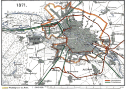 1871
1871 1877
1877 1882
1882 1891
1891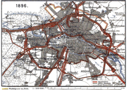 1896
1896
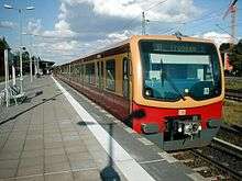
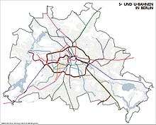
U-Bahn

The U-Bahn is an urban rapid transit rail system, and is entirely within the city borders. Whilst the majority of the system is underground, significant sections operate on elevated tracks or at street level. It is operated by the Berliner Verkehrsbetriebe (BVG), the city owned municipal transport operator, and uses the common public transport tariff managed by the Verkehrsverbund Berlin-Brandenburg (VBB).
The U-Bahn now comprises nine lines with 173 stations and a total length of 147 kilometres (91.3 mi). Trains run every two to five minutes during peak hours, every five minutes for the rest of the day and every ten minutes in the evening and on Sunday. They travel 132 million km (83 million mi), carrying 400 million passengers, over the year.[12][13]
.jpg)
The first line of the U-Bahn opened in 1902, and construction has continued spasmodically since then, with the most recent line opening in 2009. The first four lines to be built were built with a narrower profile and a slightly different electrification method to the later lines. This is most noticeably seen in the narrower trains on the earlier lines, and rolling stock cannot easily be interchanged between the two groups of lines.
During the division of the city, the U-Bahn system was itself partitioned. One line – the U5 – was entirely within East Berlin, and another – the U2 – was operated in two sections, one by each of the two sides. The remaining lines were nominally within West Berlin, although two of them passed under East Berlin without stopping, except at the Friedrichstraße station, which served as a transfer point and border crossing.
Whilst the city remained partitioned, there was major expansion of the U-Bahn in the west, driven both by the availability of funds from commercially successful West Germany and by the desire to provide alternatives to the East German run S-Bahn. Since reunification, expansion has been less fast.
S-Bahn
The S-Bahn has aspects of both rapid transit and commuter rail operation. Historically it developed from commuter services provided by main line railway operators, but now runs on tracks that are separate from, but often parallel to, other trains. Most of the system is operated at ground level, but there are significant sections of elevated tracks and tunnels. It has a somewhat longer average distance between stations than the U-Bahn, and it also serves some of the closer suburbs in Brandenburg. It is operated by a subsidiary of Deutsche Bahn, the national rail operator, and uses the common public transport tariff managed by the Verkehrsverbund Berlin-Brandenburg (VBB).[14]
The S-Bahn now comprises 15 routes with 166 stations and a total length of 331 kilometres (205.7 mi). Over much of the network more than one route provides service over the same tracks, and these routes all feed into one of three core lines: a central, elevated east-west line (the Stadtbahn), a central, mostly underground north-south line (the Nord-Süd-Tunnel), and a circular, mostly elevated line (the Ringbahn).[15]
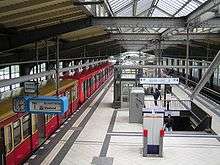
The Stadtbahn carries both S-Bahn trains and regional and long-distance trains, on two separate pairs of tracks. This line passes through most of the city's long-distance and regional train stations, including Berlin Zoologischer Garten, Berlin Hauptbahnhof, Friedrichstraße, Alexanderplatz, and Berlin Ostbahnhof. The Ringbahn forms a circle around the inner city and crosses the Stadtbahn at Westkreuz ("west crossing") and Ostkreuz ("east crossing"). The Nord-Süd-Tunnel intersects the Stadtbahn at Friedrichstraße and the Ringbahn at Südkreuz and Gesundbrunnen.[15][16][17]
During the East German era the S-Bahn was run by the communist state, initially even in West Berlin. As a result, and as a protest against the building of the Berlin Wall, the S-Bahn was boycotted by West Berliners, and much of the system in West Berlin eventually closed through lack of traffic. In 1984 the BVG took over operation of the West Berlin section of the S-Bahn. After reunification, the two halves of the S-Bahn were reunited under the ownership of the Deutsche Bahn.[14]
Regional trains

Berlin is the centre of a system of regional trains operated by Deutsche Bahn, which operate to destinations within the Berlin-Brandenburg suburban area beyond the range of the S-Bahn. There are two kinds of regional trains, the frequently stopping Regionalbahn (RB), and the faster Regional-Express (RE).
Unlike the S-Bahn, the network of regional trains does not have its own segregated tracks, but rather shares tracks with longer distance passenger and freight services. Within Berlin, regional services stop less frequently than S-Bahn services, especially where they run parallel to U-Bahn or S-Bahn lines.
Regional trains often continue outside the Berlin-Brandenburg suburban area, but within that suburban area they use the common public transport tariff managed by the Verkehrsverbund Berlin-Brandenburg (VBB). This covers the city of Berlin and approximately 20 kilometres (12 mi) beyond the city boundaries. These tickets are not valid on DB InterCity trains, Intercity-Express trains and international trains, even within Berlin.
Trams

Berlin has a tram network comprising 22 tram lines serving 377 tram stops and measuring 293.78 kilometres (182.55 mi) in length. All these services are operated by the Berliner Verkehrsbetriebe (BVG) and use the common public transport tariff run by the Verkehrsverbund Berlin-Brandenburg (VBB).[13]
Of the 22 BVG-operated tram routes, nine are designated as part of the MetroNetz, which provide a high frequency service in areas poorly served by the U-Bahn and S-Bahn. These MetroTram tram lines are recognisable by an M prefix to their route number, and are the only tram routes to operate 24 hours a day.[13]

Berlin's first horse tram opened in 1865, running from Brandenburger Tor to Charlottenburg. In 1881, the world's first electric tramway was opened by Werner von Siemens in Groß-Lichterfelde, now part of Berlin. By 1910, the horse trams had been entirely replaced by electric trams.
Prior to the division of Berlin, tram lines existed throughout the city, but all the tram lines in the former West Berlin had been replaced by bus or U-Bahn services by 1967. However East Berlin retained its tram lines, and the current network is still predominantly in that area, although there have been a few extensions back across the old border.
Besides the BVG tram routes, two further tram lines (numbered 87 and 88) cross the Berlin city boundary in order to connect suburban S-Bahn stations within the city to the Brandenburg towns of Woltersdorf, Schöneiche and Rüdersdorf. A similar line operates within the nearby town of Strausberg, whilst the adjacent city of Potsdam has its own sizable tram network. Whilst none of these lines is operated by the BVG, they all use the VBB common tariff.
Buses
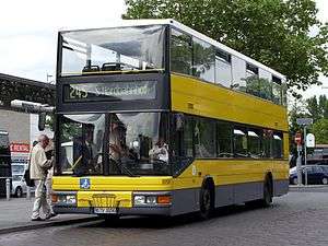
Berlin has a network of 149 daytime bus routes serving 2634 bus stops and with a total route length of 1,675 kilometres (1,041 mi). All these services are operated by the Berliner Verkehrsbetriebe (BVG) and use the common public transport tariff run by the Verkehrsverbund Berlin-Brandenburg (VBB).[13]
Of the BVG-operated bus routes, 17 are designated as part of the MetroNetz, which provides a high frequency service in areas poorly served by the U-Bahn and S-Bahn. Like the MetroTram tram routes, these MetroBus routes can be recognised by an M prefix to their route number. A further 13 BVG-operated bus routes are express routes with an X prefix to their route number.[13]
At nighttime, Berlin is served by a night bus network of 63 bus routes serving 1508 stops and a total route length of 795 kilometres (494 mi). One night bus runs parallel to each U-Bahn line during the weektime closing hours. Most of the MetroNetz bus and tram routes operate 24 hours a day, and form part of both the day and night networks. Again services are operated by BVG and use the VBB tariff.[13]
BVG bus service is provided by a fleet of 1349 buses, of which no fewer than 407 are double-decker buses. Whilst such buses are common in both Ireland and the United Kingdom, their use elsewhere in Europe is extremely uncommon.[13]
Ferries
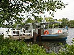
Berlin has an extensive network of waterways within its city boundaries, including the Havel, Spree and Dahme rivers, and many linked lakes and canals. These are crossed by six passenger ferry routes that are operated by the Berliner Verkehrsbetriebe (BVG) and use the common public transport tariff managed by the Verkehrsverbund Berlin-Brandenburg (VBB).[18]
There are also a number of other ferry routes that are not managed by BVG, and do not form part of the VBB common tariff. These include passenger and car ferries serving islands within Berlin's lakes, as well as a car ferry across the River Havel. The adjacent city of Potsdam operates a ferry that is within the VBB common tariff.
Modal split
The modal split between the major modes is a follows:[19]
| System | Stations/ Lines/ Net length | Passengers per year |
|---|---|---|
| U-Bahn | 170 / 9 / 145 km | 457 million |
| S-Bahn | 166 / 15 / 331 km | 376 million |
| Tram | 398 / 22 / 192 km | 171 million |
| Bus | 2627 / 147 / 1,626 km | 407 million |
| Ferry | 14 / 6 / - | - |
Airports

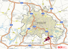
Berlin is served by two commercial airports. Tegel Airport (TXL) is the largest and located within Berlin, while smaller Schönefeld Airport (SXF) is situated just outside Berlin, to the south-east. Combined, they handled 22.3 million passengers in 2010. In 2011, 88 airlines served 164 destinations in 54 countries from Berlin airports, with 28 non-European connections.[20] Tegel Airport is scheduled to close in 2013 and Schönefeld Airport will be expanded and renamed Berlin Brandenburg Airport, handling all commercial flights to and from Berlin.
A third, Tempelhof Airport, formerly handled short distance and commuter flights. It was closed at the end of October 2008. Closure of Tegel and Tempelhof airports is a legal requirement for the opening of the new Berlin Brandenburg Airport south of the Schönefeld Airport site, in order to alleviate noise pollution throughout the city.
History
The first airport in Berlin was Johannisthal Air Field which opened on 26 September 1909. Followed shortly after by Staaken Airport around 1915, known for its two zeppelin halls and Deutsche Luft Hansa base. Then came Tempelhof Airport in 1923 and Gatow Air Field in 1934. Tegel Airport was built during the Berlin Blockade in 1948.
Tempelhof was the first airport in the world with regular passenger flights, opening in 1923 with flights to Königsberg (now Kaliningrad). Deutsche Luft Hansa started its operations from the airport in 1926, while zeppelins also frequented the airport. The airport expanded rapidly, becoming one of the largest airports in the world in the 1930s, fittingly provided with enormous halls, which are still visible today, unfinished though they may be. Tempelhof also had another first: it was the first airport to feature its own underground station.[21]

Following World War II, Tempelhof was used as a U.S. Air Force base, while the Soviet air force relocated to Schönefeld, outside Berlin, during 1946. The Soviets had reached Tempelhof before the Western Allies. Gatow Air Field, which was taken over by the RAF in July 1945, was partially outside Berlin. At the Potsdam Conference it was then decided to exchange the western half of Staaken, including Staaken Airport, for the needed territory in Gatow.[22] Staaken Airport was then used by the Soviet air force for some time to come.
In April 1948, as a result of growing tension between the Soviet and the Western Allied occupying powers, West Berlin was closed off from the surrounding Soviet sector. Supplies were flown in for over a year; enormous numbers of transport planes flew in and out of Berlin every day of this period. The capacity of the airports then in the three Western sectors was not large enough; to relieve pressure on Gatow and Tempelhof, Tegel Airport was built in the French sector. It was constructed by a labour force mainly consisting of Berlin women , under the supervision of French engineers, within just 90 days . It featured a 2400 m runway - the longest in Europe at the time. Because of special Allied bylaws, Lufthansa was not allowed to use Tegel until after German reunification.
Tempelhof was returned to civil administration in 1951, Schönefeld in 1954 and Tegel in 1960. Gatow Airport remained a military airfield, used by the RAF until 1994 and closed in 1995. Tegel, the newest airport, became the main civilian airport for West Berlin, while Schönefeld served the population of East Berlin. Since the smaller airport at Tempelhof is surrounded by urban development, it could not expand.
Berlin Brandenburg Airport

Following German reunification in 1990, the inefficiency of operating three separate airports became increasingly problematic. Berlin's airport authority (the Berliner Flughafen GmbH, a subsidiary of the Flughafen Berlin-Schönefeld GmbH) will transfer all of Berlin's air traffic to a greatly expanded airport at Schönefeld, to be renamed Berlin Brandenburg Airport.[23] The existing airport in Schönefeld will be greatly expanded to the south from its current state to allow this. In fact, the new airport will only have the current southern runway (the new designated northern runway) in common with the existing airport.
Berlin Brandenburg Airport is predicted to be Germany's third busiest airport when it opens, as Berlin's airports served over 22.3 million passengers in 2010.[24] Frankfurt Airport, which served 54 million passengers in 2007, is the country's busiest airport,[25] followed by Munich Airport, which served 34 million passengers in 2007.[25] Due to technical difficulties, the opening has been delayed a couple of times.[26]
See also
References
- ↑ "Broke but dynamic, Berlin seeks new identity". IHT. Retrieved 2008-08-19.
- ↑ "Berlin fact sheet" (PDF). berlin.de. Retrieved 2008-08-19.
- ↑ "Kraftfahrzeuge und Schienenbestand". Destatis. Retrieved 2008-08-19.
- ↑ "Spitzenbelastungen auf bundesdeutschen Autobahnen in Berlin, Köln und Frankfurt". The Federal Highway Research Institute. 2007-03-13. Retrieved 2010-05-25.
- ↑ [Schnellwege, breitere Spuren und ein Parkhaus, Berliner Zeitung, 25 August 2011, http://www.berlinonline.de/berliner-zeitung/archiv/.bin/dump.fcgi/2011/0825/berlin/0020/index.html]
- ↑ "Bike City Berlin". Treehugger. Retrieved 2008-08-19.
- ↑ "Bicycle Routes and Facilities Bicycle Paths" (in German). Senate Department of Urban Development. Retrieved 2008-09-19.
- 1 2 3 4 5 6 Sheffield, Barry (1995). Inland Waterways of Germany. St Ives: Imray Laurie Norie & Wilson. ISBN 0-85288-283-1.
- ↑ Gawthrop, John; Williams, Christian (2008). The Rough Guide to Berlin. London - New York City - Delhi: Rough Guides. pp. 28–29. ISBN 978-1-85828-382-1.
- 1 2 "Tickets / Ticket fares". Verkehrsverbund Berlin-Brandenburg. Retrieved 2012-06-30.
- 1 2 "Tickets & Tarife" [Tickets & Fares] (in German). Berliner Verkehrsbetriebe. Retrieved 2012-06-30.
- ↑ "The Berlin metro (U-Bahn)". Means of Transport & Routes. BVG. Archived from the original on 2007-08-20. Retrieved 2007-09-06.
- 1 2 3 4 5 6 7 "BVG in Zahlen" [BVG in figures] (in German). Berliner Verkehrsbetriebe. 2009-12-31. Retrieved 2010-06-16.
- 1 2 Hardy, Brian (2000). The Berlin S-Bahn Handbook. Capital Transport Publishing. ISBN 1-85414-185-6.
- 1 2 "S-Bahn + U-Bahn Routemap" (PDF). S-Bahn Berlin GmbH. Archived from the original (PDF) on December 29, 2009. Retrieved 2010-06-14.
- ↑ "Map S-Bahn Stadtbahn". S-Bahn Berlin. Archived from the original on March 14, 2008. Retrieved 2008-08-18.
- ↑ "BVG Route planner". Berlin Transport Authority. Retrieved 2008-08-18.
- ↑ "Linien, Netze & Karten - Verkehrsmittel & Linien - Fähre" (in German). BVG. Retrieved 2010-06-14.
- ↑ "Berlin statistical figures" (in German). Statistisches Landesamt Berlin. Retrieved 2008-08-19.
- ↑ "Airport BBI: Einzigartige, historische Chance für Berlin und Brandenburg". airportzentrale.de. Retrieved 10 March 2011.
- ↑ Historic Berlin Airport To Close in 2008 || Jaunted
- ↑ "Großbritannien" (in German). Alliierte in Berlin e.V. Retrieved 2009-07-08.
- ↑ "Airport Berlin Brandenburg International". Airports Berlin. Retrieved 2008-08-18.
- ↑ http://www.berlin-airport.de/EN/Presse/Pressemitteilungen/2009/2009_01_12_Wachstum.html, with more detailed statistics for 2004 available at http://www.berlin-airport.de/DE/Presse/Pressemitteilungen/2004/vb0104.html.
- 1 2 http://www.rankaholics.de/w/die+groessten+flughaefen+deutschlands_1514
- ↑ "New Berlin Airport to Finally Open Next October". Spiegel Online International. 4 September 2012.
External links
![]() Media related to Transport in Berlin at Wikimedia Commons
Media related to Transport in Berlin at Wikimedia Commons
| Administration |
| |
|---|---|---|
| Society | ||
| Other topics | ||
| ||